|
 Altered Landscapes:
It is likely that the landscape was viewed very
differently through prehistoric eyes. The interconnectivity between
ourselves, the constructions and the landscape suggests that the
Earth was perceived as a physically living
canvas which megalithic structures and sacred places were sewn into.
Featured Items:
Article: Pieces
of Landscapes. By Dr. J. Lewis. (Quick-link)
Article: Sacred Places: The Living landscape. By. A.
Whitaker (Quick-link)
The very existence of these ritual landscapes and
the monuments within them suggests the societies building them were
prepared to invest large amounts of time and energy on 'work' that
gave no direct return in terms of food and shelter. Alternatively, it
may suggest a culture which could only envisage such security if such
propitiation was carried out... This would suggest a society that
could produce sufficient surplus to free up such time and effort.
(1)
|
Levelled Hill-tops, Beacon Hills: |
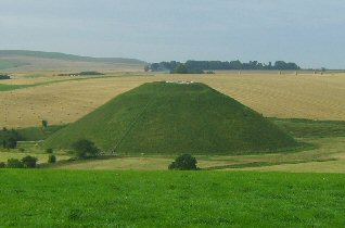
There are a large number of examples of hill-tops in Britain which share
an association with either St. Michael or St. George, both of whom are reputed to have appeared and slain dragons.
Many of these hills or 'Beacon hills' were artificially levelled or constructed as in
the case of Silbury Hill (Right). They
are also associated through traditions and solar rituals involving beacon
fires being lit on their tops, such as on May 8th, St. Michael's day. (Beltane). Many of them still retain the title
of 'Beacon' Hill, and there is a clear association with Ba'al, the
Phoenician sun god..
The tradition of replicating the path of the sun with
beacon fires across the landscape is also seen in the middle east in
the form of Mithraism. The aligned fires create a connection between the
sun, the people and the land, and can be viewed as a means of communicating
with the sun.
Dragon hill - Part of the Uffington ley. (O/S 3070 8686). An excellent example of a natural hill with
an artificially flattened top combined with a clear tradition with
dragon-slaying.
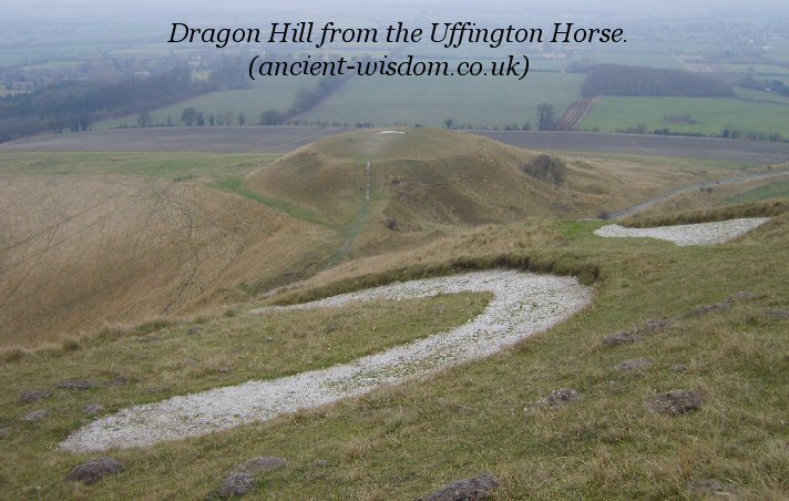
Dragon hill from the Uffington horse.
The overlooking Uffington 'Horse' (of which a small
section can be seen in the foreground of the picture above), is the oldest of
England's 'White-horses'. It is considered by some to have originally
been a dragon, an idea supported by legend as 'Dragon' Hill is said to have
been the site where St. George
slew the dragon, whose blood fell on to the top, preventing grass from ever
growing there.
(More about Dragon Hill)
The selection of prominent natural landscape features
and subsequent construction of megalithic structures reinforced the
connections between the
cosmos, the landscape and the builders.
|
Ley-Lines.
Probably the best known Ley-line is the St. Michael's Ley,
which runs across England and crosses several places associated with dragon slaying.
The same myth exists in France at Mont. Dol, which is
also a part of a solar
alignment including Mont. St. Michel.
(More about St.
Michael)
While it is true that most Ley-lines are
essentially invisible connections, they are nonetheless present on
the landscape to those with the right eyes, and played an important
part of it too. There are various theories concerning the origin and
purpose of Ley-lines, and it is reasonably likely that they served
different functions to different people at different times.
The presence of Ley-lines at some of the
most prominent megalithic sites in England offers a possible clue to the
specific placement of certain megaliths. It can be seen that the
deliberate orientation and alignment of sacred sites was a means of
connecting the cosmos with the landscape, at the same time as
uniting the very landscape itself. There are certain sites (such as
the Orkney complex in Scotland or
the Boyne Valley complex in
Ireland) where it can be seen that the megaliths themselves
become a part of the landscape displaying an attempt to
create a symbiotic relationship between the
cosmos and the living earth.
(More about
Ley-lines)
|
The moment the natural landscape becomes altered by people, those
alterations, in turn became a presence. The constant focus of attention on such
sites imbues them with a sense of tradition, giving them an identity,
which in itself gives a structure a sense of special purpose. The opposite
can be said today where in a modern city, it is the natural presence of
birds and trees that stand out against the artificial backdrop of
humanity.
The idea that the landscape
was a 'canvas' is supported by the ideas and concepts were often
illustrated upon it. The
chalk hills of southern England for example, were used for the design of
several 'White Horses', which are suggested to have originally served as
tribal boundary markers for the Wessex people.
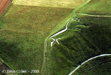 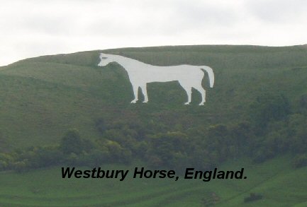
Uffington Horse,
Dragon Hill (left). Westbury Horse
(Right).
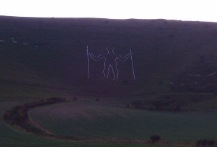
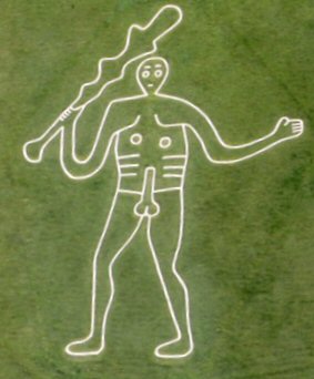
England has several
other chalk drawings on the southern downs, not least the long man of
Wilmington (left), and the Cerne Abbas
Giant (right).
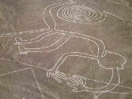
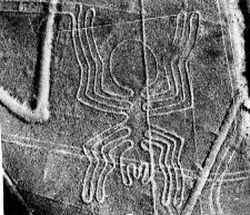
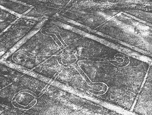
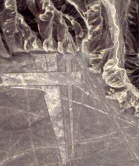
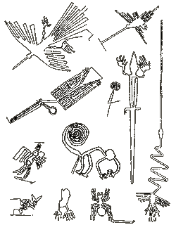 The Nazca Drawings, Peru. The Nazca Drawings, Peru.
These are probably the most famous landscape
designs in the world. They were made by using small stones on the
contrasting colour of the Peruvian desert sands. They are currently
believed to have been made by the 'Nazca culture' between 200
and 700 AD.
The desert stretches over 500 km�, and contains
several hundred of zoomorphic characters, symbols, and large geometric
lines.
There are various theories over their origin and
purpose, but the most likely contenders are astronomy, religion and
crop fertility or perhaps a mixture of them all.
It has been pointed out that the amount of effort
required for each of the larger figures points to civil works, which
again suggests a purpose, but whatever the exact nature of the impetus
for these designs was, they are also created artistically and
precisely and one feels they were made with care and pride.
Some Images from the Nazca Plains.
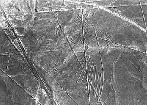
Satellite photos of the Nazca plains.
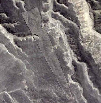
These satellite photos demonstrate that the scale of
some of the shapes dwarfs the zoomorphic shapes themselves. Whole
mountains were levelled in this procedure and it is noticeable in the
photo (right), that these large-scale geometric shapes were
continued accurately over wide chasms.
(Click here for more about
Nazca)
Negative space
Architecture.
Certain megalithic sites display the utilisation of 'negative-space' architecture,
in which the space
itself was used in the architecture of prehistoric structures. We can
see in the Hypogeum on Malta for example,
how the underground cavities were carved so as to reproduce the temples
above ground, including specific features such as
trilithon's, stairwells and rock-cut doorways. In the case of the
'Treasury of Atreus'
from Mycenae, Greece, the use of negative-space resulted in the creation
of an invisible 'Omphalos' or Earth navel
within the space of the structure, imitating the previous traditional
function of the site, which already had a significance
before the 'Treasury of Atreus' was built.
|
The physical moulding of the landscape was a
feature common in prehistoric times with thousands of labour-hours
having been calculated at numerous megalithic sites around the
prehistoric world. Each of these prehistoric earthworks represent a
communication of ideas expressed upon the canvas of the Earth itself.
 Cursus (Cursii). Cursus (Cursii).
Cursus' are
one of the
earliest forms of major earthworks identified in the British Isles.
The Cursus
is a prehistoric landscape feature which appears to have been particular to
Britain and while most are found in England, there are also a few suspected
in Ireland. The scale of these monuments suggests an organised or even civil level
of construction, requiring
hundreds, if not thousands of man-hours for each site. At
Stonehenge, there are two cursus, the larger of which has recently been
dated by Manchester University at 3,500 BC which makes it older than the
first construction phase of Stonehenge itself.
(More about Cursus)
Henges.
 These
earth-works are particular to the British Isles where they are found in
large numbers. Essentially, they involve the construction of a circular bank
of soil/stones, commonly surrounded by a ditch. To an observer
standing inside a true henge, the bank often creates an artificial horizon
(although this is not always so), which has led some to consider the Henge
as an evolution of the Cursus. These
earth-works are particular to the British Isles where they are found in
large numbers. Essentially, they involve the construction of a circular bank
of soil/stones, commonly surrounded by a ditch. To an observer
standing inside a true henge, the bank often creates an artificial horizon
(although this is not always so), which has led some to consider the Henge
as an evolution of the Cursus.
The three
Thornborough henges are believed to
have an astronomical association with the constellation Orion but their size
and design suggests that they served a ritual purpose.
At
Stonehenge, another site associated with
astronomy, the Henge itself was constructed long before the Stone circle, a
feature which is repeated in Britain, leading many to see the Henge as a
precursor
to the stone-circle itself. As if to confound any clear definition of the
purpose of a Henge, the largest in Britain is at
Avebury, which originally had a ditch 15m
deep and an
external
bank over 15m high, yet has no clear or specific astronomy associated to it
whatsoever, although it is a part of the Silbury/Averbury complex, and was
clearly an important part of the ceremonial landscape, having been connected by
the Beckhampton and West-Kennet Avenues to other important sites in the
area.
It is
noticeable that Henges create a similar design as the
cup-and-ring marks
found engraved on the megaliths themselves. Nowhere is this more clear than
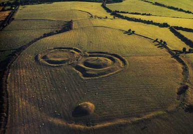
at Tara Hill in Ireland (above), where a
stone inside the mound of the hostages has a set of markings on it which
shows a close resemblance to the layout of the earth-works at Tara.
It can be seen how the same
artistic circular components have been translated into both rock-art and
landscape/temple design.
(More about
Henges)
Passage-mounds and Stone Circles:
The primal 'Mound of Creation'.
There were
several types of prehistoric 'mound' to be seen on the prehistoric landscape.
Many of them are simple 'cairn's' or 'barrow-mounds' and are solely
associated with funerary rituals. However, there are also several other larger
mounds which appear to have served other functions, including the observation
of astronomical events.
The
numerous 'Beacon' Hill's in Britain have been mentioned above, and tradition and
observation shows that they served the same function as passage-mounds but to a larger
audience through the lighting of beacon fires in lines on hill tops across
the open landscape. This too can be seen as a multi-functional act, both
demonstrating a physical connection with the cycles of the cosmos through
aligned landscape features, at the same time as connecting observers.
The
Boyne-valley passage mounds were each
orientated so that the sunlight reached along the passages and into the
central chambers at very specific moments of the solar and lunar cycles. In addition, The same is true of
Maes-Howe on the Orkneys,
Gavr'inis in France,
Bryn-Celli-Ddu in Wales and
Zambujeiro in Portugal. All of these
passage mounds were constructed according to a set of basic astronomical
requirements, which at the same time as enabling the builders to measure the
solar and lunar cycles accurately, physically connected them to the
beating heart of their
universe.
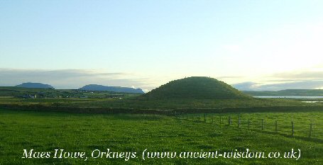
It is proposed that
these mounds were a symbolic representation of the primal 'Mound of
Creation', rising from a watery mythological past. The Maes Howe
mound above is connected to the ceremonial landscape of the Orkneys
through the close proximity of the Stennes circle, and within sight
of that, the larger Brodgar circle, a combination which appears to
have a common thread at several other western European megalithic
complexes: (Avebury/Silbury Hill, Gavr'inis-Er-Lannic, Zambujeiro-Almendres,
Ggantija/Xaghra). Regional variation on this theme has resulted in
several combinations: In Ireland, Tara Hill shows the same features
combined in the same ceremonial setting, only with the mound in the
centre of the circle, Newgrange mound was built over an existing
Stone circle, and Avebury has two circles built within it. This
association of a prominent mound and associated circle/s can be seen
to be one of the basic features of several of the (contemporary
Neolithic) western-European ceremonial arenas. There are several
other more specific similarities which suggest a contact along the
Atlantic coastline of Europe between these civil-scale ritual
complexes.
(Similarities between Neolithic
Western-European Complexes)
(The
Mound Builders of North America)
|
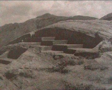
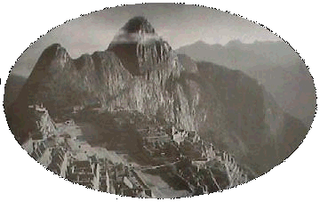
The Throne of the Inca, Cuzco,
Peru.
There are numerous examples of rock-carved mountains
in south America, many of which demonstrate the delicate balance between
carving the natural features of the living rock and exaggerating the
remaining ones.
(The
Pre-Columbian Americas)
|
Simulacrum:
Faces
in the stones.
While it is now known that the tendency to see
anthropomorphic images in inanimate objects is a natural phenomena
associated with imprinting, our prehistoric ancestors viewed the
Earth as a living being, and as such places which demonstrated such
similarities were considered as special or 'sacred'.
(Landscape
Zodiacs/Mandalas)
(More about Simulacrum)
(The
Living Earth)
|