|
 Prehistoric France:
Quick
links:
Of the 6,192 standing
stones, or menhirs...which a count of 1880 reckoned to exist in France,
4,747 were located in Brittany, 3,450 of these being in Morbihan.
(3) 'There are over 5,000 Menhirs in
Brittany alone'. (1)
According to French
statistics of 1864, there are 140,000 'barrows' or 'tumuli' in the
Departments of the Cote-d'Or, Vosges, Haut-Rhin, Bas-Rhin, Doubs, Jura, and
Ain. (2)
According to the
1864 survey, the number of 'Dolmens' in France was then
more than 2,225. (2) Today, the
estimate stands at approximately 4,500.
|
News : The
"lady of Villers-Carbonnel"
(Dec 10, 2011) The Independent:
Rare Earth Mother Figurine found on the Banks of The River Somme.
|
Featured French Locations: |
|
La
Marche Cave Art.
 Of
the 350 known sites of European cave art from the Ice Age, almost
half are located in France. (8) Of
the 350 known sites of European cave art from the Ice Age, almost
half are located in France. (8)
Of all the examples of
French Cave art, La Marche is surely the most puzzling. The art is
confidently dated at 15,000 BP, and was found etched and painted on
hundreds of carefully placed schist slabs covering the cave floor.
The images include several animals but more interesting are the
numerous etchings of faces and heads and several depictions of
people wearing boots, hats and clothing.
Although at first
considered too controversial to contemplate such quality art at a
time when Europe was in the throes of an Ice-age, this art is now
being taken seriously and sheds new light on our existence at
(More about La Marche) |
|
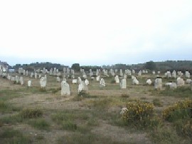 The
Carnac complex.
Possibly the best known megalithic French site, the
road-sign as you enter Carnac has the words 'Cairn-ac'
beneath it, which clearly associates it with 'Cairn' building. However,
John Michel tells us
confidently that the site was named Carnac after the Egyptian
Karnak by the Count Maudet de Penhouet.
(1)
Carnac has the largest concentration of standing stones in
the world, and the area is literally covered in megalithic ruins of every
type dating back to 6,850 BC
(5)
(More about the Carnac complex)
|
|

Le Mont St. Michel.
This fascinating island sanctuary has attracted pilgrims since the middle
ages. Although the dedication to St. Michael can
be traced back to the middle ages, the alignments to other 'St. Michael'
locations (including prehistoric ones), is suggestive of a
deliberate system of placement, which may have operated between certain
ancient sites.
(More about Le Mont St. Michel)
|
|
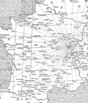
Xavier Guichard
and the 'Alaisian' Mysteries:
-
France was home to a detective called Xavier Guichard, who in the early 20th
century, while investigating the ancient roots of place names, discovered an
prehistoric network of alignments extending throughout France (and
other areas of Europe), which were connected by locations with the root-name
'Alaise', and through longitude and latitude. He concluded that he
had touched upon the Eluesian
mysteries of ancient Greece. His work was entirely independent of Alfred
Watkins work on 'Ley- lines'.
(More about Xavier Guichard)
(Read
Eleusis Alesia: Facsimile of an Original Copy)
|
|
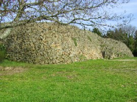
The
Gavr'inis Passage Mound:
Constructed at around 3,300 BC, the passage mound on the
island of Gavr'inis contains one of the most spectacular examples of
engravings in all the prehistoric world. There are several indications that
the builders of Gavr'inis may have been the same people that constructed the
great structures in Ireland at about the same time.
Directly in front of
Gavr'inis are now partially submerged twin stone circles on the small island
of
Er-Lannic.
(More about Gavr'inis)
|
|
Le Grand Menhir Bris�:
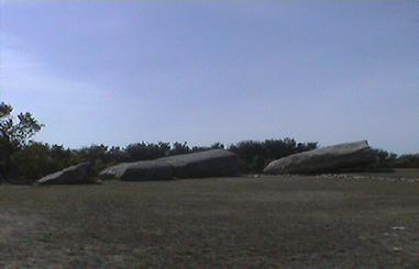 This fantastic stone is 20m from end to end. It was transported from
at around 50 miles distant
(3), and is regularly estimated at over 300 tonnes. This fantastic stone is 20m from end to end. It was transported from
at around 50 miles distant
(3), and is regularly estimated at over 300 tonnes.
This was once the largest standing
stone in all Europe, its presence is a record of capability and excellence
in the Neolithic period, which is a far cry from the traditional view of
primitive Neolithic hunter-gatherers.
The original construction would have included another 18 stones,
which have all gone...or have they?
(More about the Great Menhirs of
Lochmariaquer)
|
|
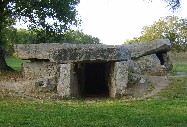
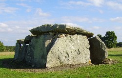
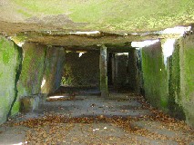
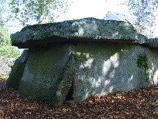
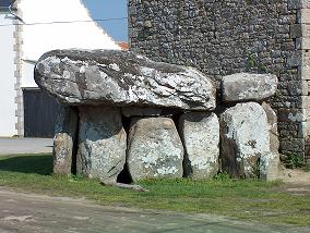
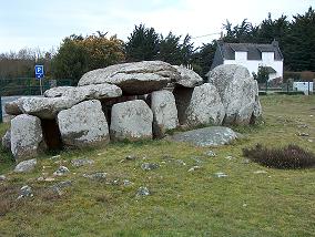
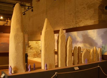
The Great Loire Dolmens:
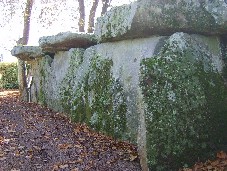 This group of
'Dolmens'
between Saumur and Blois on the river Loire are some of the most impressive
in Europe. They are puzzling to archaeologists as none of them appear to
have ever been covered with earth, and there have been no human remains
found in them, which precludes them from being intended for passage graves
or funerary structures. This group of
'Dolmens'
between Saumur and Blois on the river Loire are some of the most impressive
in Europe. They are puzzling to archaeologists as none of them appear to
have ever been covered with earth, and there have been no human remains
found in them, which precludes them from being intended for passage graves
or funerary structures.
In France an
inter-gradation can be observed between the rudest and most ancient
dolmens and later varieties where the support stones are squared off
into four vertical faces or tapered into cylindrical columns.
(1)
(More about the
Great Loire Dolmens)
|
Carnac, France. (The
progression
from Dolmen to Passage 'Grave/Tomb')
| The
Mystery of the Lochmariaquer Menhirs: |
Le 'Grande Menhir Brise'
(The Large Broken Stone) at Lochmariaquer was once the largest standing stone in all Europe.
Today it lies broken in four parts.
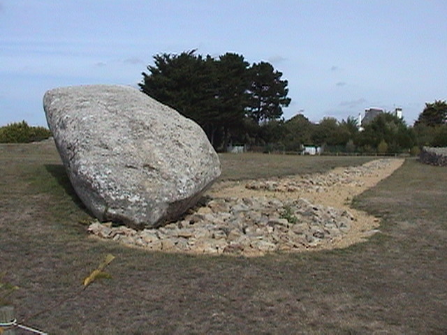
Archaeology has determined that originally, there
were another 18 pits in a row running from the stone, and it is believed that
each once contained a menhir (of decreasing size), which were placed there
at around 4,500 BC.
The length of the remaining stone is 20m from end to
end. If approximately 20% of this stone was originally underground (as
suggested by a local tour-guide), we can assume that it actually stood at
around 16m above ground level.
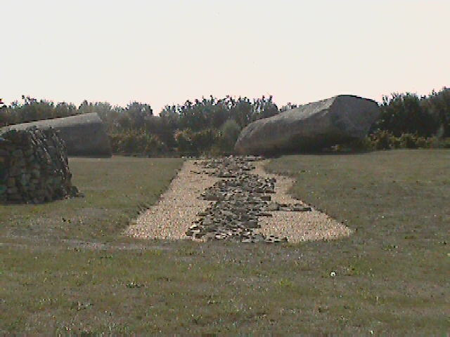
An impression of the design of the original 4,000 BC structure.
At a later date of approximately 3,300 - 3,100 BC, most of these huge menhirs
were re-used and distributed to other locations in the region. The largest stone
(at least) was left upright at this time, as evidenced by the remains of its
fallen parts, which presumably fell at a later date than when the other
stones were taken and re-used.
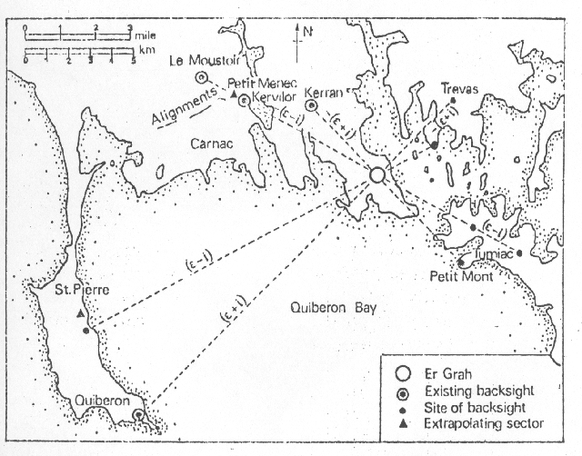
Prof. A. Thom determined that the menhir was
positioned so as to be a giant lunar back-sight for several other nearby
locations.
(More about Le Grand Menhir
Bris� and the Missing Menhirs)
|
Les Megalithic Facts:
In
Charente, France, there is a stone reputed to weigh nearly 40
stones. The nearest source of similar stone is over 18 miles away.
(7) |
| The
Tallest Menhirs in France: |
The Tallest Menhirs in
France .
|
Menhir (Location) |
Height (m) |
Height (ft) |
|
Lochmariaquer (Morbihan) -
(Fallen). |
20.50 |
67.30 |
|
Pl�sidy
(C�tes
du Nord) |
11.12 |
36.50 |
|
Plouarzel
(Finist�re)
at Kerloas |
11.05 |
36.25 |
|
Louargat
(C�tes
du Nord) |
10.30 |
33.80 |
|
K�rien
(C�tes
du Nord) |
9.63 |
31.60 |
|
Dol (Ille-et-Vilaine)
at Champ-Dolent. |
9.30 |
30.50 |
|
Grande
Menhir de Counozouls. |
8.90 |
29.75 |
|
Plouarzel (Finist�re)
near the village |
8.77 |
28.80 |
|
Kergadiou (Brittany) -
(Two menhirs, one fallen) |
8.75 |
28.50 |
|
P�dernec
(C�tes
du Nord) |
8.50 |
27.90 |
|
Menhir
du Men Marz. (Two menhirs, one fallen) |
8.50 |
27.90 |
|
Glomel
(C�tes
du Nord) |
8.50 |
27.90 |
(More about
French Menhirs)
This group of dolmens are
congregated between Samur to Blois, on the river Loire are some of the most
impressive in France. They are puzzling to archaeologists as none of them
appear to have ever been covered with earth, and there have been no human
remains found in them, which precludes them from having been intended for
passage mounds or funerary structures. (1)
They have several construction features which are
peculiar to the area, such as the the portalled entrances, which lead
directly into the large internal chambers. They are invariably orientated
east-west, with the opening facing east, suggesting a preference for
equinoxial orientation.
Other dolmens can also be found north of the Loire at Soucelles, La Roche Thibault,
Bauge, Nr Mettray (La Grotte des Fees). South of the river in the
Samur region there are more west of Gennes and in a farmyard near St. Hilaire (Dolmen de la Pierre Boire),
and the massive Le Gros-Chillou at Briancon, Cravant, which is 50
ft (15.2 metres) long and 10 ft (3.1 metres) high.
(More about the Loire
Dolmens)
(Dolmens Homepage)
|
Palaeolithic France. |
|
Chauvet
Pont D'Arc. |
The Cave
of Forgotten Dreams. Oldest Cave-art on record. |
| Lascaux. |
The
'Sistine Chapel' of Palaeolithic Cave-art. |
|
La
Marche. |
The
Largest Collection of Human Representation in Cave-art.
|
|
|