|
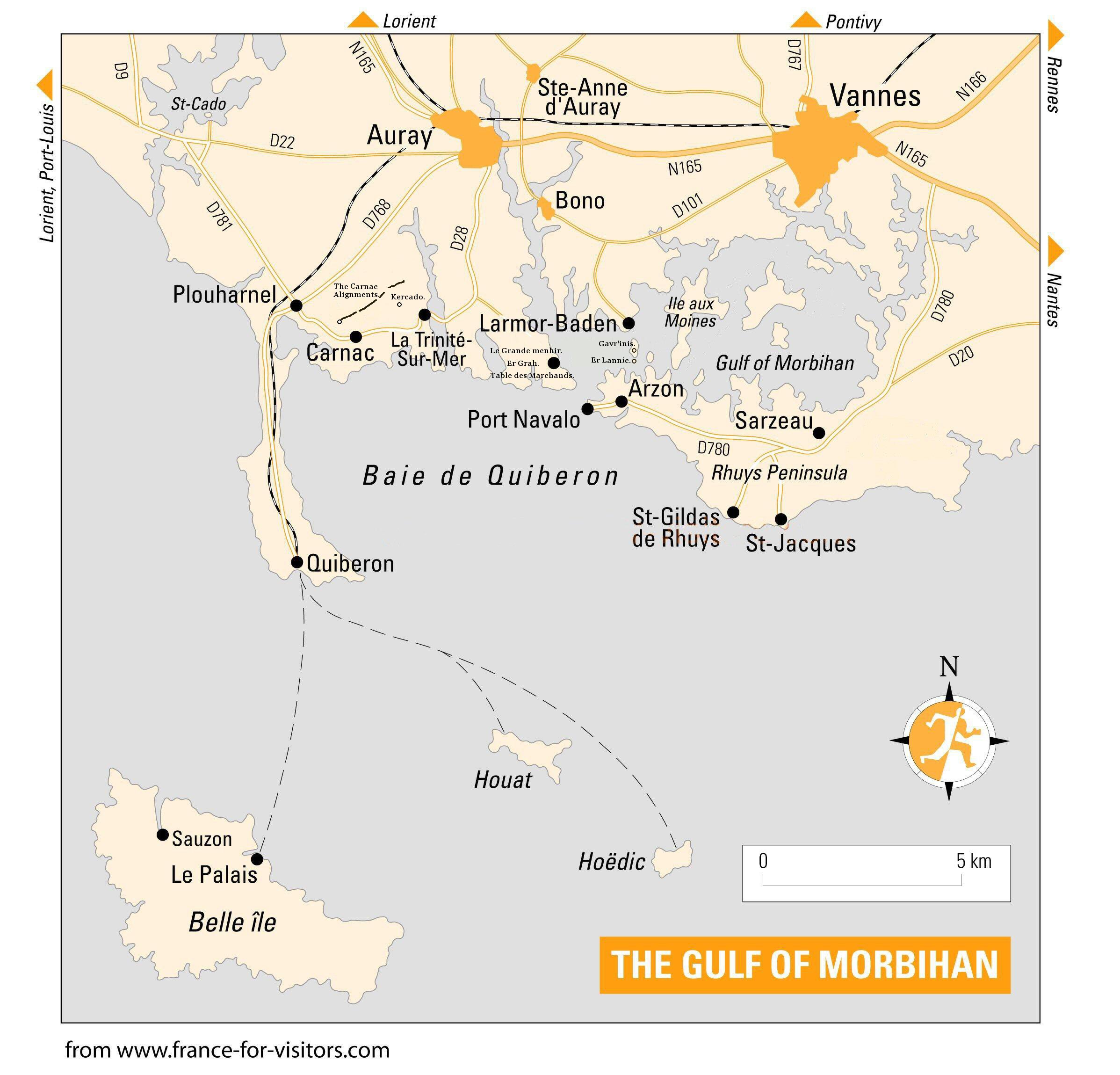
Location: Morbihan,
Brittany, France. |
Grid Reference:
47� 35' 52.08" N, 3� 3' 47.52" W |
 The Carnac Complex:
This particular region of France contains one of the highest concentrations
of megalithic activity in all Europe. It includes stone-circles, alignments,
dolmens, menhirs, passage-mounds and tumuli. The alignments are the largest
in the world, and are estimated to have once included over 4,000 stones (now
around 3,000).
There are have been
several distinct phases of construction at Carnac,
with roots that trace back to 6,850 BC.
(4)
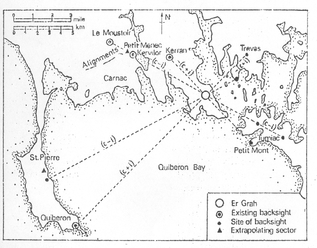
(Map of
Location)
Carnac is located at the unique latitude on the Earth at which the
solstice sun, both summer and winter, form a perfect Pythagorean triangle
relative to the parallel of latitude, that is to the east-west, equinoxial
axis of the site. In turn, this 3:4:5 triangle is the first of the
Pythagorean triangular set and is expressed in the dimensions of the Crucuno
monument.
(8)
(More
about Quadrangles and their Latitude)
|
Overview
of the Site:
Carnac is one of the
largest megalithic complexes in
Europe, and while it is tempting to see the region as a collection
of separate sites, it should be recognised that an astronomical
connection between sites was established by Thom
(2), and that in the Neolithic
age the sea level in the area
was roughly 30ft lower than
it is today removing any physical barrier
between sites (such as Gavr'inis and Er-Lannic). The re-use of megaliths
in the area can be used to determine connections between
otherwise unrelated sites such as between the passage-mounds of Gavr'inis and La Table des Marchands for example, both
of which incorporated pieces of an earlier monument into their
structures (capstones) at around 3,100 BC.
For all the activity in the
area, it is noticeable that the region as a whole has a complete lack of Neolithic dwellings
which has forced some pre-historians to conclude that the centres of population may have existed
by the coast, which is below the current sea level.
Origin of name 'Carnac':
J. Michell
says that the site was named Carnac
after the Egyptian
Karnak by the Count Maudet de
Penhouet (1), although the 1864 survey
by M. Bertrand offers a different picture,
tracing the ' ac'
determination to the frequency of megaliths, suggesting that the name has
a common prehistoric root. The same determination is common in both
Irish, Welsh and Scottish place names where it is seen as 'ach'.
Chronology:
Carnac is home to some of the earliest
megaliths in Europe. It shows several distinct phases of
construction, denoted by the occasional re-use of existing
monuments. The following is a basic breakdown of the main
prehistoric construction phases at Carnac.
|
Charcoal from the St. Michel Tumulus (see
below) has been
Radio-carbon dated to 6,850 BC
(4).
The first major construction phase at Carnac
is at c. 4,500 BC as the following examples illustrate:
-
The Kercado passage mound, south-east of the Kermario alignment
produced
Radio-Carbon dates of 4,700 BC. The mound is
surrounded by a circle of stones and has a menhir on its peak. The entrance
of the chamber faces 32�
south of east, almost exactly towards midwinter sunrise.
(3)
-
The only relatively clear date for the alignments
is provided by the Manio Tumular bank, an early monument (5th millennium
B.C.) covered by the ends of the Kermario alignments, which must therefore
be considered more recent.
(5)
-
Le Grand Menhir alignment (and other parts of
Lochmariaquer site), have been dated at c. 4,500 BC
(6)
The second major construction phase is at c.3,300 BC as
the following examples illustrate:
-
Parts of Le Grand Menhir alignment are re-used as
capstones for La Table des Marchands (over an existing stone), Er-Grah,
and the Gavr'inis passage mounds.
-
The alignments at Carnac are believed to have been built
at this time. Burl indicates a date of around 3,300 BC with an error of
several hundred years
(7)
|
Astronomy:
Carnac is located at the unique latitude on the Earth at which the
solstice sun, both summer and winter, form a perfect Pythagorean triangle
relative to the parallel of latitude, that is to the east-west, equinoxial
axis of the site. In turn, this 3:4:5 triangle is the first of the
Pythagorean triangular set.
Several
researchers have determined that astronomy was an important factor in the
design of many of the structures in the Carnac complex. The site shows
several similarities with other western European 'complexes' such as the
Boyne Valley complex in Ireland, The Salisbury (Silbury
hill) complex in England or the
Orkneys complex in Scotland, all of
which are dated to the same approximate time, and all of which appear to
consider astronomy as a fundamental, if not the sole requisite of these
complexes.
(Archaeoastronomy) |
Construction techniques - The Carnac builders were clearly qualified
stone masons and as such they were adept at techniques such
as quarrying and splitting hard stone like granite, (which was the preferential stone for
the megalithic builders all across Europe). The following shots from Carnac
illustrate that the method used 5,000 years ago was similar to that used by
masons today.
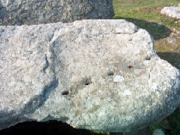
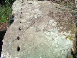
(Photos courtesy of Ken).
(Other Examples from around the Prehistoric World)
|
Featured Monuments at Carnac: |
|
The Seven 'Great' Tumuli.
 Hidden amongst the thousands of megaliths in the area are seven great
Tumuli, several of which extend over 100m in length, and rise to a height
averaging over 10m. These Tumuli have produced Radio-carbon dated goods from
dates as far back as 6,850 BC. (4), which makes them a fundamental part of
any prehistoric landscape at Carnac. Hidden amongst the thousands of megaliths in the area are seven great
Tumuli, several of which extend over 100m in length, and rise to a height
averaging over 10m. These Tumuli have produced Radio-carbon dated goods from
dates as far back as 6,850 BC. (4), which makes them a fundamental part of
any prehistoric landscape at Carnac.
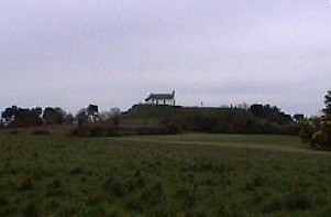
Tumulus St. Michel -
Their initial purpose of this mound was clearly funerary, as the sealed
stone cyst inside yielded large
numbers of finely crafted jadeite axe-heads and other precious goods such
as turquoise beads, alongside burnt human remains. It is interesting
to note that the Tumulus St. Michel was cardinally orientated at this early
time and was located so as to include small island long-sights both to the
east and west.
Carnac's patron saint is St Corn�ly, who is also the patron
saint of cattle, and a bull cult still lingers in the parish church on
tumulus St. Michel, which
'displays an image of the saint blessing two paintings of bulls surrounded
by menhirs and dolmens.
(1)
The roots of this cult can be traced back to the earliest finds in the
Carnac region at 6,850 BC
(4),
which coincidentally come from beneath the very same church.
(More about St. Michael) .
|
|
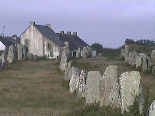
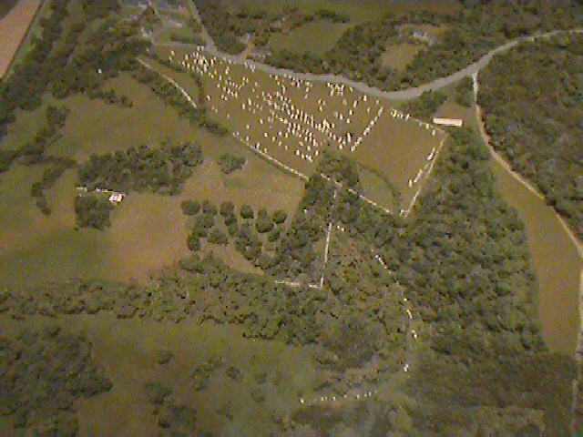
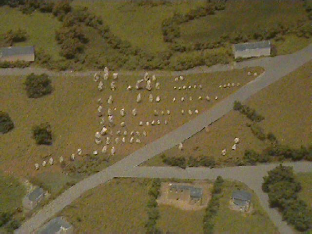
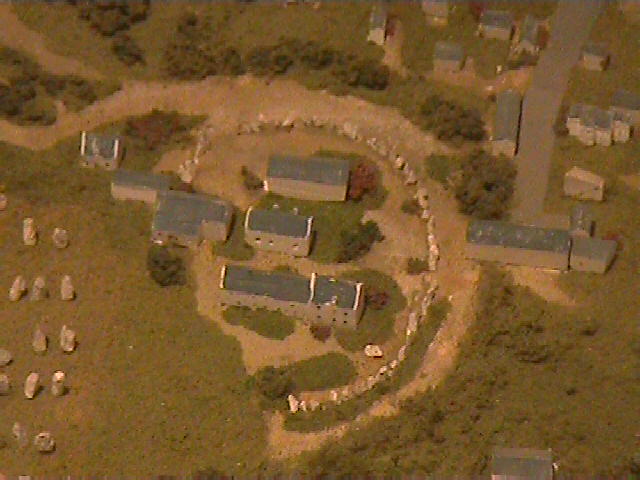
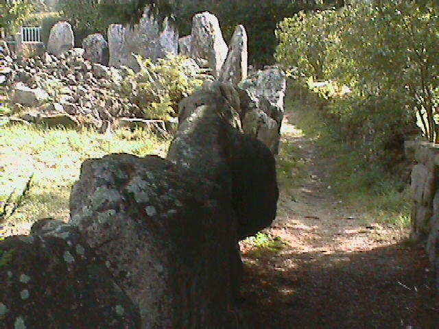
Les Alignments.
The four main alignments run east from the hamlet of Le Menec,
part of which lies within a large stone circle, which was determined by
Prof A. Thom to have been made with a geometric foundation. The alignments
are believed to have been erected at around 3,300 BC
(7).
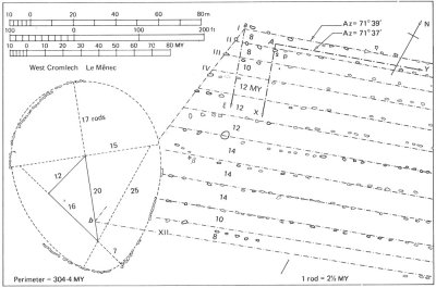
The alignments start at
the village of Le Menec,
with a large
circle of over 60 megaliths.
There are now only around 3,000 stones left in these
alignments but it is estimated that there were originally over 4,000.
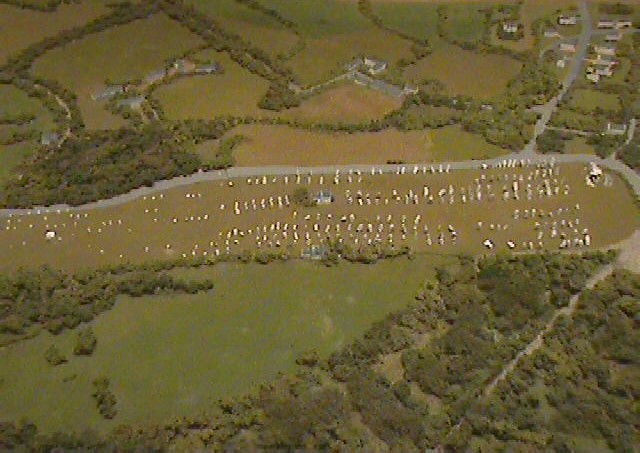
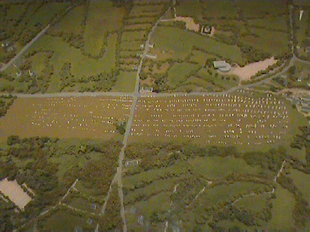
The main
alignments at 'Kermario' (left). and 'Le Menec' (right)
(Although there are only eleven rows visible
today, it has been determined that
there were originally twelve)
(1)
The 12 parallel rows
were
graded in height starting with the largest stones at the west (The village end),
decreasing in height until the alignment terminates at another 'egg-shaped'
circle. The stones are not only graded along the alignments, but across them too, which suggests a
substantial
amount of planning and preparation took place before the stones were
positioned - and that they were selected according to some criteria which we
can only now guess at.
Note - A large number of the
stones on these alignments have a red mark on them from a survey by Le Rouzic.
It is generally believed that this meant that he had raised these stone
back into place, but the exact meaning
of these marks was lost as he died before completing his papers.
The Menec 'Giant', which stands within 'Le Menec' alignment is believed
to have been a part of an earlier construction phase.
The next concentration starts again at Kermario 'The Place of the
Dead', with the distinctive passage mound between alignments. Again the
lines start with the larger stones first (Over 7m high), being graded
down in size as it continues eastwards.
The sets of alignments have 'elbows' in them, similar to
those seen in the Cursus' in England. The nature of these alterations in
orientation over their length is a subject of much debate, although it is
generally considered to be astronomical this has yet to be fully proven.
Changes in the orientation of Egyptian temples were shown by Lockyer to have
been caused by re-orientating in order to adjust for the slow movements of
the heavens such as that caused by the procession of the equinoxes.
The smaller 'Kerlescan' and 'Petit Menec' alignments.
Geometry not only in the form of circles, but also a rare
example of the 'stone-square' or rectangle at Crucuno.
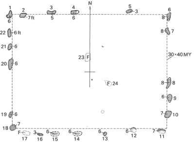
The Crucuno Quadrangle is one of a handful in
Europe which appear to show a relationship between their
latitude and their dimensions. Thom found Crucuno to measure 30
megalithic yards by 40 megalithic yards, creating a 3:4:5
triangle: The Stonehenge station-stones are proportioned
according to the second Pythagorean triangle at 12:13:15.
(More about Megalithic 'Quadrangles')
Other Alignments at Carnac.
Le Grand Menhir Alignment
- (Lochmariaquer) originally 19 menhirs. Now destroyed.
Keriaval - Several partial lines. Bad state of
repair.
Kerzerho - 1km SE of Erdevan. 2km long alignment
running NW to SE. 10 rows of over 1000+ stones.
The giants of Kerzerho: perpendicular to northern row at west end.
La Chaise de Cesar (Ceasers chair) - (2km SE of
Erdevan) - Runs NW to SE. stone circle at end.
St. Barbe - At least four rows, greatly plundered to
build the village.
St. Pierre de Quiberon - Associated with a stone
circle.
Vieux Moulin - (North of Plouharnel). Six stones in a
line.
(More
about Alignments)
|
|
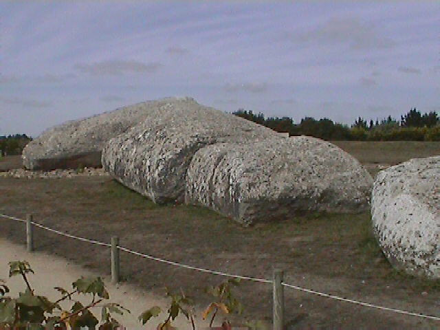
 Lochmariaquer: Lochmariaquer:
The
Lochmariaquer constructions as we see them today have a common
link through Le Grand Menhir, which has now fallen. The tumulus
of Er-Grah (cardinally
orientated) and La Table des Marchands (orientated to the summer solstice)
both show a re-use of existing monuments took place in the area at
around 3,300 BC as they both contain parts of one of the
original menhirs from the Grand Menhir alignment at
Lochmariaquer. This also represents a shift in thinking by the builders
who appear to have built structures at this time which were
predominantly orientated towards the sun instead of the moon.
|
|
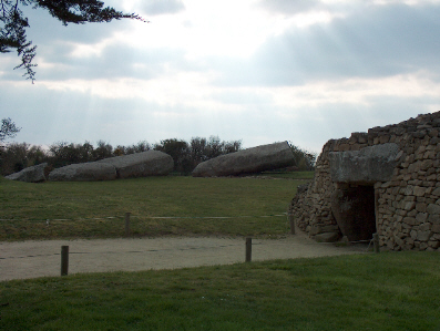
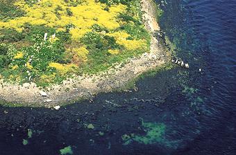
The Gavr'inis Passage Mound:
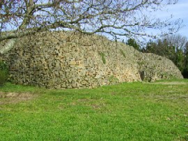 The
Gavr'inis passage mound has revealed several important clues
about the region. The capstone was once a part of a larger
stone, which was probably part of the great 19-stone alignment
at Lochmariaquer (and of which Le Grand menhir Bris The
Gavr'inis passage mound has revealed several important clues
about the region. The capstone was once a part of a larger
stone, which was probably part of the great 19-stone alignment
at Lochmariaquer (and of which Le Grand menhir Bris �
was the largest stone). We are firstly reminded that at the time
the mound was made (c. 3,300 BC), the water level in the area
was substantially lower than today and the route from one site
to the other would have been possible on foot.
We can see in
this particular construction phase that large existing monuments
was re-used for new large-scale constructions in the area, which
also included the alignments, and all the existing monuments at
Lochmariaquer. Within these monuments we can see a shift in
thinking from predominantly lunar orientations to solar. The
inside of the Gavr'inis passage mound has one of the richest displays of
Neolithic art anywhere in Europe. It has been noticed that there is a
similarity between the style of art at Gavr'inis and that in the
passage-mounds at the Boyne-Valley complex
in Ireland, which were built at the same time and which share a similar
orientation.
(More about Gavr'inis)
Other Passage mounds
in the Carnac area.
Kercado - Dated at 4,600 BC. This is the
oldest passage mound in the area.
La Table Des Marchands -
Built at 3,300 BC over the pre-existing end-stone.
(More
about Passage Mounds) |
|
Menhirs in the Carnac
area.
There are several large
menhirs in the Carnac area, not least of all is the 20m long menhir called
'Le
Grand Menhir Bris�'
(The large, broken stone), which now lies in four pieces where it
fell.
This last remaining stone is only one of an original 19, which appear
to have all been taken down and re-used elsewhere in the area at around
3,300 BC. In the 1980's, archaeologists determined that the capstones from Gavrinis, La Table des Marchands and Er grah, were all part of the same
stone, and one of the missing 18. There is speculation that the other 17
stones may still be one day located (perhaps also in pieces), and also
having been re-used for other constructions in the area.
Prof. A. Thom determined that
Le Grande Menhir Brise� was
positioned so as to be a giant lunar back-sight for several other nearby
locations.
(More
about Le Grand Menhir Bris �)
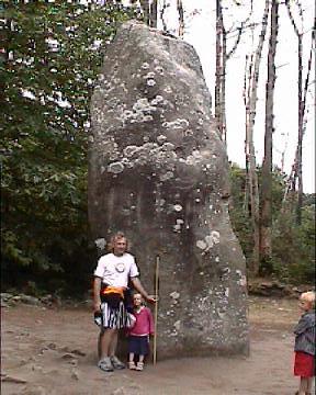
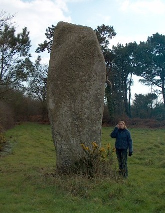
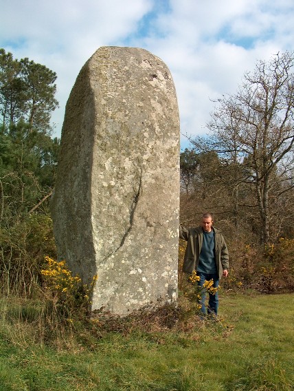
Some examples of the numerous menhirs at Carnac.
(More about French menhirs)
|
|
Les Stone circles (Cromleques):
There are still several visible stone circles in the area, including two
partially submerged circles on the small island of
Er Lannic, just beside
Gavrinis. It is now believed that there was
once a circle (or Cromleque) at the end of each of the main alignments.
Prof. Alexander Thom
determined that this circle was based on a 3,4,5 triangle, the sides being
15, 20 and 25 MR (also found in Britain).
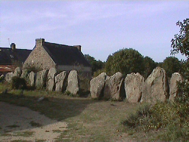
The stones define the outlines of gardens in a village
mostly built in the late 1800's.
Er-Lannic. (Twin circles) - The
twin circles of Er-Lannic are now partially submerged and are only visible
momentarily on the boat ride to Gavr'inis passage mound.
These circles have been dated to around 3,000 BC, they were
found to have several cup-marks, and the outliers (now submerged), suggest
an astronomical influence.
(More about Er-Lannic)
Other Stone circles in the Carnac area:
Kermario - Western end of the Kermario alignments.
Stone holes under present car park.
Crucuno - 2km north of Le Menec. 40-50m diameter
quadrangle.
Kercado - Tumulus with
surrounding stone circle. 35-40m diameter.
St. Pierre de Quiberon - Southern part of town. Stones
1.5m high. Associated with alignment.
Ile aux Moines - Island in Gulf de Morbihan with 3
dolmen a menhir and a 48 stone-circle.
(More about Stone circles)
|
(European Megalithic Complexes)
(Other French sites)
|
|