|
 Geometric Alignments:
Sir Norman Lockyer was one of the first modern
Europeans to identify the presence of an underlying geometry connecting
the alignments of ancient sites.
The ancient landscape was a canvas
upon which in prehistory, our ancestors connected points on the ground with points in the sky,
then further
reinforcing these connections with
megalithic constructions. Although simplistic, this is the essence of
the ley-line theory, which is still not fully accepted by the
scientific community. The suggestion of a further geometric connection
between these alignments has always been a bone of contention for
mainstream pre-historians, who still argue that Neolithic people were
simple tribal, hunter/gatherers, with only basic skills, and as yet
not identifying any presence of any order or hierarchy in their
society, which might facilitate the existence of such grand
architecture.
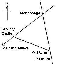
What is a 'geometric alignment'......'Analysis
of the Stonehenge triangle'...
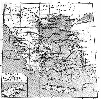
The equilateral triangle at
Stonehenge which was recognised
by Sir Norman Lockyer serves as an excellent means whereby many of the answers to
these questions can be found through the same example.
The sites identified by Alfred
Watkins in the 1920's that composed ley-lines in Britain included the
following:
Stone-circles,
mounds, Beacon points, cross-roads, dolmens, standing stones,
dew-ponds etc...
The marker points for the Stonehenge
triangle are: Stonehenge (Circle, Henge), Grovely castle (Grove-ley),
Old Sarum (Mound, Circle, Henge). All classic Watkinsian markers. Further
more, each side extends beyond the triangle, crossing more classic
Watkinsian markers.
(More about Ley lines)
|
 A
fundamental component in the Stonehenge-Grovely alignment is that it
is oriented along the azimuth of the mid-summer solstice sun.
This same alignment is continued physically in the shape of the
'Avenue' at Stonehenge. The astronomical significance of the specific
location of Stonehenge is also seen in terms of latitude, as it was
built under the exact azimuth of the maximum northerly setting for the
moon over its 18.6 year cycle. A
fundamental component in the Stonehenge-Grovely alignment is that it
is oriented along the azimuth of the mid-summer solstice sun.
This same alignment is continued physically in the shape of the
'Avenue' at Stonehenge. The astronomical significance of the specific
location of Stonehenge is also seen in terms of latitude, as it was
built under the exact azimuth of the maximum northerly setting for the
moon over its 18.6 year cycle.
The
alignment
extends to the North-East beyond St Peters
mound, Inkpen beacon, and the Neolithic 'Winterbourne camp'. To
the South-West the line continues past Grovely Castle, Castle
ditches and the 'Cerne-Abbas'
giant to Puncknowle beacon on the South coast.
The Stonehenge - Old Sarum line continues on to
Avebury (Silbury Hill), and can be considered to
be at least of the same age, as both Avebury and Old Sarum are dated
at 3,000 BC (6). Watkins believed that ley-lines terminated with a
beacon point which Silbury Hill and Old Sarum are both classic
examples.
The Stonehenge-Old Sarum line is continued
another 6 miles to the site of the present Salisbury Cathedral, then
the 'Clearbury rings' and 'Frankenbury'.
(More
about Old Sarum)
The last side of the triangle, from Grovely Castle
to Old Sarum however, shows little, if any significant extension in
either direction. The fact that both lie at the same distance from
Stonehenge, might better be explained by the actual distance between Grovely castle
and Old Sarum, as both of these locations are natural outcrops
protruding from the surrounding landscape, which raises the
interesting possibility that it was the distance between these two
landscape features which
played a part in determining the ultimate location of Stonehenge.
Although there is a huge range of dates for these
markers,
(i.e. we know that Grovely castle has Neolithic provenance
(8), and
that the major earth-works at Stonehenge began
at around 3,100 BC (5) it is possible to identify at least
another 3
sites along the Stonehenge - Grovely castle line that have Neolithic
provenance, offering a reasonable indication that the origin of this line in particular
can be dated to at
least 3,000 BC.
(More
about Stonehenge)
|
Prominent European Geomancers: |
Sir
Norman Lockyer
-
(1836-1920)
- Lockyer made the first 'professional' observation of geometry in the
lay-out of the ancient landscape. He realised that a geometric
connection existed between
Stonehenge,
Grovely (Grove-ley) castle and Old Sarum. The three form an equilateral
triangle
with sides 6 miles long.
(See Above)
Lockyer pioneered the field of archaeo-astronomy,
and spent some a time in Egypt, where he investigated the alignments and
orientations of many ancient structures. He was able to combine his
astronomical knowledge with observations at certain temples, and produce
dates that he confirmed through examples of temples with re-aligned axis.
His researches led him to conclude dates of 4,000 BC for early dynastic
structures
(3).
|
William Black
- In the 1800's, an expert
on roman roads called
William Black,
announced his theory that he had uncovered
a whole system of �grand geometric lines�, radial and polygonal,
which ran across Britain and beyond. He pursued his studies for fifty
years before releasing the theory. They linked major landmarks in a
precise manner, even defining the boundary markers of counties. Black
died in 1872. (Ref: Sacred geometry).
Note: A number of locations (i.e. Normandy/Brittany, Ireland,
France/Italy etc), still have dominant megaliths that seem to define
borders.
When the
boundary-line between Normandy and Brittany in
France was established, The pre-existing standing stone 'Dol-de-Breton'
became a natural boundary marker. Several ancient county
borders in England also used pre-existing megaliths to
define their boundaries. |
 Prof. Alexander Thom
- Prof. Alexander Thom
- Radically suggested that geometry was used in the design of certain prehistoric
sites. He surveyed hundreds of European megaliths and concluded that
fundamental mathematic principles, based upon a common unit of measurement which he called the
megalithic yard,
had been applied in the
design of certain sites. As the megalithic tradition in Europe can be traced
back to at least 4,000 BC, if not earlier still, his work is still not
accepted by many archaeologists, although such a strong presence of
mathematics should not be ignored, as it clearly suggests that the design of
many sacred sites seems to have been based on a very sophisticated
philosophy of sacred science such as was taught centuries later by the
Pythagorean school.
As
Professor Thom observes in his book Megalithic Sites in Britain
(1967):
�It
is remarkable that one thousand years before the earliest mathematicians
of classical Greece, people in these islands not only had a practical
knowledge of geometry and were capable of setting out elaborate
geometrical designs but could also set out ellipses based on the
Pythagorean triangles.�
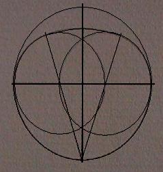
The Geometric alignments of standing stones Mid-Clythe,
Caithness. (After A. Thom).
(More about Alexander Thom and the Megalithic yard)
|
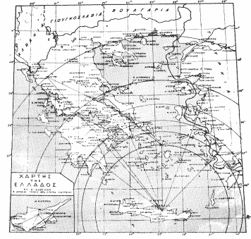
Xavier Guichard
France was the home to a
detective called Xavier Guichard, who in
the early 20th century, while investigating the ancient roots of place
names, discovered a prehistoric network of alignments extending throughout
France (and other areas of Europe). These alignments were connected by locations
with the name
Alaise. He also concluded that he had touched upon the
Eluesian
mysteries of ancient Greece.
Guichard's research
uncovered two giant 'Rose des Vents', one of which was divided 24 times and
had no astronomic significance, and the other one orientated towards the
rising and setting points of the equinoxial sun. The underlying geometry
suggests a division of the circle into units divisible by 24, (suggesting
the use of a 360�
circle), in addition to which, all of the several hundred ' alaisian'
locations were seperated by units of exactly one degree of either longitude
or latitude (also based on a 360�
circle). his strongly
suggests the awareness of longitude and latitude.
The implications of such a large-scale practical display of geometric
alignments forces
an investigation of his claims.
(Original
Copy of Eleusis Alaise)
It is noticeable that
Guichard reached similar conclusions over
the purpose of certain routes, and determined the same root-name
(Alaise-Leys), his work was entirely
independent of his contemporary researcher in England, Alfred Watkins who's work on 'Ley-lines' appeared
to confirm that such practices had existed in Britain too.
(More about Xavier Guichard) |
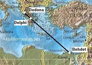
Livvio Stecchini - Suggested that the ancient
oracle
centres were placed according to geodetic principles at which 'Omphalus'
or 'Navel stones' were placed. This idea is supported by the
historical narratives of Herodotus, who wrote
that the oracle centre of Amon in Libya was founded by flying doves from
Thebes, which was long considered the geodetic centre of ancient Egypt, is
located 2/7ths of distance from the equator and the north pole, and at which
an Omphalus was later discovered. Herodotus also wrote that the oracle
centre at Dodona was said to have been founded by Egyptian priestesses from
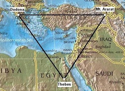
Thebes and that doves flew between the two sites. Dodona was believed by the
Greeks to have been the resting place of the ark, and it is interesting to
note that two doves are often associated with Omphalus. The
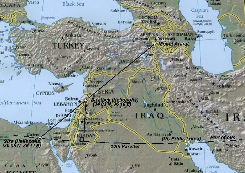
Hebrews believe that the final resting place of the ark was at Mount Ararat
in Turkey, which is on the exact same latitude as Dodona, and the three form
an equilateral triangle.
Robert Temple, later continued Secchini's work, suggesting that the separation of the oracle centres, each
by 1 �
of latitude, created an 'oracle octave', from which the seven
major centres were placed, each devoted to one of the seven known planets,
and symbolised by different sacred trees and letters (for more on this
subject, refer to the tree alphabet in R. Graves book 'The
White Goddess', and this, he
believed formed the basis of the 'Eleusian
mysteries'
The idea that ancient Greek temples and sacred
locations were located according to mathematical was explored
extensively by (Th. Manias? Via *By Antonis T. Vasilakis), who believed that �each
of the different enormous cities built around the globe by our
ancestors, the Minoans (before the existence of any form of civilization
in Egypt), was a geodetic landmark of a colossal system of annotation
for each geographical longitude, with the most ancient being the centre
of the Omphalic Field of Knossos, (�until�) the grand disaster of
which took place in the second half of the 16th century B.C�
(Extract from 'TA
AGNOSTA MEGALOYRGIMATA TON ARHAION HELLINON' by
Th. Manias)
  Knossos (Left), Dodona and Delos
(Right). From Manias (7)
(More about the Eleusian Mysteries)
(More about the Oracle Centres)
|
John Michell Began by researching stone circles in Cornwall, through which he began to
recognise a the presence of common units of measurement, and geometric
connections between megalithic sites.
First brought to the public attention the
existence of the now famous 'St Michaels' ley-line and also revealed in
�City of revelation�,
the existence of a
large scale geometric figure 'The
Decagon' across southern Britain. The ancient Celtic
�perpetual choirs� at Llantwit manor, Glastonbury Abbey and Stonehenge were
shown to be 'three vertices of a regular decagon of majestic proportions.
A fourth vertex exists at Goring-on Thames where a major pagan temple once
stood at the junction of several important track ways'. The centre of
the decagon is at the apparently insignificant hamlet of Whiteleaved Oak
where the former counties of Hereford, Gloucester and Worcester came
together. This decagon is related by angle and distance to the other
geomantic centres of Britain.
 Note: Michael Behrend
supported Michell's original concept but made two small changes to the
original scheme. At present, no more than Note: Michael Behrend
supported Michell's original concept but made two small changes to the
original scheme. At present, no more than
three
vortices can be shown have a substantial enough accuracy and
significance, although
their
distance and angle from each other certainly appears to be accurate
enough to suggest the possibility of a deliberate, rather than
incidental placement.
(More about 'The Decagon')
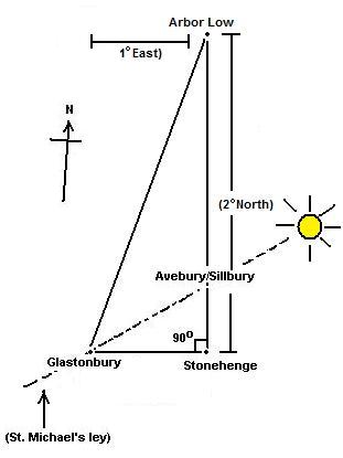
The discovery of a
geometric relationship between
Glastonbury and
Stonehenge
inot unique. The
two sites are also associated with several other ancient structures in
Britain (such as the right-angled triangle formed with the inclusion of
Avebury/Silbury
(Arbor Low). The
strong astronomic and sacred
nature of these sites is reminiscent of
Lockyer's earlier theories concerning the alignment of such sites, and it is
tempting to conclude that such factors resulted in a geometric relationship.
However, such a synthesis
by no means precludes the idea that geometry itself was the original factor
that determined the location of the sites. It is therefore interesting
to note that the 'Decagon' is centred on the border of three counties
(Whiteleaved Oak), which
(apart from the 'sacred' name), has no reference to either astronomy or religion.
(Prehistoric
British Geodesy)
|
Chris Street
- (http://earthstars.co.uk)
- Revealed in his book 'Earthstars', the existence of a series of
underlying geometric alignments
connecting London's ancient landmarks, and even
extending beyond. Significantly, many of the sites identified combine to
produce two concentric circles that surround London. The proportions of
these circles are the same as those found in the geometric pattern described as the sacred proportions for the city of
'New Jerusalem', the 'holy city of revelations' (as decreed by St.
John). It is also interesting that the same geometric pattern is
repeated in the ground-plan for
Stonehenge, which has
numerous other geometric associations itself.
The observation of the same
pattern at both sites is compounded by the fact that it is the same one
produced by 'squaring the circle' in
sacred geometry, which
results in the proportion otherwise known as the 'sacred mean', as seen
throughout nature, (such as the relationship between the distances and
dimensions of the Earth and the Moon).
(Geodesy
Homepage)
Livvio Stecchini suggested that the many of the ancient oracle sites
were placed according to geodetic principles. A suggestion which
implies a working knowledge of longitude and latitude.
 A milestone of
literature on the subject of the geodetic placement of oracle centres
already exists, written by Livio Stecchini
(22),
who concluded that several ancient oracle centres in the Mediterranean
and Middle-east, were deliberately placed along specific latitudes and
separated by units of 1�, which he suggested composed an 'oracle
octave', along which the seven major centres were placed, each
devoted to one of the seven known planets and symbolised by different
sacred trees (for more on this subject refer to the 'Tree alphabet'
in R. Greave's book, 'The White Goddess'). Underlying this
geodetic placement, he believed was a set of knowledge that that
formed the basis of the 'Eleusian mysteries'. A milestone of
literature on the subject of the geodetic placement of oracle centres
already exists, written by Livio Stecchini
(22),
who concluded that several ancient oracle centres in the Mediterranean
and Middle-east, were deliberately placed along specific latitudes and
separated by units of 1�, which he suggested composed an 'oracle
octave', along which the seven major centres were placed, each
devoted to one of the seven known planets and symbolised by different
sacred trees (for more on this subject refer to the 'Tree alphabet'
in R. Greave's book, 'The White Goddess'). Underlying this
geodetic placement, he believed was a set of knowledge that that
formed the basis of the 'Eleusian mysteries'.
(More about the Eleusian Mysteries)
The connection between 'sacred' Egyptian sites and the Greek oracle
centres is supported by mythology. Herodotus wrote that the
Oracle centre of Dodona was established from Egyptian Thebes (Karnak).
As well as the fact that both Dodona and Ararat (Metsamor),
lie on the same latitude and are both equidistant from Thebes,
they are both also reputed to have been landing places after the great
Flood events.
(More about Oracle Centres)
|
Egyptian Geometric Alignments: |
There have been several suggestions of geometry
between ancient Egyptian sites.
Important Egyptian temples were placed according to
geodetic principles, which demonstrate a clear knowledge of a
spherical world at the same time as showing that the Egyptians used
the same Babylonian and Sumerian system of a division of 360�.
.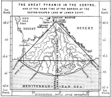
It can be seen that
Giza, Alexandria
and Behdet (The ancient capital), form a triangle with an angle of 51�
51' (The same as the Great pyramid and the angle of summer solstice
sunrise at Stonehenge) The
distance between them, and therefore the eastern and western borders
of ancient Egypt was 1� 09', the same as the distance between the
Greenwich and Paris meridians.
Beyond Giza:
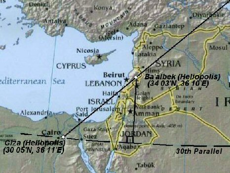
The placement of Giza
(Heliopolis)
along the 30th parallel
(along with other sacred sites such as Persopolis, Sumerian Larsa and
Tibetan Lhasa at 60� east of Giza), demonstrates a recognition of geometry and is a
clear example of deliberate placement of ancient sacred sites. It can
also be seen that the early dynasty Egyptian pyramids were orientated
towards Heliopolis (Click here for
more), it is therefore relevant in relation to this that
Giza (Heliopolis), is almost exactly
4� west and 5� south of
Heliopolis (Ba'albek), in Lebanon,
creating an angle of 45�.
The
division of
21�
36' (3 x 7� 12') between Giza and Persopolis is said
by Stecchini to be due to the following expression
((7�
12� x 5 = 36�) x 10 = 360�). This
is the same distance that defines the Northern and Southernmost limits
of ancient Egypt (i.e. first Cataract 24� 00' to Behdet, Alexandria 31�
12').
Nimrud,
the Assyrian religious capital (875BC), was placed almost
exactly 6� North and 12� East of Giza.
Nimrud -
(36� 06� N, 43� 20� E).
As well as
being exactly 6� North of the Giza
complex, Nimrud shares another remarkable mathematical
parallel to another Egyptian feature, which is that the
longitude of Nimrud is the exact same angle as that used for the
exterior of both of Snoferu�s pyramids (43�
20' / 22').
This is not an isolated coincidence, but rather one which can
also be seen at Silbury hill,
England, which not only sits on the same latitude (51� 24.8' N)
as the
exterior of Menkaure's pyramid, but simultaneously reproduces
the latitude of Giza in its own exterior angle of 30� and marks
the point 4/7th's the distance from the equator to the North
pole. When viewed in consideration of the placement of
Karnak at 2/7th's and
Delphi at 3/7th's, the placement
of these significant ancient sites appears to suggest a larger
pattern of deliberate placement.
(More about Egyptian Geodesy)
|
Examples of Large-scale Geometric Alignments.
|
Shape |
Location |
Discoverer |
Select |
|
Equilateral triangle |
Salisbury, England |
Sir N. Lockyear |
View |
|
'Decagon' |
England-Wales |
J. Michell |
View |
|
Right-angled Triangle |
Middle East |
Personal observation |
View |
|
Equilateral triangle |
France |
M. Chattelain |
View |
|
2x Rose de Vents |
France |
Xavier Guichard |
Viev |
|
Heptagon |
Wessex, England |
Chrichlow (1) |
View |
|
Squaring the circle. |
London, England |
C. E. Street (2) |
View |
|
Multiple |
Oracle centres |
Livvio Stecchini |
View |
|
Equilateral triangle |
Southern England |
Personal observation |
View |
|
Equilateral triangle |
England-France-Ireland |
Personal observation |
View |
|
Right -angled Triangle |
Southern England |
Personal observation |
View |
Note: The 'heptagon' above has been
discerned as embracing Wessex, however, the two most southern points would
only have been on dry land before 6,000 BC (1)
Ilkley Moor Triangle
- Three stone circles form an equilateral triangle on Ilkley Moor, being
separated by exactly 1,180 yards each. They are: The Twelve Apostles, The
Blackstones and The Grubstones. Flashing lights and other curious phenomena
have been reported several times over The Twelve Apostles.
(4)
|
|