|
 Navigation:
(Prehistoric Methods of Navigation)
Navigation:
(Prehistoric Methods of Navigation)
Navigation Methods
in Prehistory.
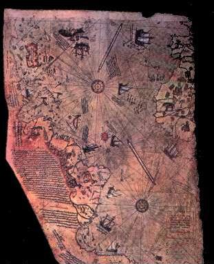
Potentially one of the most
significant finds in modern time. The Piri-reis map (right) shows both the
American coastline and demonstrates the early use of longitude and latitude.
The key to the map states that sections of it originate
from the time of Alexander the Great, a statement which clearly suggests
that such knowledge was available at that time.
(More
about the Piri-reis map)
In addition to this, there are several other solid pieces of evidence that demonstrate
the existence of a set of navigational skills existed in prehistory
as the following examples show:
|
Navigation in Prehistory: |
Navigation from one location to another relies on a means of
calculating direction. The following methods are some of the better
known methods.
Cellestial navigation:
Probably the oldest form of navigation is that carried out
with the use of the
stars at night, and the sun during the day. This form of navigation
requires a simple knowledge of the movement of the heavens. For example:
-
Both the sun and the moon can be used
to determine direction.
-
Polaris is a good indicator of north.
-
Polaris can be used to
determine latitude.
-
Observation of eclipses can
determine longitude.
The Phoenicians looked to the heavens. The sun moving across the commonly
cloudless Mediterranean sky gave them their direction and quarter. The
quarters we know today as east and west the Phoenicians knew as Asu
(sunrise) and Ereb (sunset), labels that live today in the names Asia and
Europe.
Ley-lines: In
his book, The long Straight Track, Alfred Watkins proposed that ley-lines
were used by prehistoric people as to travel along for trade amongst other
uses. Stones and other significant monuments were placed along their length.
Peruvian straight-lines have the same function, as do the Aboriginal
Tuaringas in Australia.
(More about Leylines)
Magnetism: Certain
animals such as pigeons are known to use the earths magnetic field for
navigation, the extraordinary navigational skills of birds have been
recorded for millennia, and could well have been applied as a navigational
aid.
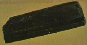
1 ,000 B.C.
-
It has been established that
this object (34 x 9 x 4mm), was part of a larger bar. It has been polished
on each face, and has a groove running 'approximately and possibly
intentionally parallel to the edges' along one of the flattened-faces.
If its function was to serve as a directional finder (as is commonly
supposed), the longer its original length, the more accurate the reading
would have been. Under experiment, it repeatedly provided a consistent
bearing (to within 1/2�), using a 'stadia-rod' at 30m.
This naturally magnetic square metal fragment (M-160)
points 35.5� West of magnetic
North (when made to float). It was found in an Olmec mound in Vera Cruz,
Mexico.
Several examples of naturally magnetised statues
have been found at other south American sites, noticeably in
Guatemala where carvings of figurines and animals were designed with
the magnetised sections in the navels and temples of the figures.
How such magnetic properties were first identified in the stone
remains a mystery.
(More about Magnetism in
Prehistory)
The Chinese Navigators.
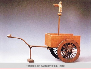
The above is a Chinese invention which
through a system of gears always pointed the direction �home�. The little
sage atop the centre post points toward the origin of the journey no matter
how many turns and changes in direction the cart has taken�
 2,000 B.C
- 'Emperor Wang-Ti
placed magnetic figures with an extendable arm to the front of carriages.
Apparently they pointed South'. (Ref: Ignatius Donnelly: Atlantis) 2,000 B.C
- 'Emperor Wang-Ti
placed magnetic figures with an extendable arm to the front of carriages.
Apparently they pointed South'. (Ref: Ignatius Donnelly: Atlantis)
The similarity between the two objects
described suggests that they are both one and the same.. which description
is correct is a matter of conjecture.
( More
about Prehistoric China)
(More about Magnetism in
prehistory)
Navigation at sea:
The
first seafarers kept in sight of land; following the coast. One could line
up landmarks, such as a rock against a distant point on land; doing that in
two directions at once gave a more or less precise geometric location on the
surface of the sea. Sounding using a lead and line also helped. "When you
get 11 fathoms and ooze on the lead, you are a day's journey out from
Alexandria," wrote Herodotus in the fourth century B.C. The Greeks even
learned to navigate from one island to the next in their archipelago, a
Greek word meaning "pre�minent sea". They may have followed clouds (which
form over land) or odours (which can carry far out to sea).
"Crete is believed to have been colonized by migrant farmers from
Anatolia as early as the eighth or seventh millennium B.C., although
hunter-gatherers surely landed there earlier. Broodbank and Strasser
have shown that the colonization of this island must have been
deliberate and that a minimum number of people and livestock were
required to sustain its initial population� The earliest human
presence is recorded at stratum X at Knossos, almost two thousand
years before any other human presence in the Aegean� the distances are
significant and certainly entailed the usage of stars for orientation
at night�thus it is not surprising that seafaring, including
navigation and its offshoot, astronomy, took root here very early�.
(D. Davis. 2001)
The
Piri-Reis map: Potentially one
of the most significant finds in
modern time. The Piri-reis map (c. 1513), shows the coastlines of the American continent. It also includes the outline of the Antarctic
continent which has been frozen over since around 4,000 BC. This map alters all
previous conceptions of our pre-historic ancestors abilities. The 'Piri-Reis' map (c.
1513). is one of several 'portellano's', which appear to have a
geometric basis of unknown provenance. This map has many
interesting features, such as:-
The map has
pre-Columbian provenance.
The map shows the coastline of America.
The map shows accurate use of
Longitude and Latitude.
The map-builders used 'Spherical geometry'.
The centre of the map is at
the junction of the 23.5˚
parallel and the longitude of Alexandria.
The cartographers of the Piri-reis map used a system called the
12-wind system, which was used extensively in the middle ages and has
its roots in the Babylonian sciences.
(More
about the Piri-reis map)
Polynesian Navigation:
Heeding
the flight-paths of birds was just one of numerous haven-finding methods
employed by the Polynesians, whose navigational feats arguably have never
been surpassed. The Polynesians travelled over thousands of miles of
trackless ocean to people remote islands throughout the southern Pacific.
Like Eskimos study the snow, the Polynesians watched the waves, whose
direction and type relinquished useful navigational secrets. They followed
the faint gleam cast on the horizon by tiny islets still out of sight below
the rim of the world. Seafarers of the Marshall Islands built elaborate maps
out of palm twigs and cowrie shells. These ingenious charts, which exist
today only in museums, denoted everything from the position of islands to
the prevailing direction of the swell.
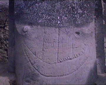
This massive statue from
Easter island was buried up to the chest. When uncovered it revealed this
image of a sailed ship.
The ancient Polynesians
navigated their canoes by the stars and other signs that came from the ocean
and sky. Navigation was a precise science, a learned art that was passed on
verbally from one navigator to another for countless generations.
In 1768, as he sailed from Tahiti, Captain Cook had an additional passenger
on board his ship, a Tahitian navigator named Tupaia. Tupaia guided Cook 300
miles south to Rurutu, a small Polynesian island, proving he could navigate
from his homeland to a distant island. Cook was amazed to find that Tupaia
could always point in the exact direction in which Tahiti lay, without the
use of the ship's charts. Sadly, Cook was never able to learn and document
Tupaia's navigational techniques, for Tupaia, and many of Cook's crew, died
of malaria in the Dutch East Indies. Unlike later visitors to the South
Pacific, Cook understood that Polynesian navigators could guide canoes
across the Pacific over great distances.
But these navigational skills, along with the double canoe, disappeared with
the emergence of Western technology, which mariners the world over came to
rely on. In 1976, the Hokule'a', a replica Polynesian double canoe made by a
team of Hawaiian canoeists, voyaged from Hawaii to Tahiti using the ancient
navigational techniques of their ancestors. Ben Finney, a member of the
team, explains their mission: "Since by the 1960s Polynesian voyaging canoes
had disappeared and ways of navigating without instruments had largely been
forgotten, those of us who objected to Heyerdahl's ...negative
characterizations of Polynesian voyaging technology and skills ...concluded
that we would have to reconstruct the canoes and ways of navigating, and
then test them at sea, in order to get at the truth."
Using no instruments, the canoe team navigated as their ancestors did, by
the stars. They had no maps, no sextants, no compasses, and navigated by
observing the ocean and sky, reading the stars and swells. The paths of
stars and rhythms of the ocean guided them by night and the colour of sky and
the sun, the shapes of clouds, and the direction from which the swells were
coming, guided them by day. Several days away from an island, they were able
to determine the exact day of land fall. Swells would tell them that there
was land ahead, and the surest telltale sign would be the presence of birds
making flights out to sea seeking food. By sailing from Hawaii to Tahiti,
Hokule'a's team was able to prove that it was possible for Polynesian
peoples to migrate over thousands of miles from island to island.
(The
Prehistoric Pacific)
Article: Possible Prehistoric Navigation
Tools (06-Oct-2001)
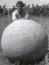 On
Dreamland September 6, 2001, Ivar Zapp and George Erikson discuss a
remarkable new theory of ancient navigation that is based on a group of
mysterious stone spheres in Costa Rica. The alignment of these spheres
implies the existence of a complex and world-girdling navigation system
that must date from very ancient times. On
Dreamland September 6, 2001, Ivar Zapp and George Erikson discuss a
remarkable new theory of ancient navigation that is based on a group of
mysterious stone spheres in Costa Rica. The alignment of these spheres
implies the existence of a complex and world-girdling navigation system
that must date from very ancient times.
The spheres themselves have been described by
archaeologists as "out of context," meaning that they do not fit
established patterns of construction and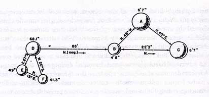 architecture seen in the area. No attempt has ever been made to explain
them or date them.
architecture seen in the area. No attempt has ever been made to explain
them or date them.
Zapp and Erikson, however, have studied not only these
spheres, but enigmatic ruins around the world, and are proposing a theory
that they are the totally unexpected but very sophisticated navigational
tools.
(5)
Viking Navigation
The Norsemen had to have
other navigational means at their disposal, for in summer the stars
effectively do not appear for months on end in the high latitudes. One
method they relied on was watching the behaviour of birds. A sailor wondering
which way land lay could do worse than spying an auk flying past. If the
beak of this seabird is full, sea dogs know, it's heading towards its
rookery; if empty, it's heading out to sea to fill that beak. One of the
first Norwegian sailors to hazard the voyage to Iceland was a man known as
Raven-Floki for his habit of keeping ravens aboard his vessel. When he
thought he was nearing land, Raven-Floki released the ravens, which he had
deliberately starved. Often as not, they flew "as the crow flies" directly
toward land, which Raven-Floki would reach simply by following their lead.
Article:
Mail-Online (November, 2011) Norse Navigators may have
located the sun with crystal Feldspar.
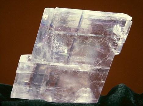
'Ancient legends
of Viking mariners using mysterious sunstones to reveal the position
of the sun on a cloudy day may well be true, according to a new
study. While experts have long argued that Vikings knew how to use
blocks of light-fracturing crystal to locate the sun through dense
clouds, archaeologists have never found solid proof. Vikings, they
argue, used transparent calcite crystal - also known as Iceland spar
- to fix the true bearing of the Sun to within a single degree of
accuracy. The naturally occurring stone has the capacity to
'depolarise' light, filtering and fracturing it along different
axes, the researchers explained. The recent discovery of an Iceland
spar aboard an Elizabethan ship sunk in 1592 - tested by the
researchers - bolsters the theory that ancient mariners were aware
of the crystal's potential as an aid to navigation. Even in the era
of the compass, crews might have kept such stone on hand as a
backup, the study speculates. 'We have verified that even only one
of the cannons excavated from the ship is able to perturb a magnetic
compass orientation by 90 degrees,' the researchers wrote. 'So, to
avoid navigation errors when the Sun is hidden, the use of an
optical compass could be crucial even at this epoch, more than four
centuries after the Viking time.' The study appeared in Proceedings
of the Royal Society A: Mathematical and Physical Sciences, a
peer-reviewed journal published by Britain's de facto academy of
science, the Royal Society.'
(4)
(More
about Crystal use in Prehistory)
|