|
 The Piri-Resi Map:
(Prehistoric Cartography)
The Piri-Resi Map:
(Prehistoric Cartography)
|
P otentially one
of the most significant finds of
modern time as it is clearly dated 1513 AD and shows both the coastlines of the American and
debatably, the Antarctic coastline (which has been frozen over since around 4,000 BC). This map alters all
previous conceptions of our pre-historic ancestors abilities. The 'Piri-Reis'
map is one of several 'portellano's' which appear to have a
geometric basis of unknown provenance. It has several
interesting features which deserve investigation, such as:-
The map has
pre-Columbian provenance.
The map shows the coastline of America.
The map shows accurate use of
Longitude and Latitude.
The map-builders used 'Spherical geometry'.
The map centres at
the junction of the 23.5˚
parallel (Tropic of cancer), and the longitude of Alexandria.
|
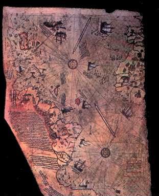 |
In 1929, a section of a world map drawn by the Turkish Admiral Reis
(Piri-reis), was found in the basement of a museum in
Constantinople. The map was of immediate interest as it appeared to
show the coastlines of South America and Africa at their correct
relative longitudes and latitudes, and the legend on the map dated
it to 'Muharran' in the Moslem year 919 (1513 AD), only 20
years after the official discovery of the Americas by Columbus in
1492. The legend on the map itself however, gave it an origin far
older than 20 years, revealing that it was a section of a world map
composed from more than twenty source maps, some drawn in the time
of Alexander the great, and that 'some were based on
mathematics'
(4).
The fact that there was no known means of accurately calculating
longitude in 1513 AD led Prof. Charles Hapgood to examine the map
further.
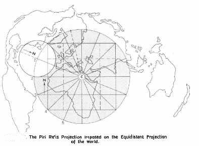
Hapgood's research led him to make several fundamental conclusions;
Firstly, he confirmed that the coastlines of the continents had been
accurately plotted with regards to both latitude and
longitude. Secondly, he determined that the co-ordinates had
been mathematically converted from natures spherical model to fit
the two dimensional representation of a map, (a method similar in
principle to Mercator�s projection). Thirdly, he showed that a
connection existed between this map and several other ancient
portolano�s and mappa-mundi, some of which included the
outline of the Antarctic continent.
These facts led Hapgood to suggest the existence of a set of
knowledge from a time before the Greeks, and placed a question mark
over the origin of sciences such as geometry, geography and
cartography, traditionally accredited to the Greeks.
The presence of a Mercatorial projection on such old maps is
significant as such high levels of geometry had not been seen since
the time of the Greeks and it was not until the work of Gerald
Mercator in 1569, that European�s began to include a
projection for the curvature of the earth into their maps. We can be
fairly sure that the inclusion of such a projection was not the work
of Piri-reis, as he left several cartographic errors of his own
(such as skewed sections of coastline, and the duplication of
the Amazon river), which testified to the fact that the Piri-reis
map is actually a montage of other maps, and he admitted
himself that his world map was �composed with the use of other
source-maps' which therefore already included the
projection. An association of such knowledge even as far back as
the Greeks, is in itself, an achievement worthy of merit.
We can see that the horizontal lines on the map are geographically
(and astronomically) significant, with the Equatorial line sitting
correctly between the Tropics of Cancer and Capricorn, both of which
are also marked with �Rose des vents�. The inclusion of
vertical lines marking the correct longitudinal separation between
the African and South American continents identifies the map as
having a cylindrical projection, a feature which is not seen
on maps before this time, or for another fifty years until Mercator
presented his map to the world. This identification of the Tropics
within the geometry of the map confirms the suspicion that a
knowledge of astronomy was available to the original cartographer,
who also used the Tropic of Cancer to mark the geographic centre of
the map
(4).
The calculation of latitude is a relatively easy procedure requiring
only a single observation of the height of the sun from the horizon,
the length of a shadow or the height of the pole star in the sky,
whereas the calculation of longitude is a more complicated
figure to deduce. It is because of this that off-shore navigation
was for a long time at best educated guesswork (dead-reckoning),
a situation which became an anathema to the European scientific
community for several hundred years, managing to elude some of the
greatest scientific minds of the time (Galileo and Newton included),
and it was not until 1760 that success was eventually realised in
the shape of a precision ships-clock or chronometer, and
world maps were re-charted accurately, and apparently for the
first time. The development of such a timepiece meant that if a
sailor reset a ships-clock at noon each day, and compared the
difference between that clock and another unadjusted clock from a
known longitude, the difference between the two could be translated
into longitude (as each four minutes of difference between the two
clocks translates into a single degree of longitude).
Apart from the possible exception to the Antykithera find, which may
have functioned as an �astrolabe', the Greeks were known to
have calculated longitude with the use of astronomy, as did several
other cultures in history. A record from 14th century
China states that �Wang Da Yuan achieved a transoceanic passage
from Mozambique to Sri Lanka using a combination of compass and star
linked positions called gouyang Qianxing to determine latitude and
longitude�
(28).
We know that this level of astronomy was not generally available in
the west, and a workable means of calculating longitude was
apparently still not known in
Europe
at 1540 AD, when the German astronomer Johanes Werner first proposed
using the moon as a location indicator
(19). (If
an eclipse is predicted at a location at a certain time and one
experiences the eclipse an hour earlier, then one knows that they
are positioned 15 degrees east of their original location). While
this system works well in the presence of an eclipse, their
infrequency makes them impracticable as a method for sailors to use
�on demand�, and relies on an accurate reading of the time of
eclipse at both locations.
Apart from the fact that the map is dated at 1513 AD, long before
the discovery of such an accurate method of calculation, Piri-reis
himself states in the legend that it was a composite of several
older maps, including some drawn �in the days of Alexander, Lord
of the Two Horns..�, some ��Arabic Jaferiyes�� and one
�...drawn by Columbo in the western region�. With regards this
latter contribution from Columbus, he adds that ..
��it is reported thus, that a Genoese infidel, his name was Columbo,
who discovered these places. For instance, a book fell into the
hands of the said Columbo, and he found it said in this book that at
the western end of the Western sea (Atlantic) that is, on its
western side, there were coasts and islands and all kinds of metals
and precious stones. Columbo having studied this book thoroughly,
explained these matters one by one to the Greats of Genoa��
(4).
We therefore have several suggestions that this map at least,
includes a set of knowledge that predates the European renaissance
of the sciences which followed the intellectual vacuum of the
�Dark-ages� under the shadow of the �Holy church of Rome� (a time
when science was rejected as witchcraft and the world was believed
flat). If it is the case that all the continents of the world were
accurately charted onto a world map before this time, it would be an
historic achievement and worthy of recognition in its own right, and
it is the very presence of one of the continents that has generated
the most debate. The coastline of the Antarctic continent appears
accurately on several ancient maps although it has
been covered by several miles of ice-pack from a time long before
the Greek empire and the first officially recognised world map by
Ptolemy in 150 AD.
(19).
'Terra Australis Incognita'
The Antarctic coastline (Terra Australis Incognita):
 The recognition of the Antarctic continent on certain ancient
world-maps may well turn out to be Hapgood�s most significant
discovery as, apart from the fact that there is no record of anyone
ever having charted the continent, it is a feat said by geologists
to have been last physically possible only through a window of
opportunity between 10,000 BC and 4,000 BC
(4),
a date that was arrived at through analysis of core samples taken
from the Ross sea-bed, which established that sub-tropical flora and
fauna were present on Antarctica during these dates, and following
which a severe climatic shift resulted in the region freezing over.
The conclusion of this fact is that the cartographers of the map
would have had to have charted that region no later than 4,000 BC, (before
the coastline froze over). The recognition of the Antarctic continent on certain ancient
world-maps may well turn out to be Hapgood�s most significant
discovery as, apart from the fact that there is no record of anyone
ever having charted the continent, it is a feat said by geologists
to have been last physically possible only through a window of
opportunity between 10,000 BC and 4,000 BC
(4),
a date that was arrived at through analysis of core samples taken
from the Ross sea-bed, which established that sub-tropical flora and
fauna were present on Antarctica during these dates, and following
which a severe climatic shift resulted in the region freezing over.
The conclusion of this fact is that the cartographers of the map
would have had to have charted that region no later than 4,000 BC, (before
the coastline froze over).
The presence of the Antarctic continent on the Piri-reis map
is in debate, with suggestions that the bottom tip of the south
American continent was simply �squeezed� on, following a
miss-judgment in size by Piri-reis. Regardless of this, there are
other ancient maps which clearly do have the outline of the
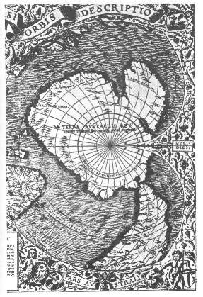
continent on them, with both Gerard Mercator's map of 1569 AD
and the Oronteus Finaeus map of 1532 AD (right), also showing the
coastline, and the Hadji Ahmed map of 1559 AD, which not only
has Antarctica with a correct Mercatorial projection but also shows
a land bridge between the Bering straits, re-enforcing the
suggestion of an antiquitous origin. The specific division of the
Antarctic continent into two smaller land-masses on these ancient
maps is similarly a mystery as it was only at the end of the 20th
century that we were finally able to determine (through satellite
technology) the accurate outline of the Antarctic continent, which
was found to be identical to those seen on some of the oldest
surviving maps of the world.
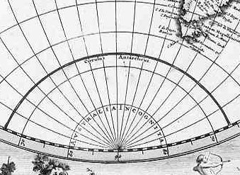
Hapgood�s research led him to identify another feature common to
several ancient maps which was that the Antarctic continent
occasionally appears greatly enlarged with details along the
coastline remaining consistent to scale. It was through this
particular finding that Hapgood realised that the line called the 'Circulus
Antarcticus' which appears on maps at this time was the same as
the 80th parallel on modern maps (made with a Mercatorial
projection), and he suggested from this that the original maps had
been made with a Mercatorial projection and divided into units of 10
degrees from a division of the globe into 360�, he then concluded
that this original map was then later copied without realising that
it already contained a mathematical compensation for the loss of
curvature, which without a proper understanding of the lines on the
map, resulted in an exaggeration of the land mass by around 4 times
its actual size.
There are several significant implications attached to the discovery
of
Antarctica
on such old maps. In particular, the use of longitude, along with
its conversion onto a two-dimensional representation implies a
knowledge of a round world, and the determination of both the poles
and equator provides the information necessary to calculate the size
of the Earth. In addiction, the first recorded sighting of 'Terra
Australis' was by Magellan in 1520, appearing on the Oronteus Finaeus
map of 1532 (above). The inscription on the 1570 map by Ortelius 'Terra
australis recenter inventa sed nondum plene cognita', suggests
that the landmass was still essentially unknown at that time,
as does the 1688 map below.
However unlikely it seems therefore, or until new evidence emerges,
we are forced to accept that
any
world map including an accurate representation of the Antarctic
coastline would have had to have been charted before the last time
it froze over, and therefore from a source as
yet unknown, and with the radio-carbon evidence from the Ross-sea core-samples
showing
that the continent has been covered by ice since around 4,000 BC, it
is closer to this period in time that we are forced to look.
Other Maps of the Antarctic
continent.
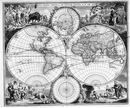
This 1688 world map illustrates the level of ignorance in Europe at
that time.
D uring his investigation, Hapgood
came to realise that several other ancient maps (such as the
Dulcert Portellano of 1339 AD), also appeared to display
evidence of longitude and latitude, and included the same
mathematical lines of projection known as the �Twelve wind
system�. His researches led him to compare ancient �portelano�
maps with several mappa-mundii which emerged in the
middle-ages, concluding that many of them were 'almost unaltered
copies of the same original'
(4).
The connection between the Piri-reis map and Constantinople led him
to speculate on the possibility that the map may have had its roots in
the store-house of knowledge, libraries etc that existed
there until the 12th century when the city was sacked by
the Christian crusaders, and following which a series of maps with
an identical geometric fingerprint, began to
appear in Europe and the Middle-east. The presence of the same
fingerprint in certain Greek maps and the information in the legend
of the Piri-reis map that it included sections composed in �the
time of Alexander�, led him to suggest that these originals
must in turn have originated from the renowned Library of Alexander
(founded in 330 BC and sacked by the Muslims in 641 AD).
As we know that the outline of the South American continent hadn�t
been completely charted by 1513AD, we are safe in assuming that
Columbos contribution of his map of the
Caribbean
islands most likely served as a confirmation to Piri-reis when he
made his map. He would also had had available to him a strong
Middle-eastern tradition of astronomy and geometry with records of
longitude from the Middle-east stating that in �1267 the Arab
astronomer Zamaruddin built the first wooden global sphere with
latitudes and
 longitudes and correct ratio sea/land of 70/30�
(28).
Further east, there is evidence that longitude was understood and
used by the Chinese slightly ahead of this, with the concept of
longitude shown to be understood at least as far back as 1092 AD, as
shown in the star chart published by a Chinese mechanical engineer
of the Son Dynasty called Su Song, (right), which includes
a �Mercatorial� projection of the heavens. We also have the
evidence of a carved map from 1137 AD, which shows the outline of
China at its correct longitudes and latitudes and a record from the
14th century, that �Wang Da Yuan achieved a
transoceanic passage from Mozambique to Sri Lanka using a
combination of compass and star linked positions called gouyang
Qianxing to determine latitude and longitude�
(28).
From the same source, we are offered a map of the world from a
Chinese called Zeng He, drawn in 1418 AD (with a meridian at
Nanjing), but even the earliest Chinese records appear long after
the time of �Alexander the Great�, and Hapgood�s theory of a common
source from the time of the Greeks must be taken seriously. longitudes and correct ratio sea/land of 70/30�
(28).
Further east, there is evidence that longitude was understood and
used by the Chinese slightly ahead of this, with the concept of
longitude shown to be understood at least as far back as 1092 AD, as
shown in the star chart published by a Chinese mechanical engineer
of the Son Dynasty called Su Song, (right), which includes
a �Mercatorial� projection of the heavens. We also have the
evidence of a carved map from 1137 AD, which shows the outline of
China at its correct longitudes and latitudes and a record from the
14th century, that �Wang Da Yuan achieved a
transoceanic passage from Mozambique to Sri Lanka using a
combination of compass and star linked positions called gouyang
Qianxing to determine latitude and longitude�
(28).
From the same source, we are offered a map of the world from a
Chinese called Zeng He, drawn in 1418 AD (with a meridian at
Nanjing), but even the earliest Chinese records appear long after
the time of �Alexander the Great�, and Hapgood�s theory of a common
source from the time of the Greeks must be taken seriously.
We can see that the Greeks had the technical ability to create such
a map, with records of a knowledge of a spherical earth from
Pythagoras of Samos (580-500 BC), and the first definite known use
of longitude in the great �Geographica� world atlas made by
Claudius Ptolemy in 150 AD. Although Ptolemy�s work was lost for
over a thousand years, a copy without maps surfaced around
1300 AD, and the thousands of references to place names, most of
which included coordinates, enabled re-creations of Ptolemy�s maps
to be made, with printed copies on sale in Bologna by 1477 AD,
making it likely that Admiral Reis made us of these for his world
map. Sobel (19), states that Ptolemy was known to have used both
longitude and latitude for the 27 maps of his first world atlas, and
although she mentions that 'Lines of latitude and longitude began
criss-crossing our worldview in ancient times, at least three
centuries before the birth of Christ', she offers no further
information to qualify this statement.
The legend on the Piri-reis map states that several maps from the �days
of Alexander� (356�323 BC), were used to compose the map, and
although Ptolemy lived around 200 years after Alexander, it is well
known that he, for example, relied greatly on the authority of
earlier sources for his maps
(19),
with references to
�Marinos
of Tyre�
having been cited in Geographica by Ptolemy himself, which
might explain why he broke from tradition, and placed his zero
longitude 'meridian' through the 'Fortunate Isles'
(Canary Isles), along the western edge of Africa, as only one other
person before him had; the aforesaid Marinos of Tyre, from Lebanon,
who placed his zero latitude at approximately 36� N, sending it
directly through the straits of Gibraltar and into ancient Nimrud
(36� 06� N). We can see however that other earlier eminent Greek
cartographers such as Eratosthenes (276�194 BC), who was appointed
as librarian of the Alexandrian library in 236 BC, and who is known
to have used all the material available to him to create a world map
to correct the Greek perception of the world at his time, used
Alexandria for his meridian. He also used only 60 degrees of
separation called Hexacontades, with the Babylonian division
of a circle not being officially introduced to Greece until the
second century BC by Hipparcus of Rhodes (190�120 BC).
|
Name of Cartographer |
Zero Longitude |
Zero Latitude |
|
|
|
|
|
Eratosthenes (236 BC) |
Alexandria |
Alexandria |
|
Marinos of
Tyre |
Canary Isles |
Nimrud (36� 06� N) |
|
Ptolemy (150 AD) |
Canary Isles |
Equator. |
|
Mercator |
London (0�) |
(23�
30' N) |
The fact that the centre of the map changes with each cartographer
offers us a means of being able to determine more about its origin.
As the Piri-reis map was found to centre in the region of Syene,
along the same longitude as Alexandria (founded in 332 BC), it would
suggest that the original cartographer had an affinity with this
particular longitude, as did Eratosthenes, the maker of the earliest
recorded Greek world map, who also made the first accurate
calculation the circumference of the world. It is strongly suspected
that he was assisted in these accomplishments through the
availability of earlier knowledge collected and housed in the
Library of Alexandria. We now turn to the centre of the Piri-reis
map which, as it turns out not only holds the key to its own origin,
but at the same time points to a fundamental historical moment of
human endeavor, one that has hitherto passed unrecognised.
Although only the left-third of the map now remains, the remaining 'Rose
des vents' on the map enabled Hapgood to project for the
cartographic centre (see below), which was calculated to fall in 'the
region of Syene', in Egypt, and following a series of more
accurate tests he determined that the centre of the map was situated
on the ancient Tropic of Cancer, and on the same Meridian as later
Alexandria (at 30� longitude).
Centre of Piri-reis map - (24� 06� N, 30� 00� E)
This particular latitude has a significance as it was in Syene, on
Elephant island that there existed a large well which was known to
Eratosthenes to have cast no shadow on the midday summer solstice.
Even at the time of Eratoshtenes this fact was no longer true due to
the change in angle of the solstice shadow over time. In fact, at the time of
Eratosthenes (276 BC - 194 BC), the Tropic of Cancer was around 23� 43� N , and the region
of Syene, or Aswan, which is situated
at 24� 5' 23" N, would have only worked in
the way described at around 3,000 BC (See
calculation below).
|
Latitude of Aswan (Syene, Swenet) - 24 5' 23"
Tropic of cancer today (2000 AD) - 32 26' 22"
(Tropic currently decreasing by 0.47" per year -
(ref Wilkipedia)
Distance in degrees between Aswan and current
tropic = 39' or (2,340")
2,340 / 0.47 = 4978.7 yrs (approx 3,000 BC)
|
The
fact that the map centered on the region of Syene is of great
interest, as we know that Eratosthenes was aware of the significance
of this latitude in his estimates of the earth, and strongly
suggests that he was privy to Egyptian knowledge of geodesy and
astronomy.
Eratosthenes knew that on the summer solstice at
local noon in the Ancient Egyptian city of Swenet (known in Greek as
Syene) on the Tropic of Cancer , the sun would appear at the zenith,
directly overhead. He also knew, from measurement, that in his
hometown of Alexandria, the angle of elevation of the Sun would be
1/50 of a full circle (7�12') south of the zenith at the same time.
Assuming that Alexandria was due north of Syene he concluded that
the distance from Alexandria to Syene must be 1/50 of the total
circumference of the Earth.
(http://en.wikipedia.org/wiki/Swenet)
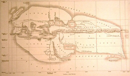
It is clear from the 19th cent. reproduction of Eratosthenes map (below) that the Piri-reis map
shows no similarity to it whatsoever. However, it is interesting to
note that while Alexandria marks the centre point on the map, it is
the latitude of Syene which is used to denote the latitude of the
tropic of cancer (note on left margin). It seems then, that he too
used a latitude with an
astronomical significance which no longer applied at his time.
There have
been several suggestions that geodetic measurements were observed in
Egypt before the Greeks, and it is possible that Eratosthenes had
some of this available to him.
Strabo the
Geographer, stated that �the science of
land-measuring originated along the Nile in Egypt', from a
necessity to record the boundaries of the nomes (provinces) of the
country, and it is suspected from the placement of sacred Egyptian
cities and shrines that a knowledge of the earth as a globe, its
dimensions and a division into 360�, existed in ancient Egypt, as
seem in the Piri-reis map but not by Eratosthenes, who
divided the globe into 60 divisions
(of 6�).
In conclusion then, what we appear to have in these ancient maps,
are copied fragments of earlier maps based on a 'sophisticated
understanding of the spherical trigonometry of map projections'
(4),
which, by their own testimony trace back at least to the time of
the Greeks, but with a suggestion that certain facts and figures may
have been passed down to them from the Egyptians and other sources.
They are clearly the result of a deliberate and successful exercise
at mapping the world, and as yet, the presence of the Antarctic continent on
any map before the 16th century has yet to be explained, as does the
high level of mathematics and geometry involved in such an
undertaking.
Ancient Cartography ۞
Egyptian Geodesy
(Prehistoric
Turkey)
|