|
Location: Mainland
Orkneys, Scotland. |
Grid Reference:
59� 00' N. 3� 00' W. |
 The Orkneys:
(Megalithic Complex).
The Orkneys:
(Megalithic Complex).
The Orkneys complex has been seen for a
long time as a separate cluster of megaliths. However, it is now realised
that several of the megalithic sites are connected, forming a prehistoric
ceremonial landscape.
The stark landscape of the Islands also offers a unique backdrop for these
beautifully constructed sites, against which they take on an ethereal
quality, as the builders must have been aware.
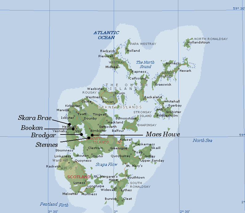
(Click here
for Orkneys map)
There are several
prominent megalithic sites on the Orkney Islands. The availability of
such good quality local stone gave these megaliths a unique
quality which still remains today. Until now there has been little solid
evidence for dating the sites. This year (2008), Renfew's 1973 trenches
were re-opened at Brodgar, and a series of samples have been sent for
radio-carbon dating (4).
We await the results.
Who were the builders
of the Orkneys megaliths?
It is suggested
that because the the two stone circles have henges that were dug
from the living rock, that the builders may have introduced this
technique from elsewhere, such as England where vast henges were
dug, but usually into soil.
The Neolithic
immigration of the Orkneys began around 3,500 BC.
There are
several features of the primary Orkneys megaliths which have
similarities to other Megalithic structures from further south
in Europe (i.e. Ireland, England, France), with all have
similarly orientated passage-mounds, Henges, Stone-circles
suggestive of astronomical observation. Also the structures
themselves show strong cultural similarities through art,
technique and design. At present, these people are commonly
referred to as the 'Beaker-people', or 'Boat people' from the
Neolithic period. A trend for migration along the western coast
of Atlantic Europe can be seen from southern to northern with
the Orkney complex representing the northerly most example of
socio-astro-religious civil-scale constructions.
Recent archaeology at the
'Ness' of Brodgar have revealed
that the Orkneys placement of the monuments into the landscape
shares similarities with the 'ritual' landscape at Stonehenge.
It has been proposed by archaeologist Mike Pearson that the
landscape represents the division between the world of the
living and the world of the dead. 
Suggestions
that the Neolithic megalith builders were closely connected with
the Irish passage mound builders, for example can be seen
through the art, construction and preference for
orientation.
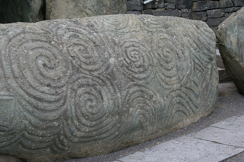
This beautiful mace-head (right), was
found at Knowth. The flint
itself comes from the Orkney
islands, which are by no means the nearest source of flint
to the Boyne valley. It is one of several clues that testify to
a cultural exchange between these two important megalithic
complexes, along with the style of art, exterior and interior
similarities in design of the passage mounds (Maes
Howe) and a strong astronomical theme underlying the
development of the structures.
(Prehistoric
Irish/Scottish/French connections).
|
Maes Howe Passage Mound:
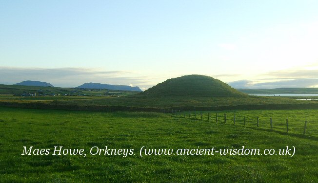
Maes Howe was carefully constructed to allow the winter solstice sunlight
to enter the passage, entering the inner chamber for several minutes only
each year. The sun shines into the chamber for a few minutes each year before
it passes behind the Hill of Howe, re-appearing for another few
minutes before setting between the two hills.
Meas Howe should not be viewed as an
independent structure. It was an integral part of the
prehistoric landscape, as the photo above illustrates. The
whole area can be seen as an outdoor ceremonial arena, with
the ever-present Hills of Hoy in the background receiving
the midwinter sun and marking the new year.
(More about Maes
Howe)
|
|
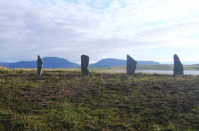
Stones of Stenness
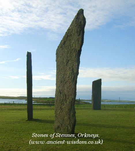
View from Stennes across the artificial causeway.
Although it is
difficult to see, the 'Watch-stone', the 'Ness' of Brodgar and the Ring of Brodgar
are all visible in this photo.
(Watch-stone
between centre and right stones, Brodgar left of left-hand
stone)
There were once
two 'watch-stones' at the entrance to the causeway and
archaeologists are currently in the process of uncovering
the complex between across the causeway, believed to have
once been a 'ceremonial' walled complex separating the sites.
(More about the Stones of Stennes) |
|
The Ness of Brodgar.
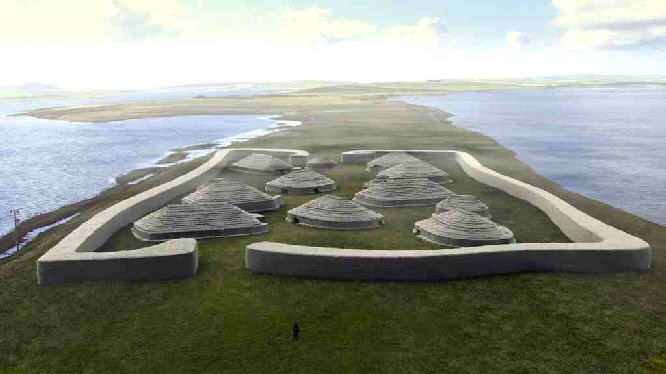
This walled
enclosure is currently being revealed by archaeologists. It
separates the Stones of Stenness from the Ring of Brodgar making
it essential part of the landscape. It is now
realised that the site is composed of as many as 100 structures,
with several vast, complex, and beautifully constructed
buildings)
(More about the Ness
of Brodgar)
|
|
The Ring of Brodgar.
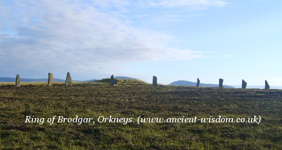
From the centre of this, the second largest circle in Britain, it can be seen how a mound was deliberately
built at the same place the sun set behinds the left-hand Hill of Hoy on the
winter solstice. This attempt to replicate the horizon can be seen in several
other megalithic sites in Scotland where it is also generally associated with
astronomical observation.
(More about the Ring
of Brodgar)
|
|
Skara Brae: A Priestly centre?
Skara Brae was built by the coast, in a beautiful
bay facing the setting sun. The 'village' lies in line with the great circles of
Bookam, Brodgar and Stennes which are now realised to have been part of a
ceremonial route, through what must have seemed a most sacred landscape through
Neolithic eyes. The position of Skara Brae at the end of such a significant
grouping of monuments combined with discoveries inside offers the possibility
that the structures (and inhabitants) may have even been a part of the
ceremonial process.

The overall layout of Skara Brae has several
design factors which suggest a specialised function, such as 'workshops',
a room lockable only from the outside..?? and the discovery of several hoards of
precious items hidden in the walls of the chambers (such as 2,400 inscribed
beads and pendants in one find alone).
(More about Skara Brae)
|
|
Archaeoastronomy on the Orkneys: |
At the latitude of the Orkneys the
major lunar standstills north becomes almost
circumpolar, (neither rising nor setting - with the effect that
the moon 'rolls' along the horizon). Because the Earth�s axial
tilt has changed by nearly half a degree since the majority of the
stone circles were built, this effect is no longer accurate and the
latitude today would have to be 63� north for a lunar standstill
north to be truly circumpolar
(5), while a truly circumpolar
Moon would have been visible on the Orkneys at around 3,500 BC.
Maes Howe:
The entrance to the Maes-Howe
passage-mound is orientated towards the setting winter solstice sun
behind the prominent Hills of Hoy in the distance. The chamber was
placed so that for several days before and after the winter
solstice, the sunlight flashes directly into the passage not once,
but twice, with a break of several minutes between each
illumination.
The passage is aligned facing
Southwest, facing Ward Hill. For 20 days before the solstice and for 20 days
after the solstice, the sun shines into the chamber twice a day. Every 8
years Venus causes a double flash of light to enter the chamber. This last
happened in 1996 and will happen again in 2004. �At around 2.35 p.m. on the
winter solstice, the sun shines on the back of the chamber for 17 minutes,
and then sets at 3.20 p.m. At 5.00 p.m. the light of Venus enters the first
slot, lighting the chamber, and then at 5.15 p.m. it sets behind Ward Hill.
But 15 minutes after its first setting, Venus reappears beyond Ward Hill,
and the light enters the chamber for a further two minutes, before setting
for a second and last time�. (16).
A series of measurements and
alignments have been taken which connect the Maes Howe Tumulus with
the Ring of Brodgar revealing a common unit of measurement.
In a direction 60� south from
the centre of the Ring of Brodgar at a distance of 63 chains is the
'Watchstone' (18ft high), 42 to 43 chains further on in the same
line is the 'Barnstone', (15 ft high). At the same distance of 42 or
43 chains to the north-east of the Barnstone is the tumulus of Maes
Howe.
The Ring of Brodgar is a
stone-circle which originally consisted of 60 equally spaced
megaliths. The Stones of Stennes was originally a stone-circle
consisting of 12 equally spaced stones. The numbers of stones used
for the circles is suggestive of base-6 mathematics, the same base
upon which all time and space was measured in the ancient
middle-east
Burl makes note of the 'mistaken
coincidence' in connection with this fact. He says of it:
'From Brodgar, where there was once 60
stones, to the Stripple stones with a probable thirty, the builders may have
counted in multiples of six.
Stennes had twelve. The inner and outer
rings at Balfarg have been computed at twenty-four and twelve respectively.
Twenty-four has been suggested for Cairnpappel, thirty-six for
Arbor Low, and
the same number for the devils quoits'.
(3)
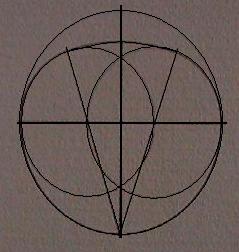
Thom radically suggested that geometry was used in the
design of certain prehistoric sites. He surveyed hundreds of European
megaliths and concluded that fundamental mathematic principles, based upon a
common unit of measurement (which he called the
megalithic yard),
had been applied in the design of certain
sites. As the megalithic tradition in Europe can be traced back to at least
4,000 BC, if not earlier still, his work is still not accepted by most
archaeologists, although such a strong presence of geometry should not be
ignored, as is clearly suggests that the design of many sacred sites seems
to have been based on a sophisticated philosophy of sacred science such as
was taught centuries later by the Pythagorean school.
As Professor Thom observes in his book
Megalithic Sites in Britain
(1967):
�It
is remarkable that one thousand years before the earliest mathematicians
of classical Greece, people in these islands not only had a practical
knowledge of geometry and were capable of setting out elaborate
geometrical designs but could also set out ellipses based on the
Pythagorean triangles.�
(More about prehistoric geometry)
|
Comparisons with other European Complexes: |
There are several noticeable similarities between
the megalithic structures of the Orkneys, and those found at other
contemporary European complexes. In particular, there are some distinct
examples of art and design which appear common to the Irish passage
mounds, such as those of the Boyne Valley. The discovery at Knowth of a
stone axe-head from the Orkneys confirms this relationship.
There are several fundamental similarities
between the Orkneys 'ceremonial' complex and other contemporary
complexes along the western Atlantic coast. In particular, the Orkneys
provides a perfect example of the two essential components of many
complexes; a prominent mound and circle in close proximity to each
other. The mound, which can be seen as the 'primal hill', is often
realised in the form of a passage mound although regional variations
exist such as at Avebury/Silbury.
On the Orkneys, the
monuments were constructed so as to merge with the landscape, in such a
way that the stones compliment their backgrounds. The same sensitivity
is seen at other megalithic sites, but nowhere is it realised quite so
well as on the Orkneys. The creation of these large-scale civil
constructions represents a form of higher communication between
ourselves and the universe we live in. Their intimate connection with
the living landscape into which we place them connects us to the earth,
and their invariable orientation towards Solar and Lunar events brings
us into time, with the visibly beating heart of the universe.
Other Similarities:
Both
Gavr'inis in France and
Newgrange
in Ireland were built at around the same time as Orkneys
monuments (c. 3,100 BC).
Along with Maes Howe, they all have
their passages aligned to mark the winter solstice. (Close to the Moons
eastern major standstill). This single alignment offers the potential
for the realisation of the Metonic cycle.
(More about
Prehistoric Astronomy)
As well as astronomical orientation,
the Maes Howe passage mound has several specific construction
features which are common with other European passage mounds, such
as their rounded shape, lowered passageway with raised internal
chambers, cruciform chambers, stone libation bowls and an absence of
contemporary funerary remains.
The theme of a Mound and Circle
together is also repeated at Neolithic Complexes across Europe.
(Similarities Between European
Passage Mounds)
The interior floor-level of both
Gavr'inis and
Newgrange were raised towards the
centres. At Newgrange, the upwards-sloping passage narrows the beam of
light into a thin strip. In fact, the only light that would have
originally been able to enter the internal chambers would have come
through the 'light-box', above the
passage entrance.
Light-boxes are a megalithic construction feature
that have so far only been recorded at three (possibly four) sites in
the UK, with two in Ireland (Newgrange
and
Carrowkeel
- see below) both having the
same design, and the other two on the
Orkneys in Scotland.
This particular connection is very specific.
(More
about Light-boxes)
Spiral Art.
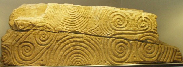
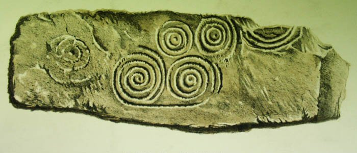
The 'Westray Stone', from Pierowall
(left). The Eday Manse stone, Isle of Eday.
(right).
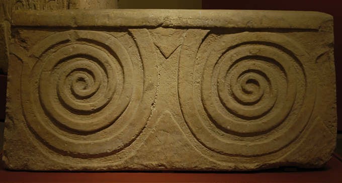
Bugibba, Malta, (Left),
Newgrange,
Ireland (right).
(More
about Spirals)
(Stenness)
(Brodgar) (Maes
Howe) (Ness of Brodgar)
(Skara Brae)
(Neolithic Complexes: Similarities between European Sites)
(Sacred Landscapes)
(Other Scottish Sites)
|