The Hill of Tara, known
as Temair in Gaelic, was once the ancient seat of power in
Ireland � 142 kings are said to have reigned there in prehistoric and
historic times. In ancient Irish religion and mythology Temair was the
sacred place of dwelling for the gods, and was the entrance to the
otherworld. Saint Patrick is said to have come to Tara to confront the
ancient religion of the pagans at its most powerful site.
Tara Hill is currently in the news because of the controversial
development of the M3 bypass which is literally cutting the ancient
landscape in half..
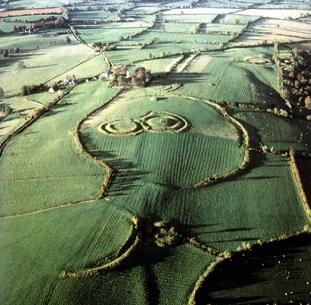
Tara Hill: ('Teamhair na R�', "Hill of the Kings").
Tara Hill was one of the most venerated religious spots
in early Ireland and the seat of the High Kings of Ireland from the 3rd
century until 1022 AD. Despite its importance, and compared to other
prehistoric Irish sites, at Tara there are no signs of regal past, nor
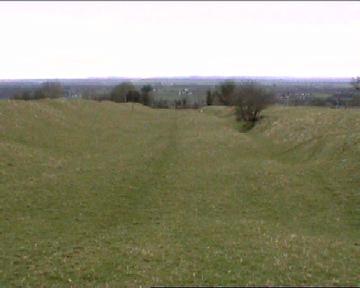
impressive remains, only the remains of earthworks.
In fact, this
small cluster of megaliths represents a single component of an extended
prehistoric landscape which would have provided the ability to
recognising specific moments of the lunar and solar cycles throughout
the year. In the case of Tara, the chamber of the 'Mound of hostages' is
aligned to mark the November 8th and February 4th, quarter days
(along with
Dowth and Cairns L and U at
Loughcrew). Tara is only 10 miles
distant from The
Boyne Valley complex, which is
clearly visible from there.
In the News:
The landscape around Tara Hill is
currently (2008) being desecrated through the shameful and unimaginative
development of the M3 Motorway extension which is being driven through
the Tara valley, destroying numerous prehistoric sites in the process,
and denying future generations to the chance to make a more informed
decision.
The development of the M3 Motorway through the Tara-valley has led
to its entry into the World Monuments Fund's 2008 Watch List of the 100 Most
Endangered Sites in the world.
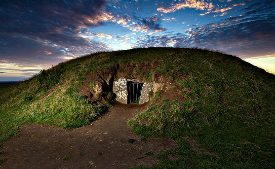
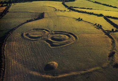
Tara Hill Constructions.
The 'Mound of the
Hostages' - The most prominent and oldest monument on the hill is the
Mound of the Hostages,upon which stands the 'Stone of
destiny' (below). The Mound of Hostages dates back to the
Neolithic period and is contemporary with the
Boyne Valley structures
(1).
Tara Hill was one of the most venerated
religious spots in early Ireland and the seat of the High Kings of Ireland from
the 3rd century until 1022. Despite its importance, the expectant visitor may be
disappointed in what he sees as, at Tara there are no signs of regal past, nor
impressive remains, only the remains of earthworks. But this cluster of
megaliths represents a part a larger system capable of recognising specific
parts of the lunar and solar cycles. In the case of Tara, it the chamber of the
Mound of hostages' is aligned to mark the November, February quarter days, along
with Dowth and Cairns L and U at Loughcrew. Tara is only 10 miles distant from
The Boyne Valley, which is clearly visible from there.
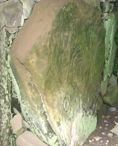
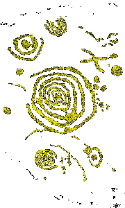
The passage, 4m in length and 1m wide, was subdivided by sill-stones into
three compartments each containing cremated remains. The engraved stone
inside the mound of Hostages has been likened to a map of Tara hill itself.
There is a similarity between the
layout of the bank and ditch constructions and rock-art from the same
period.
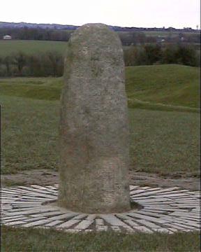
The Stone of destiny -
Originally stood on top of the Mound of
Hostages.
The
Hill of Tara in the Royal County of Meath was for centuries in ancient times
the seat of the High King of Ireland, the Ard Ri. This monolith is called
the Lia Fial, The Stone of Fal or the Stone of Destiny. The tradition is
that the High Kings of Ireland would be crowned here, and that the Stone
would roar or cry out loudly if touched by the true High King. Some believe
that the original Stone of Fal was taken to England and placed under the
Coronation Throne in Westminster Abbey, then in the current Century stolen,
taken into safe keeping in Scotland. Who now knows which is the true Lia
Fial or where it lies!
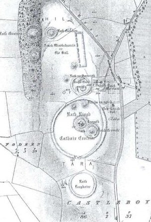
On the Hill of Tara there are the remains of
many other earthworks. To the South of the Mound of the Hostages, inside the
bank and the ditch of the so-called Royal Enclosure, stand two linked
ring-forts known as the
Royal Seat and the Forradh. The Forradh has two banks and two
ditches around it. In its centre lies the Lia F�il, the Stone of
Destiny, the most obvious phallic symbol of ancient Ireland. It once stood
near the Mound of the Hostages, and it is said to be the stone of the
coronation of the kings of Ireland. It roared three times when the future
king stood on it. Other legends say it was the pillow of Jacob or the
coronation Stone of Scone of Westminster Abbey.
To the south of the Royal Enclosure are the
remains of another circular earthwork known as the Fort of King Laoghaire,
where the king is said to be buried fully armed and in an upright position
in order to see his enemies coming. To the north of the Royal Enclosure
there are other round earthworks, two of them known as Sloping Trenches
and one
Gr�inne's Fort, named for King Cormac's daughter who was the heroine of
the tragic love tale of Diarmuid and Gr�inne.
Rath
Maeve Henge
-
Half a mile to the South of Tara Hill there is
a henge called Rath Maeve (after the legendary goddess-queen Maeve or Medbh).
It is about 230m (750ft) in diameter, part of its bank and ditch is well
preserved near the road.
Chronology -
Archaeology has established that human activity on the hilltop goes back
to the Neolithic period, about five and a half thousand years age, although
the earliest historical references to Tara only date from the seventh
century AD.
(1)
Archaeo-astronomy
-
Aligned to the Mound of hostages is the
so-called Banqueting Hall. This rectangular earthwork of 230x27m (755x89ft),
Neolithic in date is in fact probably a cursus, of which there are now known
to be others in Ireland (One on the
Boyne Valley,
and another at
Loughcrew).
It is orientated N-S
The Desecration of the Tara Valley:
The Gabhra (Tara-Skreen) Valley is
currently in the process of being desecrated by the construction
of the M3 motorway, which passes straight through the heart of
one of Irelands most sacred prehistoric landscapes; Destroying
over 100 prehistoric sites on the process.
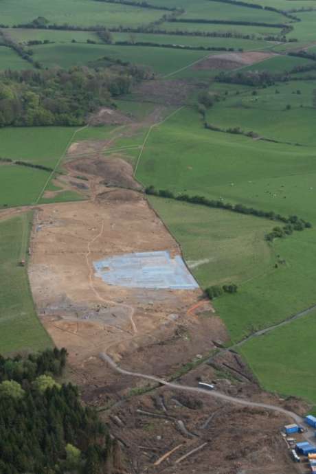
The Lismullen
henge (Partially shaded in blue area in the photo above).
It is only
recently that archaeologists are beginning to view individual
sites in terms of their place in the overall prehistoric
landscape.
�The
monuments around Tara cannot be viewed in isolation, or as
individual sites, but must be seen in the context of an intact
archaeological landscape, which should not under any circumstances
be disturbed, in terms of visual or direct impact on the monuments
themselves�
Ref: (N3 Navan to
Dunshaughlin Route Selection, August 2000, paragraph 7.3)
Scheduled to open in
2010, the M3's loudest critics concede much of the damage is already
done � 38 archaeological sites unearthed during construction thus far
have been carved from the landscape. Among the now vanished finds, a
newly discovered national monument at Lismullin that one leading
archaeologist described as "The wooden equivalent of Stonehenge."
"All these sites,
including the monument at Lismullin, were part and parcel of the greater
whole that is the Hill of Tara complex and now they are gone,
demolished. The damage is complete and irreversible," said Vincent
Salafia of Tara Watch. "Some would say, `Give up the fight. The deed is
done.' But we're not giving up because what we are most against is the
building of the motorway through the valley that is at the heart of the
Tara complex. It's a long ways from completion and there is still time
to come to our senses.
Opponents of the
M3 have called on the European Parliament and the European
Commission to intervene by asking the Irish government to review
its plans and conduct an independent investigation into the
highway�s impact on the Tara landscape. Campaigners first
approached the commission for help in June 2005. The commission
subsequently determined that the road construction violated EU
law governing environmental impact assessments; however, it has
yet to actually submit a case before the European Court of
Justice, and that delay has allowed the Irish government and the
Roads Authority to continue construction. On April 2, 2008,
campaigners came before the EU Parliament�s petitions committee
to resolve the problem. An EU Commission spokesman said the
commission would be submitting an application to the court in
the coming months; however, he said the commission did not have
the authority to halt construction in the interim, as road
opponents had hoped.
Those who are expert in this area and in the area of Tara are of
no doubt that this ritual site, really a temple, is part of the
extended Tara complex. It is about 500metres from the area of
Rath Lugh also flagged as being under threat of the motorway.
This is the place about which there was such a furore in
January. The NRA is trying to fit the road between these
monuments � this was shown in photographs in the past.
This point in the Gabhra Valley is the entrance to Tara. It was
more or less expected that a henge would be found in this
location. They are usually associated with Passage Tombs. Conor
Newman and Joe Fenwick recorded the existence of a straight line
of Passage Tombs running from the river Boyne southwards right
through the Gabhra Valley and up to the top of the hill. The
Mound of the Hostages is surrounded by a henge also, this is
200metres in diameter and is much larger than the Lismullin
Henge that is 80metres, still a very large area. These two
henges are about the same distance apart as Knowth and Dowth are
from each other. No one would doubt that the latter two are
related to each other.
It is no accident that
this henge is exactly where it is.
Learn more about the issue and keep abreast
of new developments by visiting the websites for the
Save Tara
campaign and
TaraWatch.
You can sign an
online petition addressed to Irish Prime Minister Bertie
Ahern, and join the network of Tara activists through
MySpace and
Facebook. You can also get involved with the New York-based
World Monument Fund, which is working to protect Tara and
other endangered sites.
