|
 Earth Navels: (Navel's of the earth,
Omphalos)
Earth Navels: (Navel's of the earth,
Omphalos)
The term 'Earth Navel' was applied
to several 'sacred' locations from the ancient world. Generally, these sites
were accredited with the title following their development into a 'sacred'
or 'special' place, such as Delphi or
Jerusalem, but in certain cases, the original name
of the site contained a translation of the word 'navel'. It appears then,
that certain sites were given this status during construction. The ancient
Peruvian capital Cuzco, for example, literally
means 'navel', and it acted as such to the Inca empire during its great
expansion. The mythology of Cuzco recalls that the city was located by the
'children of the sun', from Tiahuanaco,
according to pre-designed rituals.
The ancient landscape was a canvas
upon which in prehistory, our ancestors connected points on the ground
with points in the sky, There is much evidence that certain
ancient cities and constructions were located according to 'geodetic'
or 'geomantic' principles, and these ancient centres are now termed
'earth navel's' because of this.
The suggestion of a further geometric connection
or of alignments between sacred sites has always been a bone of contention for
mainstream pre-historians, who still argue that Neolithic people were
simple tribal, hunter/gatherers, with only basic skills, as yet
not identifying any presence of any order or hierarchy in their
society, which might facilitate the existence of such grand
architecture.
There are several locations around
the ancient world that have inherited the accolade of 'Earth
Navel'. By definition, each location represents the place through
which we connected with an invisible umbilical connection
to the earth-mother-earth. These sites are invariably considered
the centre of the world, or even the universe, and often become
primary pilgrimage locations (such as Mecca or Allahabad).
It has long been argued that there
may exist a geometric connection between such sites, with a clear
geodetic connection between Delphi and Karnak (Egypt), as
established by Livvio Stecchini.
Stecchini
said this about the subject:-
�The Temple of Ammon at Thebes at latitude 25� 43� N was
considered, and is, located at 2/7 of the distance between the
Equator and the pole. Ancient geographers divided the space
between the Equator and the Pole into 7 zones. Egyptologists have
vainly tried to explain why the Greeks gave the name of Thebai to
the city called Wast by the Egyptians; the explanation is provided
by the Hebrew word thibbun meaning �navel�. From the Bible (Jud.
9:37) we learn that �a navel of the earth� was located at Mt.
Gerizim where there was originally the sacred center of the
Hebrews before it was moved to Jerusalem; the Samaritans never
accepted such a shift, and geographically they were right, since
the claim of Jerusalem to be the navel of the earth was not
correct. The eastern gate of the
Second
Temple, where the standards of length were located,
was called Gate of
Susa, but
Susa was located at the latitude of
Mt.
Gerizim which is 32� 11� N. The sanctuary of
Mt.
Gerizim was located at a latitude that is 2� sevenths
from the Equator. Egyptian benchmarks had the shape of the �navel�
found at the
Temple of
Delphoi in
Greece. These �navels� had the shape of a hemisphere
with the meridians and parallels marked upon them; at times they
are half a sphere and at times they are elongated at the Pole. The
sanctuary of Delphoi was considered a �navel of the earth,� as
being located at 3/7 of the distance from the Equator to the Pole.
This would correspond to a latitude 38� 34� N; the Temple of
Delphoi is actually located at a latitude 38� 29� N, � which makes
it 6� to the North of one of two Egyptian anchor points, the
original apex of the Nile Delta at latitude 30� 05� N on the axis
of Egypt which is 31� 13� E. Susa was computed as being 17� to the
East of this point; it is at latitude 48� 15� E. When the
Assyrians established their religious capital at
Nimrud in 875 B.C. they chose a point that was 6� to
the North and 12� to the East of this Egyptian anchor point. (5)
(See below for list of Earth
Navel's)
|
Omphalos: (Navel stones):
|
Perhaps
surprisingly, the oldest known 'Omphalos' is on view in the Sofia
Museum, Bulgaria. It is from the Vinca culture which dates between 3,000
to 5,000 BC. Many Vinca buildings were found to have had an 'Omphalos'
area set aside in them. The Vinca culture dissipated from 'Old Europe'
c. 3,500 BC, vestiges of the same culture can be seen around the
Mediterranean basin and beyond
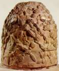
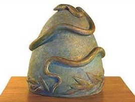
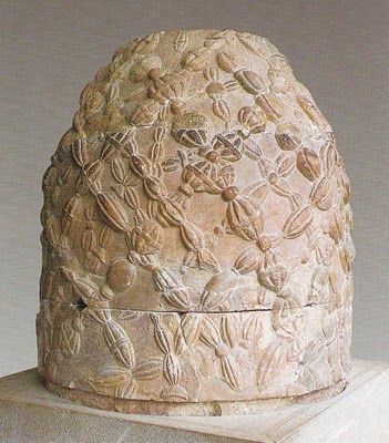
Vinca Omphalos stone. (Note the presence of netting and a bird figure on
top).
(More
about the Vinca Culture)
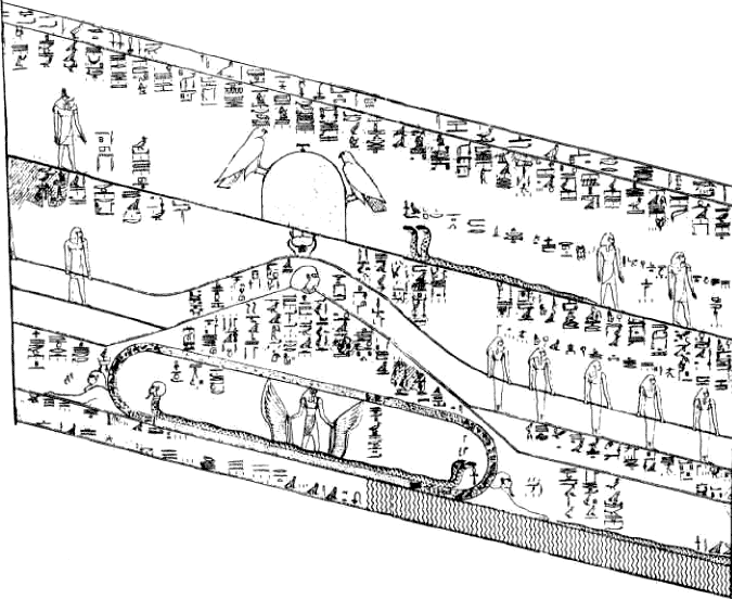
The
earliest Egyptian depiction of an Omphalos is seen on the walls of the
Seti I pyramid.
Omphalos stones
have been found at several sacred sites. (i.e. Delphi, Dodona and Thebes
(Egypt). Within these stones lies a symbolism which is almost lost to us
now. Although not at
first apparent, the Omphalos stones from Thebes and Delphi have several
features in common through which it is possible to see the fusion of
Egyptian and Greek iconography and mythology, and the thread of an older
set of ideas.
 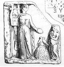
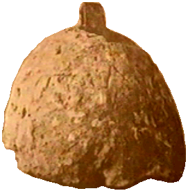
Thebes, Egypt
(left), Greek engraving of Delphi (Note: Apollo�s harp, Doves), (right).
Service and
Bradbury
(2), state that 'Within concept of the
Omphalos, there is also
implied an umbilical cord, an invisible link reaching from the depths of the
earth through the navel right up into the heavens' (Roscher 1913)
(2).
Pennick
(28), notes that the Roman author Varro compared the
Omphalos shape
with a �treasury�, the name commonly applied to dome-shaped graves (such as
the �Treasury of Atreus� at Mycenae, so described by Pausanias). The
suggestion that the Treasury of Atreus may be an Omphalos of �negative
space�, is of interest as we are told that the site was �Treasury� was built
on the site of the old oracle of the earth goddess herself, with legends
stating that Python, the serpent spirit of the earth, lays buried there
having been killed by Apollo the sun god.
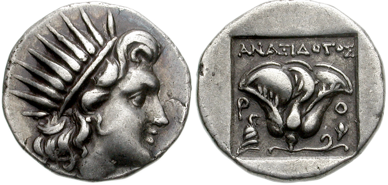 
Omphalos Stones on Greek 1st - 2nd Cent. BC
Coins.
Following on the work of Michell,
Stecchini, Temple and others, Hancock
(1), suggested that an ancient
network of geodetic centres was established, which were connected
mathematically.
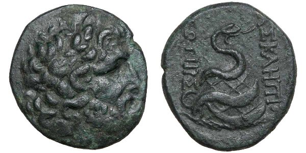
The Delos Omphalos, Greece.
(More about Delos)
Livvio
Stecchini suggested that the ancient
oracle centres
were placed according to geodetic principles at which 'Omphalus' or 'Navel
stones' were placed. This idea is supported by the historical narratives of
Herodotus, who wrote that the oracle centre of Amon in Libya was founded by
flying doves from Thebes, which was long considered the geodetic centre of
ancient Egypt, is located 2/7ths of the distance from the equator and the
North pole, and at which an Omphalus was later discovered. Herodotus also
wrote that the oracle centre at
Dodona was
said to have been founded by Egyptian priestesses from Thebes and that doves
flew between the two sites.
Following this, Robert Temple suggested that the
separation of the oracle centres, each by 1 �
of latitude created an 'oracle octave', from which the seven major centres
were placed, each devoted to one of the seven know planets, and symbolised
by different sacred trees and letters (for more on this subject refer to the
'tree alphabet' in R. Graves book 'The White Goddess'), and this, he
believed formed the basis of the
Eleusian mysteries.
(More about the
Oracle centres)
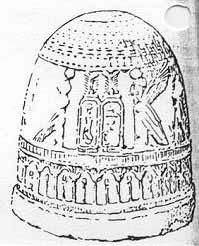
The Delphi
Omphalos before restoration (left), and after (right).
There are two myths
concerning the origin of the Delphi oracle. The first says that Zeus
wishing to find the centre of the earth sent two eagles to the ends
of the earth and they met at Delphi thus making it the centre or
�navel� of the earth. (Many Omphalos have two birds on to symbolise
this). The second myth says that it was dedicated originally to the
mother of the gods, Gaia. The oracles were said to have been
protected by Python (Gaia's daughter). Apollo slew Python making
himself master of the oracle and burying her under the Omphalos
stone. As a punishment because he had killed a god, Apollo had to
leave Delphi every three months during the winter. Many scholars
believe that the Python�s death at the hand of Apollo symbolized the
change in oracles at Delphi.
(More
about Delphi)
|
Omphalos: 'Plugging the Deep'.
|
Santillana
(4), offers several examples to support the
association between navel-stones and �the flood� by referring to their function
as �plugs�; an idea typified by the following phrase �The opening of the
navel brings the deluge�. However of even greater interest is that we see in
�Hamlet�s Mill�, that certain common subject matter has been approached but
through a different medium, namely mythology. The primary emphasis of their
research was the existence of an ancient system of astronomical/ astrological
knowledge involving the precession of the equinoxes, and the constellations,
stored in mythologies around the world. It is from their work we are made aware
of a significant set of stories concerning the purpose of navel-stones, through
which such already described associations are reinforced.
In the Sumerian myth of Utnapishtim (Noah), we are told
that the first ark was �a cube measuring 60x60x60 fathoms�,
which represents the unit in sexagesimal system (where 60 is written as 1 or 1�
). In one version, we are told that �there is no ark, just a cubic stone,
which rests on a pillar which reaches from earth to heaven�. In the Old
Testament, these elements are repeated, when we learn that Noah�s ark was also a
cube, whose landing symbolised the end of the great flood. In Jewish legends, it
is said that �since the ark disappeared there was a stone in its place�which
was called the foundation stone��and it is said to lie above the waters that
are below the Holy of Holies. In
Mecca, the navel
of the Islam faith, there stands the Holy stone of the Ka�aba, which is also a
cube, and we are told that even Christ is compared to �a cube shaped mountain�.
But why a cube?
Apart from the obvious fact that a cube represents a single
unit (as in the Sumerian base-6), the traditional reason for the cube-shape is
suggested as being the shape designated for the planet Saturn, as illustrated in
Keplers �Mysterium Cosmographicum�. To support this idea Santillana
reminds us that in this group of stories, the figure (power) who warns �Noah� of
the impending flood, (and suggests the dimensions of the
Ark), is ��Saturn,
as Jehovah, as Enki, as Tane, etc��. The antiquity of these traditions is
shown by the fact that In pre-Islamic days, before the Ka�aba was constructed,
there was a well on the site, which had a statue of the �God�� Hubal, across the
opening �to prevent the waters from rising�. Hildegard Levy points out
that, in pre-Islamic days, the god Hubal was Saturn, and that the Holy stone of
the Ka�aba served the same symbolic function
(4).
In addition to having
been recorded as the first Greek oracle centre, Dodona has a still greater,
and older claim to fame being located at the foot of Mount Tomaros, which is
named in Greek myth as the refuge for Deucalion and his wife, the sole
survivors of the great �flood of Deucalion�. It is within this myth that an
older, perhaps hidden significance (and connection), can be found in the
location of Dodona, for while Mt. Tomaros is the reputed resting place of the
Greek ark, the Hebrews record the final resting place of their ark as being on
Mount Ararat in Turkey (near Metsamor), which
both sits on the same latitude as Dodona and happens to be equidistant from
Thebes, so that the three locations form an almost perfect equilateral
triangle.
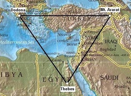
While it is possible that such a geometric connection between sites may be a
coincidence, the earlier mythological connection through the flood-myth is
harder to explain. It is not possible to know if the significance of the site
was already known to the Egyptian priests at Thebes
(or Phoenicians) when the oracle at Dodona was
established, but there is little doubt that the location had a special
significance from before the arrival of the Egyptian oracles.
(More
about Egyptian Geodesy)
There has
been much speculation over the existence of a 'world-grid' - But
what exactly is it?
The two general theories
about a 'world grid' are:
-
The most common
theory suggests the presence of tangible earth-energies which
flow in lines around the world and which can be either
reinforced or tapped into through the building of megalithic and
sacred structures along their path. It is speculated that at
some time in the past, our ancestors constructed sacred sites at
certain locations at nodes of these energy lines.
-
The other theory
also involves the construction of ancient and sacred sites, only
it speculates that their placement was based on geometric
principles. This theory is often associated with the mysterious knowledge of 'sacred geometry', and is not
exclusively involved with energy, although there is
suggestion of magnification of universal energies through
constructions designed with certain proportions.
For the purpose
of this page, we are concerned only with the latter theory,
which suggests the placement of ancient and sacred sites
according to geometric principles. The late, great,
Alexander Thom determined the presence of geometry at
numerous megalithic locations and concluded that the builders had applied 'Euclidean'
geometry in the construction of many significant sites.
(More
about the World-Grid)
|
Examples of Earth Navels:
|
Cuzco - Literally translated means 'Navel'. The capital of the Inca
empire was situated at Cuzco, high in the Andes. Tradition states that the
city was founded according to 'geomantic' principles.
Easter Island -
Was also called 'Te-Pito-O-Te Henua' Which translated means, 'The
Navel of the Earth'. Hancock suggested that its geographical location may
have determined the original settlement.
(1)
Jerusalem - As
the capital of the 'Holy land' Jerusalem is called an Earth Navel.
Delphi -
Contained an 'Omphalus', which
was believed to mark the centre of the world. It was supposed to have fallen
from heaven. The story is that Cronus, the god of time, was driven to the
depths of the universe by Zeus, who forced him to vomit the stone, which
landed in the centre of the Earth. The current Omphalus is a replica of the
original, made in the Hellenistic period.
(1)
Eridu
- Iraq. The
original Sumerian 'Mound of Creation'.
Angkor Wat - The 'Bayon'
in the network of temples at Angkor was described by B. Groslier as 'the
Omphalus in Angkor's stone cosmos'.
(1)
Karnak, Egypt - An
Omphalus was excavated in the sanctuary of the Great Temple of Amon at
Karnak, by G. A. Reisner. It supports the Greek traditions of doves flying
between Delphi and Karnak. (1)
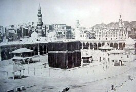
Mecca - The centre of Islam. The
location of the
Kabba,
and the 'black stone' which, according to Islamic tradition, fell
from heaven during the time of Adam and Eve. It is said that Abraham found
the black rock and when he rebuilt the Kaaba, Archangel Gabriel brought the
Stone out of hiding and gave it to him.
Ref(
http://en.wikipedia.org/wiki/Kaaba )
Allahabad, India - Formerly called Prayag, and
listed in the Mahabharata as the last and most important of 270
ancient holy places. Prayag was considered the mythical creation point of
the universe. The chief cult shrines at Prayag stood on an island with a
shrine to the primordial serpent who protected the eternal tree (seen by
Hsuan Tsang in 644). A goddess-shrine was recently found south of
Allahabad that dates to 11,000 BC, along with Mesolithic cave paintings of a
dancing shaman with horned head-dress, bangles and a trident, closely
resembling Shiva.
(3)
Allahabad is still the site of
the largest gathering of humanity on earth.
(The Oracle
Centres)
(Earth-mother-earth)
(Geodesy
Homepage)
|