|
Location:
Chaco canyon,
Albuquerque,
New Mexico. |
Grid Reference:
36� 3' 37"
N, 107� 57' 42"
W |
 Chaco Canyon:
(The 'Sun Dagger').
Chaco Canyon:
(The 'Sun Dagger').
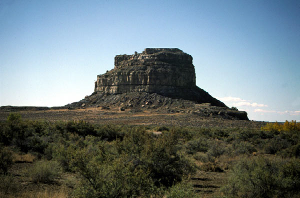
 Rising nearly 400 feet above the desert floor in a remote section of
ancient Anasazi territory named Chaco Canyon stands an imposing natural
structure called Fajada Butte. Along a narrow ledge near the top of the
butte is a sacred Native American site given the name Sun Dagger
that a thousand years ago revealed the changing seasons to the Anasazi
astronomers. Rising nearly 400 feet above the desert floor in a remote section of
ancient Anasazi territory named Chaco Canyon stands an imposing natural
structure called Fajada Butte. Along a narrow ledge near the top of the
butte is a sacred Native American site given the name Sun Dagger
that a thousand years ago revealed the changing seasons to the Anasazi
astronomers.
After they abandoned the canyon for unknown
reasons 700 years ago the sun dagger's secret remained hidden except to
a special few. In 1977 it was inadvertently "rediscovered" when known or
suspected rock art and petroglyphs on the butte were being studied and
catalogued.
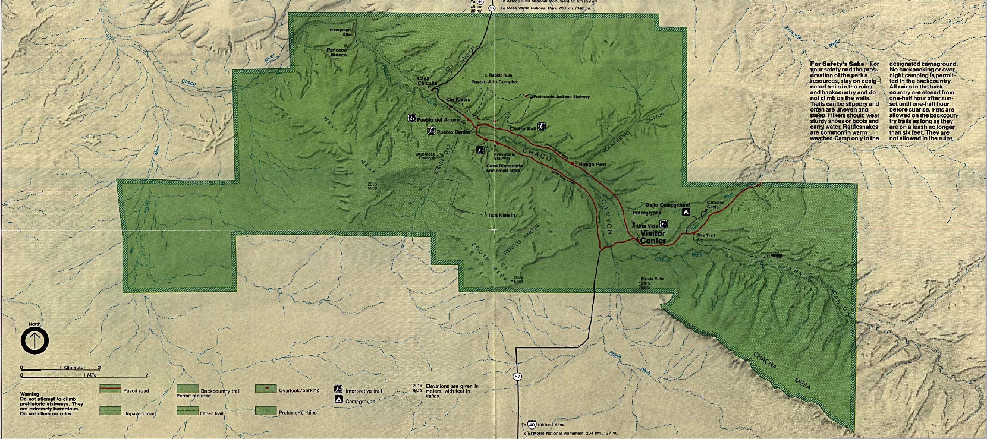
(Click here for map of the site)
|
The Chaco Canyon Sun Dagger: |
In 1977 Anna Sofaer, an
artist, was exploring rock art in the region and came across the light
patterns on the two spirals. Suspecting that the rock arrangement and
spiral carvings might have been intentional, she returned to the site at
various dates throughout the year and, along with her colleagues, was
eventually able to establish the following facts:
In what is now the state of New Mexico
in the south-western United States, in an area known as Chaco Canyon, are
the remains of an elaborate development of the Anasazi people who lived
in the region from about 500 to 1300 AD. Some 120 meters (400 feet)
above the canyon floor near the top of an outcropping known as Fajada
Butte, three slabs of sandstone are leaning against a rock wall creating
a shaded space. Carved into this shaded wall are two spiral petroglyphs,
one large and one small. Sunlight passes over them at various times
throughout the year as it streams through chinks between the sandstone,
but it was not until the 1970s that their true purpose was literally
illumined.
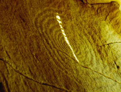
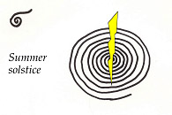
On the summer
solstice, a single sliver of sunlight�which she dubbed a "Sun
dagger"�appeared near the top of the larger spiral and over a period of
18 minutes "sliced" its way down through the very center, cutting the
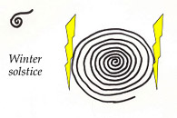
spiral in half before leaving it in shadow once again. On the winter
solstice, two daggers of light appeared for 49 minutes, during which
they exactly framed the large spiral.
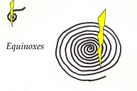
Finally, an equally fascinating and
more complex light show occurred on the spring and autumn
equinoxes. The large spiral is
carved in such a way that, counting from the center outward to the
right, there are nine grooves. On each equinox a dagger of light
appeared that cut through the large spiral�not through its center but
exactly between the fourth and fifth grooves from the centre. In other
words, it cut exactly halfway between the centre and the outer edge of
the spiral, just as the equinoxes cut the time between the solstices
exactly in half. Meanwhile, a second dagger sliced through the centre of
the small spiral.
These "light shows," which presumably
had been going on for centuries, continued for several years after their
rediscovery. However, in 1989 it was found that the granite slabs had
shifted. The alignments that had apparently been arranged so carefully
by the Anasazi were no more.
Similar light displays marking the
solstices and/or equinoxes can be found at other locations in the
southwestern United States and Mexico. In another Anasazi ruin in
Hovenweep National Monument near the borders of Utah and Colorado, light
beams also illuminate spiral petroglyphs on the summer solstice. At
Burro Flats in Southern California, a winter solstice Sun points a
finger of light to the center of five concentric rings in an early
Chumash rock art display. In a Tipai shrine known as La Rumorosa in Baja
California on the western coast of Mexico, a dramatic display can be
witnessed on the winter solstice when a "dagger" of light appears to
shine from the eyes of a figure painted on a shaded rock wall.
(1), (2)
|
The Moon-dagger.
Moonlight
generally creates the same patterns on the spirals as the sun, on
nights when the moon is between first and third quarter. The
periodic changes in these patterns reflect the complexity of the
moon's apparent motion, and certain combinations of patterns are
associated with specific lunar eclipses.
Lunar observations.
The patterns formed at
night by moonlight shining between the slabs are just as clear and
as noticeable as those formed by the sun, and we easily recorded
them on several nights near full moons (Fig. 10). It is not
necessary to make a detailed record of these patterns for most
positions of the moon, since at a particular point in the sky it
will form the same light patterns on the spirals as the sun would
at the same point. When the moon's declination is between + 23.5�
and - 23. 5� (the solar extremes) we can thus predict the patterns
formed by its light by knowing those formed by the sun at the same
declination. But the moon's declination can vary outside the solar
limits, up to +/- 28.5� over part of an 18.6-year cycle, and
whenever it lies beyond the extremes of the sun's declination we
have no corresponding solar data. Since this periodic extreme in
the moon's declination will not be reached again until 1987, we
cannot yet make direct observations of the patterns formed by the
moon at such declinations. As discussed later in this article,
extrapolations from the solar data suggest that a significant
marking of the maximum lunar declination may occur.
(3)
|
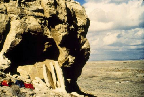
The Stone Slabs
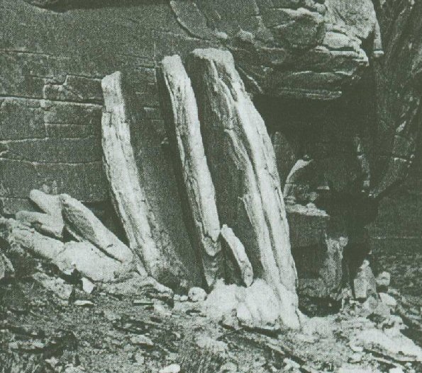
The three slabs stand on the sloping
ledge at the foot of the cliff, each contacting the cliff over only a
small area . On the left of slab three is a supporting buttress of
smaller rocks and under the right edge of slab one is a small supporting
rock. All the slabs and rocks of the assembly consist of the same soft
sandstone as the cliff itself. The slabs are roughly rectangular (2 to 3
m high, 0.7 to 1 m wide, and 20 to 50 cm thick) and weigh about 2000
kilograms each. The outer surfaces and tops are rounded and weathered,
the inner surfaces smooth and gently curved with sharp edges. By
comparing the matching details on the facing surfaces of the slabs, it
has been determined that these slabs once fitted together to form one
block. The place where this block was joined to the cliff face was found
by noting the strata and bedding planes and the curvature of the cliff
face). By such comparison, the original location of each slab was
found to within 1 cm, well to the left of the present locations.
Several pieces of evidence
rule against the slabs' having fallen into their present positions
naturally. First, the slabs would have had to move 2 m and more horizontally
while the centre of gravity of the three together fell only about 80 cm
vertically. In particular, the centre of slab three by itself is now only 30
cm lower than when it was attached to the cliff. Second, there are no impact
marks, either on the cliff face or on the inner edges of the slabs, to
suggest a collision. Third, the cliff face above the original location of
the slabs shows that another rock mass had broken away from there. This
higher rock could not have broken off before the slabs did. Had it broken
off with (or after) the slabs, it would have prevented them from falling
naturally to their present location. There is no evidence today of this rock
mass. Indeed the absence of rubble near the slabs is unusual on the butte,
where fallen rock is found below other such cliffs. Fourth, the slabs are
set firmly in place on a rocky ledge and are partially supported by
buttressing stones. We conclude that moving and setting the slabs in their
present position involved deliberate human intervention.
|
Disaster struck in 1989 when erosion of the clay and
gravel around the base of the stone monoliths caused them to slip.
As
the slabs inched down the steep slope of the butte, the sun dagger
vanished. Having unobtrusively marked the passage of seasons for
centuries; it lasted only ten years after its discovery before it was
lost forever.
The loss of the sun dagger prompted the World
Monuments Fund to add Chaco Canyon--now known as Chaco Culture National
Historical Park--to its Most Endangered Monuments list in 1996.
A digital model of the original structure has now been
developed and efforts are underway to restore the monument.
|
The Anasazi - A Cultural Background
Indications that the Fajada Butte solar
marking construct was developed within the period A.D. 950 to 1150 are
the planning skills and solar interests exhibited by the Chaco occupants
at that time.
(3)
The canyon contains the ruins of the largest
pre-Columbian "city" in what is now the United States.
Several factors show that the Anasazi
inhabitants of Chaco developed the construct between A.D. 900 and 1300
(the approximate date of Pueblo abandonment of the canyon) and indicate
that the specific time was between A.D. 950 and 1150, the period of
greatest population and development in the canyon.
Certain rock art sites of the ancient
Pueblos are reported to mark solar positions by the placement of designs
to receive shadow and light formation at the rising and setting of the
sun at solstice or equinox, and one such site includes a spiral design.
Two petroglyph sites on Fajada Butte are marked with shadow and light
changes at the time of solar noon at summer solstice, and one of these
includes a spiral design. The spiral is frequently found in association
with ancient Pueblo petroglyphs of sun imagery. It is identified with
the Anasazi rock art style prior to A.D. 1300. Examples of architecture
of the same period have openings that channel light so that it shines on
key features of the structures such as doorways, niches, and corners at
the solstices and equinoxes
(3)
The site's nine "great houses," the largest of
which stood five stories high and had 650 dwelling rooms and 37
ceremonial kivas, along with some 3,500 smaller structures in and
around the canyon, may have housed up to 10,000 people at a time.
Chaco was the hub of a network of roads-at least 20 of them, each
nearly 30 feet wide-that radiated in all directions for distances of
up to 100 miles, suggesting that the site may have been a part-time
home to pilgrims from other Anasazi settlements who came here for
religious ceremonies, trade, or both.
A new study of the Southwestern landscape has
revealed that three of the region's largest and most important ancient
centers were linked by a 450-mile meridian line - Chaco Canyon, in New
Mexico; Aztec Ruins, 55 miles due north near the Colorado state line;
and Casas Grandes, 390 miles due south in Chihuahua, Mexico. Chaco and
Aztec were also connected along the meridian by a road known today as
the Great North Road (see ARCHAEOLOGY, January/February 1994).
(Other Mexican Sites)
(More about Archaeo-astronomy)
|