|
Location: Various
locations on Malta and Gozo. |
Grid Reference:
Several. |
 Maltese Cart-ruts:
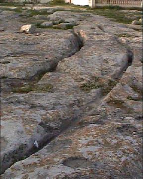
The island of Malta is
scored by numerous examples of ancient cart ruts, they have been the
subject of debate for hundreds of years, and their origin, form and
function continues to arouse interest to this day.
There are several distinct 'sets' of cart-ruts on both Malta and
neighbouring Gozo. Cart-ruts have been found underwater around the islands
too.
Certain physical features of the ruts, combined with a lack
of informative evidence concerning their function has led to a variety of
speculative theories.
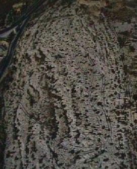
(Map with location of cart-ruts on Malta)
|
Maltese Cart Ruts: An overview. |
Although Malta is home to the highest concentration of cart-ruts in
the world, their origin and function is still greatly unknown.
How were they made
- It is generally assumed that the pairs of 'ruts' were made by some
form of vehicle (possibly wheeled). Furthermore, it is assumed that they
were produced by repeatedly carrying heavy loads, such as
stones to the temples. However, there are several objections to this idea. For example:
A single, wide rut has been found
underwater (2).
There are no cart-ruts running
directly to any of the temples, and there are locations where ruts run
past temples. Evidence of association between the two is ambiguous.
Some ruts run for Kilometres,
(i.e. 3km at San Pawl tat-Targa, Naxxar), and one does not need to
travel that far to find stone on Malta.
(1)
Other
ruts run uphill and down.
One remarkable example climbs an angle of as much as
45�,
making a difficult manoeuvre, whatever the load.
(1)
 Other minor contentions to the
'temple-stone' theory include the fact that the ruts meander almost
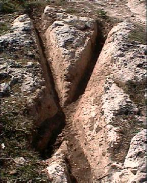
unnecessarily (see Naxxar below); Others appear to start as suddenly as
they stop (see Clapham Junction photo right), and many of the ruts have
junctions that make little sense in terms of efficiency as a transport
system.
Note - Hancock
(1),
says 'It is certain, too, that they were not simply worn away in the
tough limestone by the passage of cart-wheels over periods of centuries,
as many have wrongly theorized; on the contrary, there is no proof
whatsoever that cart-wheels ever ran in these ruts -
which were initially carved out of the
bedrock with the use of tools'. (Hancock
references T. Heyerdahl for this statement).
Other minor contentions to the
'temple-stone' theory include the fact that the ruts meander almost
unnecessarily (see Naxxar below); Others appear to start as suddenly as
they stop (see Clapham Junction photo right), and many of the ruts have
junctions that make little sense in terms of efficiency as a transport
system.
Note - Hancock
(1),
says 'It is certain, too, that they were not simply worn away in the
tough limestone by the passage of cart-wheels over periods of centuries,
as many have wrongly theorized; on the contrary, there is no proof
whatsoever that cart-wheels ever ran in these ruts -
which were initially carved out of the
bedrock with the use of tools'. (Hancock
references T. Heyerdahl for this statement).
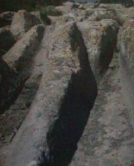
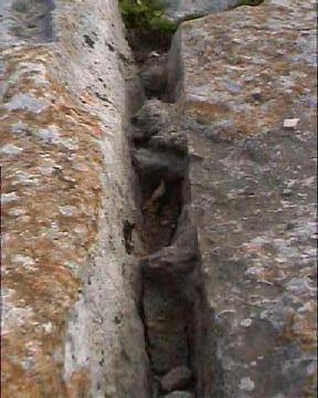
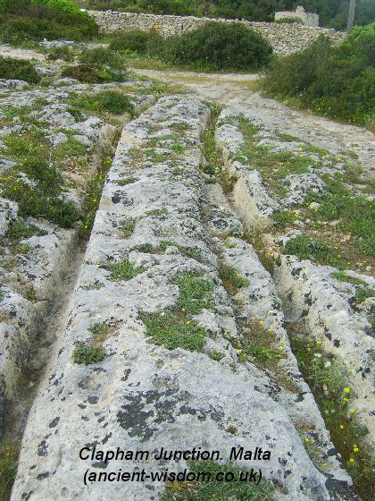
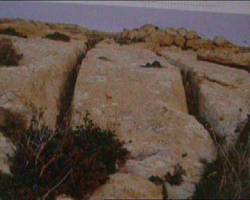
The photo right is from 'Clapham Junction'...
(It shows both vertical striations on the
sides and ends in solid rock).
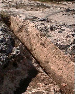
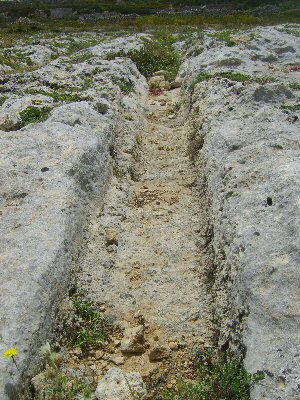
Gauge of the ruts:
The 'ruts' always run in pairs cut/worn into
rock with a 'standard' gauge of around 1.4m (From centre to centre),
although this too has been shown to vary by several centimetres
(2),
"They always occur in pairs from 52 to 58 inches apart"
(3).
Depth of the ruts: 'In some places
they have been found to run as deep as 60cm'
(1),
'The depths of the ruts range from a mere smoothing of the surface to more
than two feet. The greatest depth was 27 inches and there were several
measurements between 22 and 24 inches. These are the mean depths of a pair
of ruts taken from the highest point of the intervening rock. A wheel to
negotiate such ruts would need to be 5 feet in diameter, allowing only six
inches for the hub'
(3).
Chronology -
That they are ancient, is shown by the fact
that some have been found that run underwater. As our knowledge of changes
in sea-level over the past few thousand years increases, so does the
possibility of dating them more accurately. However, for the moment we have
to rely on visual evidence such as the pair at Ras il-Pellegrin that
runs under the site of a Roman villa. In several places, ruts are cut by
Punic tomb shafts, which can be dated roughly to the latter centuries BC.
(1)
Maltese researchers have more recently dated their �roads� to circa 4,000 �
5,000 BC.
(5)
Why were they made -
There is
no question that the original purpose of the ruts was for
transportation, and several sets are clearly associated with quarries on the
island however, as yet no evidence of vehicles (or the wheel) has been found
on the island.
-
The few
known cases where ruts were used to channel rain run-off to cisterns have
been shown to be secondary function (1)
-
The Maltese cart-ruts always appear in open places.
For more on the subject of how and why they cart ruts were made, click here:
(Cart-ruts
Homepage)
|
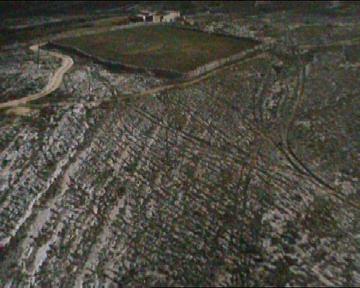
Examples of Maltese Cart-ruts: |
There are several concentrations of
cart-ruts on Malta. Each with something different to say for itself.
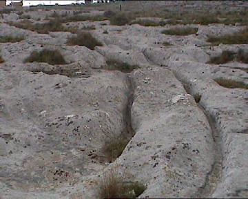
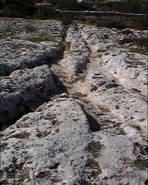
The Naxxar group - This group of cart-ruts is on the side of the
road and is not clearly marked on the maps. They meander down a gentle slope
 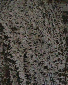
These
overheads of the Naxxar group illustrate the way in which tracks meander,
and a closer look reveals an interesting feature.
On the photo (right), which is an enlargement of the photo
(left), it is possible to see what appears to be a deliberate junction point between the
two sets of ruts. This apparent connection between ruts suggests a 'design'
or 'function'.
Note: although the cart-ruts in the photo 'appear' to
cater for two way 'traffic', this feature is an isolated example.
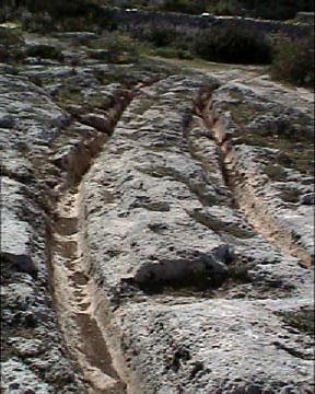
Other photo's of the Naxxar group
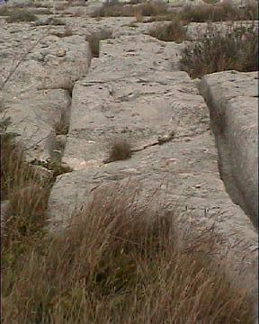
The ruts at Naxxar make a
sweeping turn almost back onto themselves.
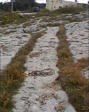
San
Gwann: (Tal Mensija):
One of the best sites on Malta.
This concentration of ruts
is located in the middle of an urban area. The site is small but contains some
interesting features and is well worth a visit.
The ruts at San Gwann are amongst the deepest
to be found on the island, reaching up to 0.5m in depth.
The uneven surface created by
the apparent 'crossing' from one rut to another (right) presents a
navigational nightmare for anyone attempting to 'use' them. In certain cases
it is difficult to imagine why such manoeuvres could/would have been
repeated (reinforcing the idea that the ruts were made with a single pass
instead of repeated passes).
Interesting features of the San Gwann cart-ruts.
The San Gwann cart-ruts are some of the best
on the Island. The area was once home to many more until developers built a
town over them. These are the last to be seen in the area today.
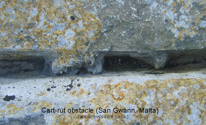
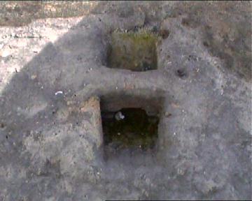
This peculiar feature is inside one of the cart-ruts at San Gwann.
(Note the crisp upper edge of the cart-rut, which runs evenly before and
after this obstruction).
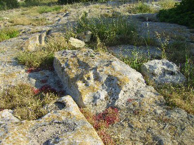
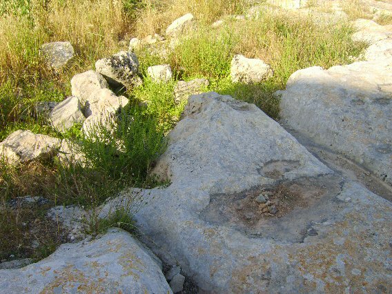
There is clear evidence of quarrying at San Gwann between the ruts.
Although the quarrying is undoubtedly a secondary feature, it has been noted
that the height and width of the quarried stone is the same as that of the
nearby (3-4km) Hal Tarxien temple (Site plaque).
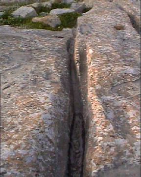
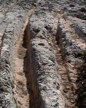
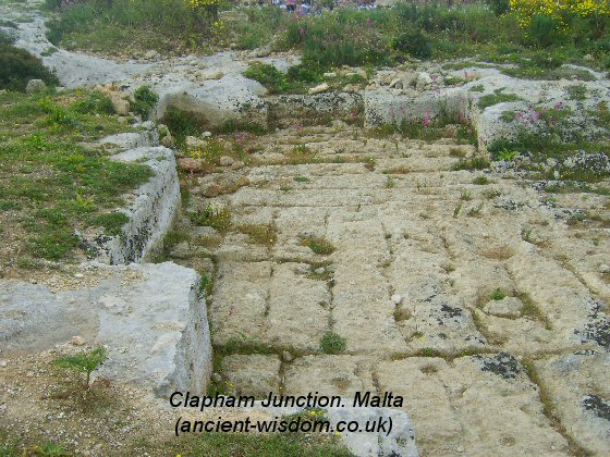
 'Clapham
Junction'
-
This aptly named site on the
southern side of the island has an enormous number of ruts, which fan out
and cross over each other.
This site offers the largest concentration of lines on the island. 'Clapham
Junction'
-
This aptly named site on the
southern side of the island has an enormous number of ruts, which fan out
and cross over each other.
This site offers the largest concentration of lines on the island.
Hancock says that at Clapham junction, he
found ruts 'Up to a metre deep, and in some cases almost a metre wide at the
surface-though narrowing at the base'
(2).
(Visits in
2004 and 2009 failed to confirm this report).
Ruts at this site have differing gauges, depths, widths,
and are shaped differently at the bottom, some narrowing and others
remaining flat. Such obvious differences at the same location raises
questions over the kind of vehicle that could have made such marks.
The close proximity of a quarry makes it a good candidate
for the function of these marks. although no direct evidence for such a
connection has been made (While these ruts are near the quarry, they do
not run to/from it).
It is argued that 'Where ruts do fork, the
two branches can frequently be shown to be successive rather than
contemporary, one pair being more deeply worn than the other'.
(1)
However, the following shots suggest otherwise...
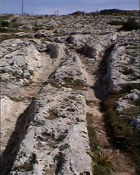
Many of the ruts appear to cross the junctions at the
same depths, which is just as well as any vehicles having to cross over the
30 or so different sets of fanning tracks, would have had a hard job.
At Clapham Junction, as at some
other sites, there is evidence of quarrying in proximity to the site...but how ancient
is it? Since both ruts and quarries occur where the rock is exposed, this
may have created a 'coincidental association. There are also known
cases where more recent quarrymen have taken advantage of ruts to make extraction
of stone easier (see San Gwann, Below).
(1)
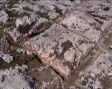
Clapham Junction Images.
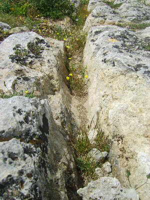
Some of the ruts are
V-shaped, while others are flat bottomed.
In this image, it appears as if a thin rut was over-run
by a wider one.
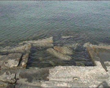
Underwater Cart-ruts:
Hancock
(2), writes of the existence of
cart-ruts 'on a gigantic scale underwater at Marfa Point'. He also quotes Sanzio
from 1776, who wrote that 'In several maritime sites around the island of
Malta, one could see deep cart ruts in the rock that extended for long
distances into the sea'. Following a dive, Hancock noted the differences
between these ruts and others found on Malta
(2).
1). They were
wider, 'It was possible to put my whole body down horizontally' he says.
2). Although
most ruts ran in pairs, there were 'several single channels even
wider and deeper than the others'.
3). 'At about
twice as wide at the base as the average ruts at Clapham Junction, these
proved everywhere I searched to be divided into two lanes by a
knife-edged rim of limestone about a hands breadth high that had been left
in place running the full length of the rut'.
4). Whereas
the 'top of the ruts at Clapham Junction lie flush with the bedrock...the
sides of the ruts rose about 30cm above the level of the
surrounding bedrock - like low, narrow, parallel walls'.
Hancock also
makes reference to 'Father Emmanuel Magri, the first official excavator of
the Hypogeum at Hal Safleni', who 'recorded the presence, up until the
end of the nineteenth century of cart-ruts on the tiny uninhabited island of
Filfla', a small island about 5 km south of Mnajdra and
Hagar Qim
temples. He then adds that in 1912, R. N. bradley commented on cart ruts
near Hagar Qim - noting that they ran "over the precipitous edge of the
cliff towards Filfla" (2).
The
conclusion of this information is that cart-ruts once ran all the way from
Hagar Qim to Filfla across a land bridge, which has collapsed since humans
first came to the island.
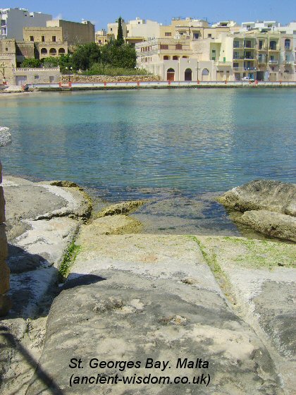
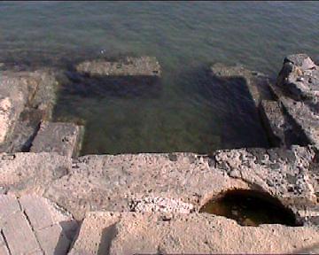
This set in St. Georges bay, runs
directly into
the sea...
Murray (3), made note of the St. Georges
bay cart-ruts. He said of them:
"At St. Georges Bay near Birzebuggia a cart-track
crosses a little spit of land which juts out into the bay. Before the houses
and marina were built, this track could be traced on each side of the bay.
It is evident that at one time the sea had not advanced so far as it has now
and that there was a road across the valley".
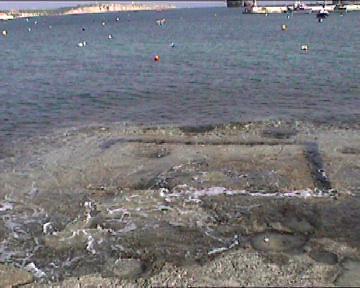
They are
surrounded by quarry marks.
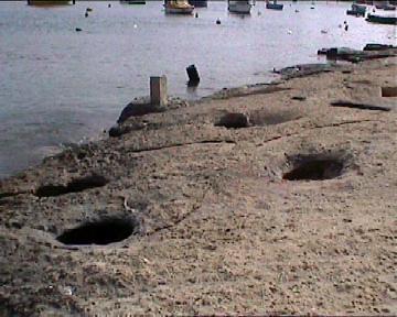
Numerous storage silos (with stone-carved
curved interiors) and a nearby 'hitching point'.
Cart-ruts in Other
Countries - Outside of Malta, similar 'worn
paired-grooves' have been seen in France, Spain, Greece, Switzerland, Sicily,
Sardinia, Italy,
Portugal,
Cyrenaica, Azerbaijan and S. America, usually associated with quarrying, and
of widely varied dates.
(1)
(Cart-ruts
Homepage)
|
Gallery of Images (Malta): |
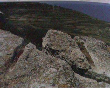
Up a step (left), and over a cliff (right).
(Cart-ruts Homepage) (More
about Mata) |
|