|
 Cursus:
(Form and Function)
Cursus:
(Form and Function)
A Cursus comprises of two parallel
linear ditches with internal banks, closed off at the ends. There are
around 200 examples known from all over the British Isles, as
follows:
England - Over 100
(6),
Scotland - 'Over 50' (4),
Ireland - 3, Wales - 9.
Still very little
is known about
these long, narrow earthwork structures date from the
Neolithic period, many from around 6,000 years ago - and thus
some of the oldest monumental structures in the British isles. They have been
found across Britain from southern England to Ireland and Scotland, and
stand beside some of the most famous archaeological sites in Britain,
such as at Stonehenge,
Thornborough and
Newgrange.
Definition: Concise
Oxford Dictionary of Archaeology.
Cursus (pl. cursūs ) [MC]. A
kind of Neolithic ceremonial monument comprising a rectangular
enclosure defined by a bank with external ditches. The longest
example is the pair of end-to-end joined cursūs known as the
Dorset Cursus on Cranborne Chase, Dorset, which together run for
more than 10km across the grain of the landscape. More
typically, cursūs are between 500m and 3km long and up to 80m
...
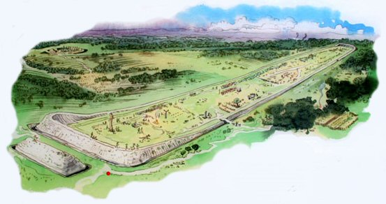
Artist's impression of Stonehenge Cursus.
Cursus monuments are essentially very long and relatively
narrow rectangular enclosures, with a near continuous boundary of an
interior bank and an exterior ditch. The only breaks in this boundary are
the 'causeways', or possible entrances. The ends of a cursus are either
squared-off or rounded. In Scotland, about half the known sites (which now
number over 50) have a boundary of pits or post-holes which held large
upright timbers, rather than earthwork perimeters. A few sites have a single
mound running along their centre, rather like a bank barrow.
|
What were the Function(s) of Cursus : |
The name 'cursus' derives from the
16th century antiquarian, William Stuckley's nineteenth century idea that they were 'prehistoric racetracks'.
This idea has long since evaporated and current thinking favours the idea
that
they may have served as processional or ritual gathering places.
It has been observed that cursus' often appear to
incorporate funerary monuments in their design, although these may have
been added later.
Manley (1), says 'It seems
likely that they were in some way utilised for astronomical purposes',
(1)
an idea which appears supported by the observation that the
Dorset, Stonehenge,
and Newgrange cursus'
appear to show significant alignments for astronomy
(2) (see below).
Manley (1) also suggests that the
Scottish 'double alignment of pits (often closed at one end)', could also
be related to Cursus'.
A 'British Archaeology' article by K. Brophy
(4), suggests that
there may be a connection between cursus monuments and streams and
rivers.
'The majority lie on flood-plains or river-terraces, close to the
river. The Dorset Cursus and the Eskdalemuir bank barrow in Dumfries and
Galloway are amongst several possible cursus which cross, or are crossed
by, rivers. Some sites are completely surrounded by waterways, like Maxey
Cursus in Cambridgeshire. Old Montrose Cursus in Angus sits on a raised
area of a valley floor which, in the event of flooding, could become an
island. Other sites may have had seasonally flooded ditches, creating a
powerful visual image when sunlight reflected off watery ditches
stretching across the landscape'.
He also noted that 'about half the known [Scottish] sites have a boundary
of pits post-holes which held large upright timbers, rather than earthwork
perimeters'
(4)
|
Cursus as Ungulate Traps.
A convincing argument is put forward by Robson
(8), for
the theory that cursus may have had their origin as large ungulate traps for
migrating pasture animals such as
deer or cow. The remains of hundred year old caribou traps can still be seen
today in Canada, which although not used since, still stretch across the landscape for miles. This idea
is clearly not in line with modern thinking as it suggests that the motivation
behind the labour was primarily survival, and that any ceremonial funerary (and
occasional astronomical) associations are ritualistic or secondary
additions.
 The theory in essence suggests that: The theory in essence suggests that:
Fences are built across the path of a known
migrating herd.
Animals are herded towards the cursus, then into its
environs, where they become effectively stuck.
The animals are later selectively removed from the cursus,
leaving little or no remains.
This theory also takes into account several
features of cursus, such as:
The presence of causewayed entrances, banks and
ditches.
It explains the presence of a river at many sites.
It explains the lack of astronomical continuity at
cursus.
The presence of wooden stakes at the ends of Scottish
cursus.
(Click here for more on this
subject) |
|
When were Cursus First Constructed? |
There are several curses
dated at before 3,000 BC (Dorset, Thornborough,
Boyne-valley,
Stonehenge). A
fact which shows how the location of certain important Neolithic sites have
been retained and re-used over time. The Scorton cursus, is dated at around
3,500 BC, with the oldest cursus appearing in Britain at around 4,000 BC
(4).
The Stonehenge Cursus has recently been dated at 3,500 BC
by a team from Manchester University.
(7)
There are two cursus at
Stonehenge, the nearest, which is also the largest, is orientated directly
towards the 'Woodhenge' monument.
The fact that both the Dorchester-on Thames Henge
in Oxfordshire, and the Thornborough cursus can be shown to have been built
over by henges, illustrates the antiquity of these mysterious structures.
The Rudstone landscape also show the presence
of a cursus. In
light of this finding, it seems a reasonable to propose that the cursus and the
henge are in some way related, as they both share the same intrinsic design
features: Being areas of flattened land surrounded by banks and ditches -
creating an artificial horizon line. The Henge being a latter, refined version
of the previous linear cursus form.
(More about Henges)
|
List and Description of UK Cursus: |
English Cursus.
(There are over a hundred Cursus in England alone)
(6)

Dorset Cursus
- The longest known Cursus in UK runs for nearly 10 Km and was laid out
sometime around 3,000 BC. The Dorset Cursus is actually two Cursus joined
end to end with an elbow in the middle
(1), with the southerly Gussage Cursus pre-dating the northerly
Pentridge Cursus (Wilipedia.org). Service and Bradbury
(2) say of the
Dorset cursus that it... 'aligns at various points with horizon markers
that indicate the rising or setting places of some important phases of the
moon'.
(More about the Dorset cursus)
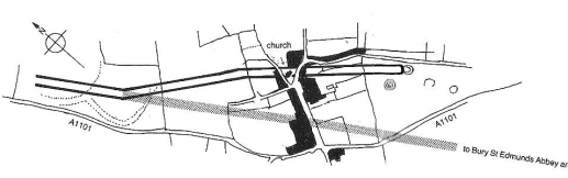
Forham (All Saints) Cursus, Bury St Edmonds,
Suffolk.
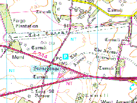 Stonehenge Cursus -
There are two Cursus at Stonehenge. The main cursus is aligned with
nearby Woodhenge, and can therefore be considered astronomical in nature
as the Stonehenge-Woodhenge alignment is orientated along the path of the
midsummer sunrise. (see Alignments
for more). Stonehenge Cursus -
There are two Cursus at Stonehenge. The main cursus is aligned with
nearby Woodhenge, and can therefore be considered astronomical in nature
as the Stonehenge-Woodhenge alignment is orientated along the path of the
midsummer sunrise. (see Alignments
for more).
The larger Stonehenge Cursus is now
known to be older then Stonehenge, having been dated at 3,500 BC by a team
from Manchester University. This discovery adds to the list of important
and sacred sites at which a Cursus monument can be seen to be superseded
by a Henge monument. (7)
(Click
here for large O/S map of Stonehenge Cursus)
Stonehenge Cursus (left), and Stonehenge lesser (Right).
New Pits Discovered in the Stonehenge Cursus.
Article: BBC News: Nov 2011.
Two previously undiscovered
pits have been found in the Stonehenge
Cursus which point to it
once being used as a place
of sun worship long before the
stones were erected. The
pits are positioned in such
a way that when viewed from
the 'Heel-Stone' at
Stonehenge, they would have
marked the rising and
setting positions of the sun
on the summers solstice.
(20)
It is thought the pits, positioned within the Neolithic Cursus pathway, could have formed a procession route for ancient rituals celebrating the sun moving across the sky at the midsummer solstice. Also discovered was a gap in the northern side of the Cursus, which may have been an entrance and exit point for processions taking place within the pathway. These discoveries hint that the site was already being used as an ancient centre of ritual prior to the stones being erected more than 5,000 years ago, the team said.
(Link
to Full BBC Article)
(Link
to Birmingham University Article)
Dorchester on Thames: Unfortunately, much of
its course has been destroyed by gravel quarrying and the construction
of the Dorchester bypass. It comprised two broadly parallel ditches
circa 60 metres apart, running for at least 1600 metres in a
more-or-less northwest-southeast direction. As with other prominent
Cursus, this one has a Henge associated with it, and one which measures
the same dimensions as the one at Stonehenge (366 MY circumference). An
antler from the primary fill has been dated to 3380-2920 BC
(calibrated), though whether this genuinely dates the Cursus
construction is open to debate. However, dating evidence recovered from
earlier and later monuments in the complex supports a broad 2nd half of
the 4th millennium BC date, in line with Cursus monuments generally.
(More
about the 'Dorchester Big Rings')
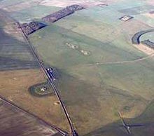
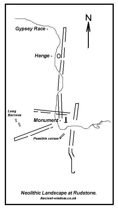 Rudstone cursus'- There are
four cursus' (possibly five) at
Rudstone,
all converging on the great menhir in the centre of the village (The
largest standing stone in Britain). The Rudstone complex offers us a
tantalising glimpse of the prehistoric ritual landscape, and reinforces
the idea that Cursus' may have had a ritual or ceremonial function. Rudstone cursus'- There are
four cursus' (possibly five) at
Rudstone,
all converging on the great menhir in the centre of the village (The
largest standing stone in Britain). The Rudstone complex offers us a
tantalising glimpse of the prehistoric ritual landscape, and reinforces
the idea that Cursus' may have had a ritual or ceremonial function.
(Click here to see the layout of the Rudstone Cursus')
Thornborough - The Thornborough cursus
was built over at around 3,000 BC with three henge-circles, suggesting that
the location itself already had a significance to the builders. This re-use of a
site combined with the later construction of Henges can be seen at other
sites such as Stonehenge, and the Dorchester-on-Thames Cursus (Both of which
share a common circumference of 366 MY, which is half that at Thornborough). The
Thornborough complex is now recognised as an important part of the 'ritual
landscape' in prehistoric Britain.
(Click here to see the layout of the Thornborough cursus)
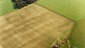
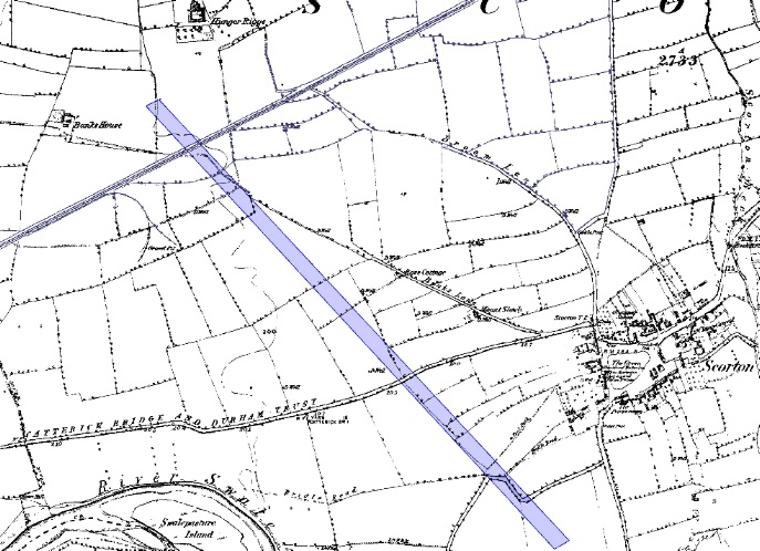
Scorton Cursus -
Several miles north of Thornborough. This cursus was
originally about 2.1km long and aligned SE-NW. Clustered round the
monument were a number of ring ditches, one that was excavated had a
single burial with a beaker. This would date the site as being in use from
around 3,500 BC until at least the Bronze Age c.2,000 BC. The Cursus was
cut almost 'dead-straight' over it's entire length and was 37.2m wide. The
Cursus was constructed by digging two parallel ditches 4.10m wide on the
east side and 3.90m wide on the west.
(Click here to see 1850 O/S map of Scorton)
Scottish Cursus.
The Twelve Apostles - The Twelve Apostles is Scotland's second
largest stone circle, and the seventh largest in the UK. The
importance of the area is reinforced by the fact that there were once two
long Cursus which passed close to the site.
(3)
Irish Cursus:
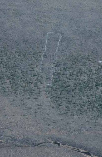
Newgrange cursus - The cursus is barely visible
today but extended around 100 m from the valley of the River Mattock to
climb the ridge occupied by the
Newgrange tomb. Here
it is rounded off by a terminal bank. The Cursus was around 20 m wide. The Boyne valley,
which includes Newgrange,
Knowth and
Dowth, is a huge celestial observatory,
enabling the builders to determine the phases of the solar and lunar
cycles. This reinforces the idea that Cursus probably served an
astronomical function. The Boyne Valley Cursus is orientated to the winter
solstice sunrise, as is the Newgrange passage mound.
(More about the Boyne Valley)
Loughcrew - Archaeological attention has
recently focused on the land below Slieve na Calliagh, in particular to
the north. Here Conor Newman noted for the first time a cursus-like
monument 150m SW of the Ballinvalley stone circle.
http://www.ucl.ac.uk/prehistoric/past/PAST051.pdf
Hill of Tara
- A reinterpretation of part of the earthworks at Tara suggests that the
site may be an example of the 'reuse' of sacred monuments.
(More about Tara Hill)
http://www.indigogroup.co.uk/edge/Absts1.htm
Welsh Cursus:
Spread eagle, Hay on Wye - In Alex Gibson's
description of the cursus monuments of Wales
(5), he describes this site
thus:
"A cropmark of two parallel ditches orientated SE-NW,
15m apart and traceable for some 130m. It runs perpendicular to the
present course of the River Wye 50m to the NE. No terminals are visible,
but there is a large ring ditch across the river 450m to the NW. A
closely-grouped cluster of some 8 ring ditches is visible on a gravel
terrace some 150m to the E," but adds finally that "the identification of
this site is suspect and may represent a fossil field system."
SO162378 (52� 1' 54.43" N,
3� 13' 18.05" W).
The Walton Green Cursus - The south west end of the
site is at SO26195978 and north east end is at SO26826001.
Measures 660m long by 30m wide, with squared ends and rounded
corners.
http://www.smr.herefordshire.gov.uk/hsmr/db.php?smr_no=22951
Hindwell is set in an area full of
Neolithic activity, including two cursus monuments.
http://www.britarch.ac.uk/BA/ba14/ba14news.html
Llandegai - Discovered as a crop-mark during the long
dry summer of 1959 by air photographers from Cambridge
University, the prehistoric burial and ritual complex at
Llandegai is among the most important prehistoric landscapes
anywhere in Wales. The air photo mapping shows the main
features: with two circular henge monuments dating to circa
3,000 BC and the parallel ditches of a roughly contemporary
cursus, or ritual avenue, to the right.
http://www.rcahmw.gov.uk/os/llandegai.shtml
Llandisillio - Aerial photography has
revealed an enclosure at Pencnwc while a most exciting
discovery, by Dyfed Archaeological Trust, has revealed a linear
crop mark across the village which may be evidence of a cursus �
part of some ceremonial complex, possibly dating from the
Neolithic period.
http://www.llandissilio.org.uk/local_history.html
Sarn-y-Bryn-Caled - The cursus complex
at Sarn-y-Bryn-Caled is a long, rectangular ditched enclosure
about 10 metres wide and 400 metres long. It has banks on the
outside of the ditches and was dated to the Neolithic
period about 3,700 BC.
http://www.gtj.org.uk/en/item1/21625)
Welshpool - An important complex of
prehistoric ritual monuments occupies the fields to either side
of Dyffryn Lane, Berriew, about 4 miles south of Welshpool in
the Severn valley. The earliest sites appear to be a Neolithic
long barrow and a nearby enclosure, both of which are known to
date to about 3,500 BC. Two possible rectangular timber house
sites might be of either Neolithic or early medieval date and
the complex also includes a possible Neolithic cursus monument
which, like many of the other sites, has been identified by
aerial photography.
http://www.britarch.ac.uk/cbawales/Newsletters/newsletter32/newsletter32.html
Brecknock - Another possible Cursus monument has been
identified in Brecknock, lying close to the River Wye at Pipton.
(Henges)
(Altered
Landscapes)
(Archaeoastronomy)
(Prehistoric
England Homepage)
|
.gif)