|
 The Alignment and Orientation of Prehistoric Sites:
|
It was a common
practice in prehistory to orientate and align constructions to
significant celestial objects or landscape features. They represent a communication between our ancestors and their
environment. This section of the site explores the themes most commonly
associated with these alignments and tries to interpret their meaning.
|
|
|
|
|
So common was the
orientation of ancient structures that in-fact, it is rare to find a site that wasn't orientated
towards something or other. Although by no means exclusive, it is evident
that orientation was an integral part of almost all ancient constructions,
endowing them with properties which presumably re-enforced the function(s) of these structures.
Solar orientations:
Although by no means exclusive, an extra-ordinary number of structures from around the
ancient world were orientated to face significant moments of the solar cycle
for thousands of years. Many sites also have suggestions of ritual, for
example, the Hypogeum on Malta contained the
remains of roughly 7,000 humans, and both the entrance and the 'Holy
of holies' within the underground necropolis were found to be orientated to
the winter solstice. Similarly, numerous of the Wessex long-barrows have
solar orientation such as the West Kennet long-barrow. This
intimate connection between death and the
orientation of structures towards the Sun was repeated around the ancient world.
Egyptian
Structures: A preference for solar orientation is clearly seen in early
dynastic Egypt with the combination of scientific precision and ceremony
resulting in the creation of the last surviving wonders of the ancient
world in the cardinally orientated Giza pyramids. Sites that have been
orientated in this way demonstrate a fundamental understanding of solar astronomy.
Sir Norman Lockyer noted that in Egypt, the majority of northerly sites
(i.e. Giza, Abusir), were cardinally
orientated to the equinoxes, whilst in the south (i.e. Karnak, Denderra), there was a
preference for orientation to the solstices.
Lunar orientations:
The orientation of sites to the solar cycle has been generally determined to have been
preceded by a preference for lunar orientation at several important sites
such as Stonehenge and
Carnac for example, both of which show a
transfer of orientation from lunar to solar at around 3,100 BC. It is now known that several of the
megaliths in the Carnac region were
re-used from earlier constructions which Alexander Thom demonstrated were
originally lunar. A particularly good example of this is the Lochmariaquer
complex at which one large menhirs from an original alignment of 19 stones,
is now understood to have been broken and re-used as capstones for the
Er-Grah, Table des Marchands and Gavr'inis passage mounds - all of which
were orientated to points of the solar-cycle.
(Click here for more on this subject)
The hundreds of recumbent
'circles' in Scotland demonstrate a preference for lunar orientation to phases of the lunar cycle,
specifically the midsummer full-moon
(2). In addition to
which:
'Statistical proof of
lunar alignments has now been provided by an exhaustive study of 276 sites
in Western Scotland. The monuments concerned are not stone circles but
free-standing lines formed of usually two or three stones. The analysis
showed a strong preference for lines to the south-east. This implies that
the structures were deliberately aligned on the southerly limit of the
rising moon in its monthly cycle'. (1)
It is
an interesting fact that the only recumbent circles found outside of
Scotland, are in the Ross-Carbery area of Ireland, which places them too
far south to make them any use as lunar observatories, and have in fact
been shown to be solar in their orientation. The
Drombeg RSC, where the sun has been
observed setting at midwinter (solstice), directly into a notch in the
landscape behind the recumbent stone.
(More
about Recumbent Stone Circles R.S.C's)
Pleiades (The Seven Sisters):
Alexander Thom suggested that certain sites he examined were orientated
towards the seven sisters, the rising of which signified the beginning of
the agricultural year throughout the ancient world. (Pleiades sits at the
centre of our galaxy).
Orion: Even
though Orion is not one of today's zodiacal constellations, it is one of the
most prominent in the night sky. The Egyptian fascination with Orion
(Osiris), formed an important part of their
mythology. It is interesting to note that while the Valley-temple at
Giza was dedicated to Isis, the similarly
styled Osireion at Abydoss was dedicated to
Osiris. Whether or not this has any bearing or association to the preference
for solar orientation (as mentioned above), is not yet understood.
(Orion Worship in Prehistory)
(More
about Archaeoastronomy)
There have been several suggestions
of evidence for prehistoric geometric alignments, that is - alignments
between ancient sites and/or landscape features which demonstrate
geometric principles.
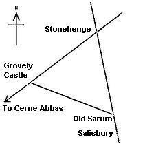
Sir Norman Lockyer made the first 'professional'
observation of geometry in the lay-out of the ancient
landscape. He realised that a geometric
connection existed between
Stonehenge,
Grovely (Grove-ley) castle and Old Sarum. The three form an equilateral
triangle
with sides 6 miles long. The Stonehenge-Old
Sarum line is continued another 6 miles to the site of the present Salisbury
Cathedral, then the Clearbury rings and Frankenbury, while the
Stonehenge, Grovely castle
line is also astronomical as it is orientated along the path
of the summer solstice, and also connects other ancient sites.
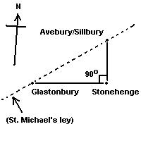
Stonehenge has been shown to be connected to other sites
through geometry. In particular, the connection between
Stonehenge, Glastonbury
and Avebury, which also
extends onwards to other important megalithic sites such as
Arbor Low, which sits
exactly 1�
east and 2�
north of Glastonbury. The Glastonbury-
Avebury line is orientated along the line of the summer
solstice and the Glastonbury-Stonehenge line is also a part of
the great 'Decagon' discovered by
John Michell.
(More about
Geometric alignments)
(More
about English Geodesy)
(Geodesy
Homepage)
A look at some of the more popular
theories proposed to explain the frequency of alignments between
natural objects and megalithic constructions.
Most cultures have traditions and words to describe the
straight, often geometrical lines that run across landscapes, connecting ancient
or sacred features together. Usually the names given to represent these
invisible lines are translated to an equivalent of 'spirit', 'dream', or
'energy' paths. Apart from the physical presence of these connected sites however, little remains
from which to deduce much about their origin or purpose.
Their existence was suggested in
1921 by the amateur archaeologist Alfred Watkins, whose book The Old
Straight Track brought the alignments to the attention of
the wider public. He said of them:
"It is quite useless looking
for existing fragments, however old, of roads which may remain
from the first track, although, as we shall see, some bits may
form useful indications of its site. The changes from early
days have been so many in the matter of roads. We must
therefore clear our minds, not only of what we think of roads,
even Roman ones, but of our surmises, and begin again."
(4)
(More about Ley-lines)
How far do alignments
extend, and what is their relationship to each other.
The idea
that there may have once existed a so called 'World-grid' has been
explored by several people in the past.
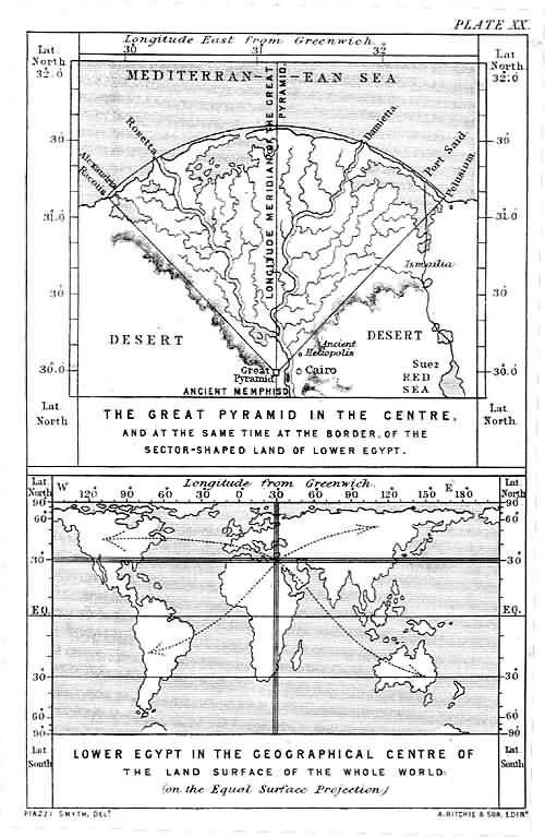
Flinders
Petrie was the first respected European to conclude that Giza complex
had been placed geodetically, at the 'Geographic centre of the
land surfaces of the whole world'.
This theory has been expounded by several researchers including
Hancock and in particular Livvio Stecchini, who's work was highlighted
by Peter Tompkins (3), who had the following to say on the subject:
'Because
of the advanced geodetic and geographic science of the Egyptians, Egypt
became the geodetic centre of the known world. Other countries located
their shrines and capital cities in terms of Egyptian 'zero' meridian,
including such capitals such as Nimrod, Sardis, Susa, Persepolis, and
apparently, even the ancient Chinese capital of An-Yang... As each of
these geodetic centres was a political as well as geographical 'navel'
of the world, an Omphalos or stone navel, was placed there to represent
the northern hemisphere from equator to pole, marked out with meridians
and parallels, showing the direction and distance to other such navels'.
(More on the World-Grid)
Interestingly, it has been recognised that the
corners of the 3rd -5th Dynasty Pyramids were all built so as to
align to Heliopolis, even those at Giza. This clearly suggests that
Heliopolis was recognised as the
'Omphalos' of its time.

The Alignment of Pyramid Corners towards
'Innu', or Heliopolis - (The place
of creation).
(More on this
Subject)
With so much orientation and aligning
going on, why do some sacred sites appear to be orientated
almost cardinally. Deviations of 5� - 8� are found commonly around the
world. Is this simply the result of a magnetic bearing, or perhaps something
else?
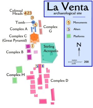
Archaeological site plan for La Venta.
Notice how the site is aligned slightly west, (8� west of north). Several
Mesoamerican sites have this alignment, including San Jose Magote.
(More about La Venta, home of
the Colossal Stone Heads)
(Geometric
Alignments)
(Prehistoric
Geodesy)
|