|
 The Great Decagon:
(Geometric Landscape Alignment )
The Great Decagon:
(Geometric Landscape Alignment )
John Michell revealed
the existence of a large scale geometric figure across
southern Britain
and Wales in his book
�City of revelation�.
John Michell demonstrated that the ancient Celtic �perpetual
choirs� at Llantwit manor, Glastonbury Abbey and Stonehenge were 'three
vertices of a regular decagon of majestic proportions. A fourth vertex
exists at Goring-on Thames where a major pagan temple once stood at the
junction of several important track ways'. The centre of the decagon is
at the apparently insignificant hamlet of Whiteleaved Oak where the former
counties of Hereford, Gloucester and Worcester come together.
As this
figure has been referenced in various books, it is worth investigating its
existence and accuracy.
The following is the
Original list
of the Lacations of the decagon and their Long/Lat coordinates:
|
Location |
Latitude |
Longitude |
O/S |
Notes |
|
Whiteleaved Oak (Centre)
|
52˚ 01' 20" |
02˚
21' 03" |
SO759355 |
Three County Border. |
|
Glastonbury |
51˚
08' 47" |
02˚
42' 54" |
ST500387 |
'Sacred Heart' of England. |
|
Stonehenge |
51˚
10' 42" |
01˚
49' 29" |
SU120420 |
Stonehenge (Astronomy). |
|
Goring |
51˚
31' 56" |
01˚
07' 58" |
SU603817 |
Junction of Icknield/Ridgeway.
'choir-place' |
|
Stony Stratford |
52˚
04' 01" |
00˚
54' 08" |
SP753415 |
|
|
Croft Hill |
52˚
35' 17" |
01˚
13' 55" |
SP521992 |
|
|
Uttoxeter* |
52˚
53' 25" |
01˚
59' 45" |
SK003324 |
|
|
Ellesmere* |
52˚
51' 19" |
02˚
54' 08" |
SJ393290 |
|
|
Carno/Gors Goch* |
52˚
30' 15" |
03˚
36' 16" |
SN912907 |
|
|
Llandovery |
51˚
57' 47" |
03˚
50' 06" |
SN740309 |
|
|
Llantwit Major |
51˚
26' 31" |
03˚
30' 20" |
SS956727 |
(See below) |
(Ref:
Measure of Albion. J. Michell, Heath;. Appendix 6)
The 'Ancient Choirs'
At present, only three of
the proposed sites are substantiated by documentation, the others remain
speculative.
The earliest reference to 'Britain's
Perpetual Choirs' is in the 1796 edition of a translation of FABLIAUX (TALES)
which includes
a four line Welsh text (known as a Triad - or 'triade'), and an English
translation of it. The theme is the Perpetual Choirs of Britain, and the
three sites given in the translation are the 'Isle of
Avalon' (Glastonbury), 'Caer Caradoc' (Salisbury) and 'Bangor Iscoed'
(Disputed). (7)
John Michell, places the
three Choirs at Glastonbury, "The choir of Ambrosius" (Stonehenge)
and the third at Llantwit Major in South Wales.
In 1801, Iolo Morganwg recorded that 'in
each of these choirs there were 2,400 saints; that is there were a hundred
for every hour of the day and the night in rotation, perpetuating the praise
and service of God without rest or intermission.' The function of the
choirs was to maintain the enchantment and peace of Britain. However,
it must be stated that in all the ancient literature the choirs were referred to as a
'Triad'.
|
Consideration of the Proposed Locii: |
The following information was obtained with the aid of
1:50,000 O/S Maps and computer software - 'O/S Map of UK - 4th edition'.
|
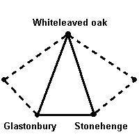
Whiteleaved Oak (WLO) - (OS Grid Ref: SO760357) - (Centre of the
decagon, Perpetual Choir).
Significance- The
village of Whiteleaved Oak sits on the junction of three county
borders (Hereford,
Gloucester and Worcester).
It is situated almost exactly on the 52nd latitude (52˚ 01' 20"
N). It is referred to as an 'Ancient Choir' by
John Michell.
(View Whiteleaved Oak on the 1891-2
O/S Survey Map).
(More
about Whiteleaved Oak)
Glastonbury (GL)
-
(OS Grid Ref: ST515385)
- (The 'Heart of England',
Perpetual Choir)
Significance - Glastonbury is
traditionally known as the sacred 'Heart of England', and it lies on the
St.
Michael's-ley. It is believed to be the resting place of the Holy-grail,
Of King Arthur, and was the place where Joseph of Arimea came and planted
his staff.
|
Glastonbury to Centre (WLO). |
100.4 Km. |
|
Glastonbury to Stonehenge (SH). |
60.8 Km. |
|
Glastonbury to Llantwit Major (LM). |
See Llantwit below. |
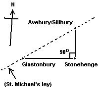 Note: The line from Glastonbury to Stonehenge is also one of the
lines of the Right-angled triangle formed when the two are connected to
the Avebury/Silbury Hill complex.
Note: The line from Glastonbury to Stonehenge is also one of the
lines of the Right-angled triangle formed when the two are connected to
the Avebury/Silbury Hill complex.
(View Glastonbury on the 1888 O/S Survey Map).
(More about Glastonbury
Tor).
Stonehenge (SH) -
(OS Ref: SU121420) - (Perpetual
Choir)
Significance - Stonehenge is known
to have been constructed for astronomic purposes. The site has a secondary
geometric association with Glastonbury (GL.), as shown above.
|
Stonehenge to Centre (WLO). |
100.5 Km. |
|
Stonehenge to Glastonbury (GL). |
60.8 Km. |
|
Stonehenge to Goring-on-Thames (GoT) |
60.5 Km. |
Note: Both
(SH) and
(GL) are similar in distance
from
the centre (WLO),
to within 1/1000th part. Therefore creating an almost perfect isosceles
triangle.
(View Stonehenge on the 1887 O/S
Survey Map).
(More about Stonehenge).
The
'Great Decagon' of England.
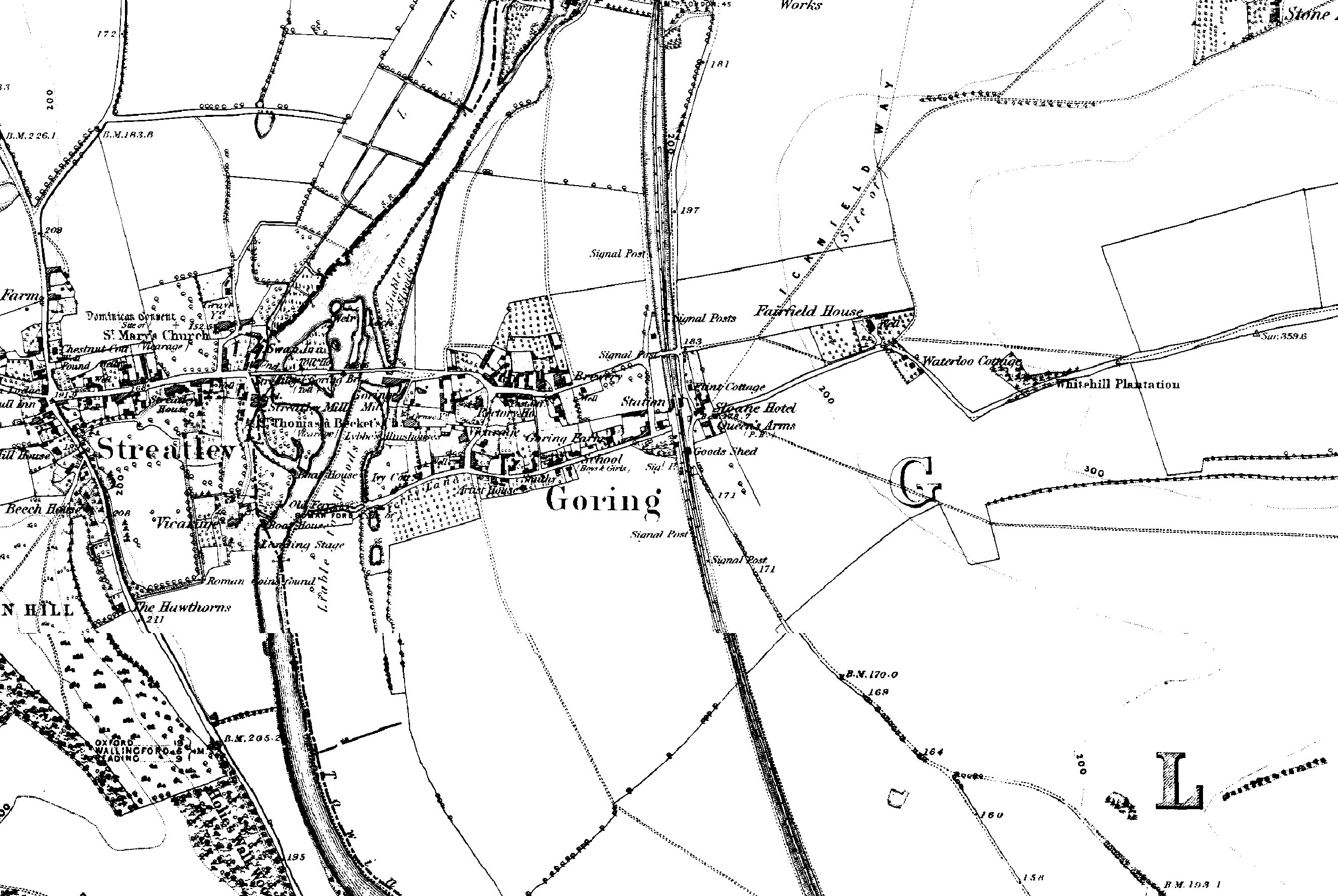
Goring-on-Thames (GoT)
- (OS Ref: SU594796) - (Junction of Icknield way and The Ridgeway).
Relevance- The next in line after Stonehenge is Goring-on-Thames, which
sits at the junction of the 'Icknield Way' and the 'Ridgeway', John Michell
talks of a pagan temple at this crossing point of these two
important prehistoric tracks.
|
Goring to Centre (WLO). |
100.3 Km. |
|
Goring to Stonehenge (SH). |
60.5 Km. |
|
Goring to next proposed loci. |
See below - Personal research. |
Note: Goring
(GoT) is similarly distanced to within
3/1000th's.
(Still extremely significant)
(View
Goring on the 1882 O/S
Survey Map).
And then...
Stony Stratford (SS)
-
coming soon
Croft Hill (CH) -
coming soon
Uttoxeter (UX) -
coming soon
Ellesmere (EM) -
coming soon
Carno/Gors Goch (GG) -
coming soon
Llandovery (LV) -
coming soon
Until ...
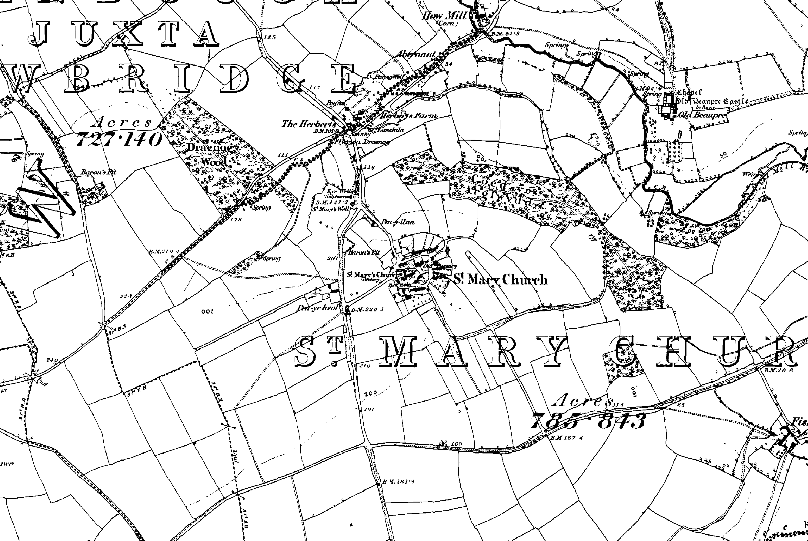
Llantwit
Major (LM) -
(OS Ref: ST968687 - Town centre)
Relevance -
This site is also mentioned as an 'ancient Choir' by Michell, associating it
with the Celtic tradition of 'choir's', or monasteries, assisting the
supporting of the heavens with their perpetual chanting and prayer. The
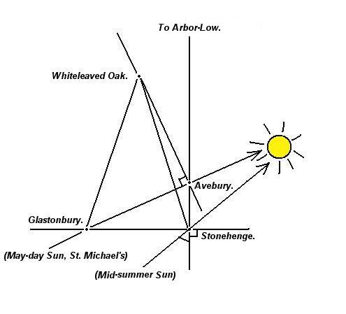
alignment formed by Llantwit Major, White Leaved Oak and Croft Hill follows
the path of the sun on the Midsummer Solstice.
(Llantwit to Croft Hill via White leaved Oak
|
Llantwit to Centre (WLO). |
103.8
Km |
|
Llantwit to Glastonbury (GL). |
62.5
Km |
|
Llantwit to next proposed loci. |
|
Note:
Assuming these placements to be deliberate, and considering the level of
accuracy obtained for the other sites it is clear that the
accurate placement between
other locii is not repeated at Llantwit (LM). It seems curious that Llantwit does not show the same
level of precision, a point that needs to be examined.
(View Llantwit Major on the 1885
O/S Survey Map).
Note:
While Llantwit Major does not fit have the same geometric precision of the
other Locii, the town of St. Mary's Church (SMC) slightly
further north of
it does.
St. Mary's Church
(SMC) - (OS Ref: ST995707)
Relevance: Locations dedicated to
St. Mary are associated with the St. Michael's ley-line, which is in turn
associated with the 'Decagon', however, this location is not mentioned in
the Welsh Triads, while nearby Llantwit Major is. This location requires
further confirmation.
|
Distance to Centre (WO). |
100.3 Km |
|
St. Mary's to Glastonbury (GL). |
60.9 Km |
(View St. Mary's Church on the 1885
O/S Survey Map).
|
Conclusions:
The first four named
named
sites (WLO, SH, GL and GoT) are geometrically related within 5 parts in a 1000
which is an extremely high significance
ration.
All the selected sites
have prehistoric remains present however, the relationship between sites appears to be
geometric and not physical as there are no routes between locations, and apart from the
mention of three in the Welsh Triads, they appear to have no
common factor that unites them.
Observations:
The geometry of the decagon
shows no preference for a cardinal alignment, instead it is orientated so
that its NW and SE faces are orientated along the zenith of the Midsummer
solstice sun.
Whiteleaved Oak sits
(almost exactly) on the 52nd latitude
(52˚ 01' 20").
There is a connection
between the geometry of the Decagon, and the St. Michael's ley-line.
|
Other Examples of Geometric Alignments
|
Shape |
Location |
Discoverer |
Select |
|
Equilateral triangle |
Salisbury, England |
Sir N. Lockyear |
View |
|
'Decagon' |
England-Wales |
J. Michell |
View |
|
Maltese cross |
Mediterranean |
M. Chattelain |
View |
|
Equilateral triangle |
France |
M. Chattelain |
View |
|
2x Rose de Vents |
France |
Xavier Guichard |
Viev |
|
Heptagon |
Wessex, England |
Chrichlow (1) |
View |
|
Squaring the circle. |
London, England |
C. E. Street (2) |
View |
|
Multiple |
Oracle centres |
Livvio Stecchini |
View |
|
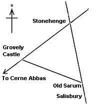
Equilateral triangle |
Southern England |
Personal observation |
View |
|
Equilateral triangle |
England-France-Ireland |
Personal observation |
View |
|
Isosceles triangle |
Southern England |
Personal observation |
View |
Note: The 'heptagon' above has been
discerned as embracing Wessex, however, the two most southern points would
only have been on dry land before 6,000 BC (1)
Ilkley Moor Triangle
- Three stone circles form an equilateral triangle on Ilkley Moor, being
separated by exactly 1,180 yards each. They are: The Twelve Apostles, The
Blackstones and The Grubstones. Flashing lights and other curious phenomena
have been reported several times over The Twelve Apostles.
(4)
(More
about Geometric Alignments)
|
In the case of
the 'Decagon' it can be seen that the measurements between nodes
are all based on a two dimensional model of the earth (one that
doesn't account for the spherical shape of the earth). The only
points of the Decagon which can be established with any
certainty are Whiteleaved Oak, Stonehenge, Glastonbury and
possibly Goring on Thames. It is therefore interesting to note
that Glastonbury and Stonehenge do have a geodetic
relationship to each other (when viewed in relation with other
important sites such as the Avebury/Silbury complex), which
appears to show a separation between several of the most
significant British megaliths in units of exact degrees. This
particular finding is significant as the length of a degree of
latitude and a length of a degree of latitude vary from location
to location on the globe.
Glastonbury
is exactly one degree west of Arbor Low, which is exactly two
degrees north of Stonehenge. Avebury is separated from
Stonehenge by exactly a quarter of a degree of latitude.
(Prehistoric British Geodesy)
|