|
 Ley-lines:
('Ley','lea' - 'A clearing') Ley-lines:
('Ley','lea' - 'A clearing')
('Heilige
Linien' to the Germans 'Fairy
paths' to the Irish, 'Dragon Lines' to the Chinese, 'Spirit Lines' to
Peruvians and 'Song Paths'
to the Australian Aborigines - and so on around the world).
Most cultures have traditions and words to describe the
straight, often geometric alignments that ran across ancient landscapes, connecting
both natural and sacred prehistoric structures together. Usually the names given to represent these invisible lines are translated to an equivalent of 'spirit', 'dream', or
'energy' paths. However, apart from the physical presence of the sites
themselves, proving the presence of a 'connection' between them is
something that researchers have found notoriously elusive.
Amongst the widely
differing (and often simplistic) theories that attempt to explain why
ley-lines and landscape alignments first appeared, the following theories
probably say as much about us now as at any time in the past, yet we are bound to
acknowledge and respect the following writers opinions and conclusions as 'they', the following
few, are the giants upon whose shoulders this field of study current sits:
|
The
Definition of a Ley-line: |
Even though the term 'Ley-line was originally conceived
by Alfred 'Watkins, by 1929, he had discarded the use of the
name 'ley' and referred to his alignments only as 'old
straight tracks' or 'archaic tracks'
"It is quite useless looking
for existing fragments, however old, of roads which may remain
from the first track, although, as we shall see, some bits may
form useful indications of its site. The changes from early
days have been so many in the matter of roads. We must
therefore clear our minds, not only of what we think of roads,
even Roman ones, but of our surmises, and begin again." -
Alfred Watkins (4)
'Ley lines
are hypothetical alignments of a number of places of
geographical interest, such as ancient monuments and
megaliths. Their existence was suggested in 1921 by the
amateur archaeologist Alfred Watkins, whose book 'The Old
Straight Track' brought the alignments to the attention of
the wider public'.
This explanation by no means completes the
modern definition of a ley-line, as we cannot say for example that all alignments of
stones are ley-lines, however old they are. Nor
does it follow that all ancient sites were aligned
deliberately, even those that appear to have been.
Alfred Watkins, the modern
founding father on the subject, created the first basic set of
guidelines in order to describe ley-lines according to his
perception. As we have learned more about ley lines, so we have had
to adapt these original guidelines in order to explain our
findings, whilst keeping to the context with Watkins' original
ideas.
The following natural and man-made
features were suggested by Watkins to be reliable ley-markers:
Mounds, Long-barrows, Cairns,
Cursus, Dolmens, Standing stones, mark-stones, Stone circles,
Henges, Water-markers (moats, ponds, springs, fords, wells),
Castle, Beacon-hills, Churches, Cross-roads, Notches in hills,
Camps (Hill-forts),
Any true Watkinsian ley requires
it to have a start (or finish) point in the shape of a hill.
(4)
From map and fieldwork,
Paul Deveraux concluded
that all Henges
are likely to indicate the presence of a Ley.
(2)
We can
therefore begin to gauge the strength of a ley-line according to its length, accuracy of deviation, number
of ley-markers and their individual significance. We can also
separate ley lines into basic categories such as astronomical,
funerary, geometric etc, as the following examples illustrate:
(Return
to the top)
|
What
was the Original Purpose(s) of Ley-lines? |
There are several developed theories on the
purpose of ley-lines,
many of which offer valid potential; something which in itself illustrates the complexity
of unravelling the myriad of alignments from several millennia of activity.
It is likely that ley-lines are
a product of different elements from several of the following theories, being
created at different times, for different purposes. The following examples are
the current contenders for explaining how such a dedication to straight-lines
has led mankind its present position.
It is important to recognise
the distinction between ley-lines and geometric alignments.
 Although there is little
direct evidence for 'religious' worship in the modern sense of the word at megalithic sites, there is certainly evidence that
funerary rites were involved at several important locations (some of which may
be classed a secondary use). The burial of
valuable goods alongside funerary remains, placing of remains inside stone
chambers underground, and alignment of funerary structures or their inhabitants
with the rising sun, all attest to the fact that funerary ley-markers were not
placed according to
purely 'scientific' criteria, although they may also have been added to existing
pre-existing ley-lines.
A number of rituals and traditions have been associated with the path taken by
funerary parties. Traditionally known as 'death roads' (dood-wegen or geister-wege).
The fact that 'spirit paths' are traditionally straight and seem to include the
same 'markers' as ley lines significantly increases the argument for some of the
leys having once served this function. Spirit lines are also invisible, and are
viewed as 'tracks' or 'paths' for the movement of the spirits, which may explain
why markers are often not visible from one location to another (an argument traditionally
used against the existence of leys themselves).
Funerary Traditions:
Watkins mentions the English funerary tradition of stopping at a
crossroads and saying a prayer, a custom still practiced to this day. Other
customs involve walking around or 'bumping' churches and stones en-route. Processions are not
supposed to carry a corpse twice over the same bridge and custom forbade singing
or music on a bridge Another interesting funerary-custom, still practiced
into the 20th century was for mourners to carry a pebble and when they passed
certain spots, throw
their pebbles into a pile of previous mourners pebbles.
The 'Fairy paths' of
the Irish also have folklore associated with them. There are numerous stories of
houses being built over Fairy-lines and being then being destroyed or cursed.
Stones, crosses, crossroads, bridges and Churches are all the same points on
Watkins list of ley-markers, although it is probable that many of the alignments that involve churches and
cemeteries, or which pass areas with traditional funerary rites or death rituals
have been mistakenly classified as 'ley lines' as funerary paths are not
necessarily always straight.
Many important ley-markers are associated with springs and water
sources.
The Chinese art
of 'Feng-shui', or 'wind and water', also means 'that which cannot be seen and
cannot be grasped'. The duty of the practitioners of the art was to determine
the flow of 'lung-mei', or 'Dragon currents'. Every building, stone and planted
tree was so placed into the landscape as to conform to the 'dragon currents'
which flowed along these lines. The main paths of the forces were believed to be
determined by the routes of the sun, moon and five major planets. We know that the
Earth is encompassed within a magnetic field. The strength and direction of the
magnetic currents vary according to the position of the sun, moon and closer
planets. The magnetic field is also affected.
It is possible that this
field may have been
detected (i.e. through dowsing),
and mapped out in the past. Noobergen
(6), reminds us that the earths natural
magnetism was believed to have been used to re-fertilise the soil, in the same
way as the
aborigines did with their 'turingas' or 'dream lines'. He also mentions that
there is scientific research that shows that water is extremely sensitive to electromagnetic
fields, and that as the fields are changed or influenced, so the chemistry of
the water may be altered too. Horticulturalists have discovered that plants
placed within a magnetic field grow more than six times faster than in normal
conditions. We are able to show today that the strength and direction of the
Earths magnetic currents vary according to the positions of the Sun, Moon and
other planets.
The fact it took so long for us to realise that astronomy was
in any way involved with megalithic culture is almost as surprising as the
fact that it was ever forgotten. Although there
has been a traditional resistance to this theory from the scientific
establishment, we live in a time when it is finally accepted that many of the
larger megalithic constructions were designed so as to be able to accurately
identify celestial objects or measure their cycles.
The clear link between megaliths and astronomy can also be
said for megaliths and ley-lines, as they are often found to be prime ley-markers,
and intersections of several ley-lines (i.e.,
Arbor-Low,
Avebury,
Stonehenge
etc).
One of the largest Leys in England, the
so-called St. Michaels Ley, is aligned along the
path of the sun on the 8th of May (The spring festival of St.
Michael) and can therefore be considered
astronomical. This line passes through several megalithic sites before it
reaches Glastonbury,
(artificially shaped to follow the direction of the ley), and then on to the
Avebury/Silbury complex, both significant English landscape features.
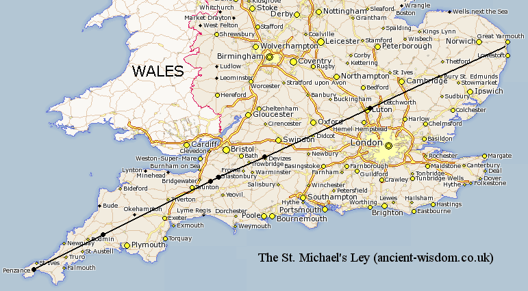
The St. Michael's Leyline
follows the path of the Sun on the 8th May (The spring festival of
St. Michael).
(More
about St. Michael)
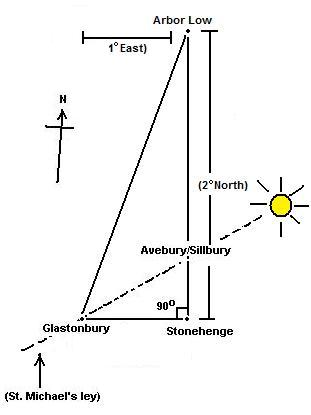 The
St. Michael's ley has been shown to be inter-related with several
other prominent British megaliths through geometry, astronomy and an
apparent knowledge of longitude/latitude, not least of all to
Stonehenge. Stonehenge,
whilst not being a part of the St. Michael ley, is connected with both
Glastonbury and Avebury/Silbury through geometry, and also forms the crossing point
of several prominent ley-lines - both astronomical and non-astronomical. The first astronomically significant ley-line
to pass through Stonehenge was first identified by Sir Norman Lockyer, and later
extended to 22 miles in length by K. Koop. This ley follows the path of the
mid-summer sunrise on a bearing of 49� 15'. (2) The
St. Michael's ley has been shown to be inter-related with several
other prominent British megaliths through geometry, astronomy and an
apparent knowledge of longitude/latitude, not least of all to
Stonehenge. Stonehenge,
whilst not being a part of the St. Michael ley, is connected with both
Glastonbury and Avebury/Silbury through geometry, and also forms the crossing point
of several prominent ley-lines - both astronomical and non-astronomical. The first astronomically significant ley-line
to pass through Stonehenge was first identified by Sir Norman Lockyer, and later
extended to 22 miles in length by K. Koop. This ley follows the path of the
mid-summer sunrise on a bearing of 49� 15'. (2)
Another significant ley-line to pass through Stonehenge was
also identified by Lockyer, and can be shown
to extend accurately for 18.5 miles. It skirts only the edge of the henge at the
junction of the avenue, missing the centre (and the sarsen stones) altogether.
This line runs on a bearing of 170� 45', and appears to have no astronomical significance.
The alignments at S tonehenge
therefore appear to offer a fusion of
funerary, astronomical and geometric practices, simultaneously connecting three of the most significant
locations in southern England. Glastonbury, Stonehenge and Avebury/Silbury, which
all align
to create a perfect right-angled triangle, accurate to within 1/1000th part. It
is from this historic starting point that we can begin unravelling the complexity of prehistoric geometry of the British
landscape.
(More about Archaeoastronomy)
:
The previous
examples have offered a indication that geometry might be involved in the
orientation of some ley-lines. It is arguable that as many of the sites are aligned astronomically, and as
geometry is a natural product of astronomy, the effect might be a product of
'automatic' or 'accidental' geometry within the layout of certain sites,
but this does not explain geometry between sites which certainly involves
surveying techniques, which in turn requires deliberate and applied mathematics
(logarithms and trigonometry or their equivalent).
Sir Norman Lockyer
(Astronomer-Royal), was the first 'respectable' person to recognize
geometry in the ancient English landscape. He
noticed
the geometric alignment between
Stonehenge, Grovely (Grove-ley)
castle and Old Sarum (The site where the original Salisbury
'cathedral was built). The three form an equilateral triangle
with sides 6 miles long, with the Stonehenge-Old Sarum
line continuing another 6 miles to the site of the present Salisbury Cathedral,
and beyond.
This extremely
significant finding shows both that the early megalithic builders were aware of
both astronomy and geometry, and combined them deliberately into their
constructions. At the same time as this reasonable astonishing revelation, we
are able to see how many ley-markers may have been introduced along pre-existing
alignments, and it is important to know the origin of all the markers on
ley in order to accurately determine its origin and purpose.
The
megalithic tradition in the British Isles can apparently be traced back to at
least 3,000 B.C., if not earlier still. This tradition seems to have been based
on a very sophisticated philosophy of sacred science such as was taught
centuries later by the Pythagorean school. As
Professor Alexander Thom observes in his book Megalithic Sites in Britain
(1967): �It is remarkable that one thousand years before the earliest
mathematicians of classical Greece, people in these islands not only had a
practical knowledge of geometry and were capable of setting out elaborate
geometrical designs but could also set out ellipses based on the Pythagorean
triangles.�
(More about
Geometric Alignments)
The Aborigines
of Australia tell of a 'pastage', which they call the 'dream-time', when
the 'creative
gods'
traversed the country and reshaped the land to conform with important paths
called 'turingas'. They say that at certain times of the year these 'turingas'
are revitalised by energies flowing through them
fertilising the adjacent countryside. They
also say that these lines can be used to receive messages over great distances.
The Incas used 'Spirit-lines' or 'ceques'
with the Inca temple of the sun in Cuzco as their
hub. (9)
The Jesuit father Bernabe Cobo referred to these 'ceques'
in his 'History of the new World'. 1653. These were lines on which 'wak'as'
were placed and which were venerated by the local people. Ceques were described
as sacred pathways. The old Indian word 'ceqque' or 'ceque' means boundary or
line. Cobo describes how these lines are not the same as those at Nazca, being
only apparent in the alignment of the wak'as. These wak'as were most often
in the form of stones, springs, and often terminating near the summits of holy
mountains. Documentary records made by the Spanish record that 'qhapaq Hucha'
ceremonies of human sacrifice (usually children), took place at wak'as as an
annual event and also at times of disaster. In the 17th century the Roman
catholic church ordered that the holy shrines along the routes be destroyed. As
in Europe, many ancient holy places were built over with churches.
Elsewhere in
America, fragments of ancient tracks can still be found such as the Mayan
'Sache', of which 16 have so far been found originating in Coba,
Mexico. The following is a description of one found
in the Yucatan;
'...a great
causeway, 32ft wide, elevated from 2-8 ft above the ground, constructed of
blocks of stone. It ran as far as we could follow it straight as an arrow, and
almost flat as a rule. The guide told us that it extended 50 miles direct to
Chichen itza (it started from the other
chief town of Coba) and that it ended at the great mound, 2km to the north of
Nohku or the main temple in a great ruined building'.
(3)
Other ancient
tracks have been found in New Mexico. These roads are barely visible at ground
level and radiate from
Chaco Canyon.
As in Bolivia, some of these paths run parallel and others lead to nowhere. One
of the major sites connected by the 'Anasazi' roads is Pueblo Alto.
The German equivalent of ley lines is 'Heilige
Linien', or 'holy lines'. The area of 'Teutberger Wald', also known as the
'German heartland' has a significant network of these lines which include the
Externsteine and the megalithic stone circle at Bad Meinberg.
It has been suggested that there are enough
prehistoric sites to play statistical 'dot to dot' with, and that a survey of
English pubs and telephone boxes will yield the same level of statistical
probability as determined by ley-hunters. This is a reasonable point and
therefore needs to be remembered at all times. The argument of random chance is
countered by the addition of folk-lore and tradition associated to ley-markers
and through exhaustive research that has enabled predictions of locations of
ancient tracks and ley-markers to have been later substantiated through
archaeology. (4)
(Return
to the top)
|
When were Ley-lines
First Made.
|
Exactly how old the original straight paths were is a matter of
debate. We can read of ley-lines connecting offshore beneath the English channel
(1), upon which basis, Behrand concluded that these particular leys must have
been marked out between 7,000 BC and 6,000 BC.
We know that the European landscape was
significantly redesigned using geometric principles in the middle ages by the
Cathars, Knights Templar and the Holy church of Rome. We also know
that a large number of the great Cathedrals Churches and Holy sites were built over
earlier pre-existing pagan sites and constructions (Xewkija,
Knowlton,
Rudstone
etc) The re-use of ancient sites can even be seen to extend back to
pre-historic times such as the re-use of several large menhirs as capstones for
passage-mounds in the Carnac region. It is this
simple fact, combined with the observation that these same megalithic structures
are invariably found to be the ley-points along which such lines are determined,
that places the origin of ley-lines into the prehistoric past. (It by no means
follows that all megalithic sites were placed on ley-lines).
It is not uncommon to find the terms
'ley-lines' and 'roman roads' in the same context, but it is important to draw a
distinction between the two, as there is absolutely no pre-requisite for a
ley-line to include roads, pathways, or any visible connection between
ley-points of any kind whatsoever. It is the case however, that some ley-lines
have been identified along which ancient paths or roads follow (or run
alongside), and it is perhaps worth first considering the origin of these
ancient tracks, and their connection with ley-lines.
In the first place, many of the long
straight roads of Britain have been classified incorrectly as 'Roman Roads'. A
fact that can be proven through their existence in Ireland, as noted by J. Michell,
who pointed out that '...these same roads exist in Ireland, a
country which never suffered Roman occupation..', then also noted the fact
that '...beneath the Roman surfaces of the Fosse Way, Ermine Street and
Watling Street excavators have uncovered the paving stones of earlier roads,
at least as well drained and levelled as those which succeeded them'.
The same observation was made in other parts
of Europe by the Romans themselves, who
in their conquest of the Etruscans,
noted standing stones set in linear patterns over the entire countryside of
Tuscany. Romans also record discovering these 'straight tracks' in almost every
country they subjugated: across Europe, North Africa, Crete, and the regions of
ancient Babylon and Nineveh. Fairly conclusive then - the roads existed
before the Romans. In fact, considering the scale of development in the
Neolithic period approx 5,000 - 3,000 B.C. it is quite likely that they (or the
first, or some at least), existed at that time too, if only to connect sites.
|
A Chronology
of European Geomancers. |
In
1740, Dr.
William Stuckley,
first noted that the axis of Stonehenge and the Avenue leading from it point
to the north-east, 'whereabouts the sun rises when the days are longest'.
He perceived the whole British landscape as laid out according to a sacred
'druidic' pattern, and etched with symbols of serpents and winged discs. At
Barrow near Hull he found a great earthwork representing a winged circle,
its trenches arranged so as to measure the seasonal tides of the Humber
Estuary. He disclosed another near Navestock Common in Essex which now lies
forgotten in a small wood, near the northern most Central-Line terminal. In
his book on Avebury, Stuckley wrote:
'...They have made plains
and hills, valleys, springs and rivers contribute to form a temple three
miles in length...They have stamped a whole country with the impress of this
sacred character'.
William Black
-
In the 1800's, an expert
on roman roads announced his theory that he had uncovered a whole system of 'grand
geometric lines', radial and polygonal, which ran across Britain and beyond.
He pursued his studies for fifty years before releasing the theory. They linked
major landmarks in a precise manner, even defining the boundary markers of
counties. Black died in 1872. (4)
Sir Montague Sharp
-
Working in the early years of the 20th century, he discovered a network of
rectangles in Middlesex and became aware that ancient churches, which he
recognised as marking pagan sites, fell on alignments.
(2)
In
1904,
F. J. Bennet
-
Published the findings on what he called the 'Meridianal lines'
in Wiltshire and Kent, which apparently linked prehistoric sites and ancient
churches in generally N-S alignments, often with regular divisions, based on the
mile, between sites.
(2)
 In
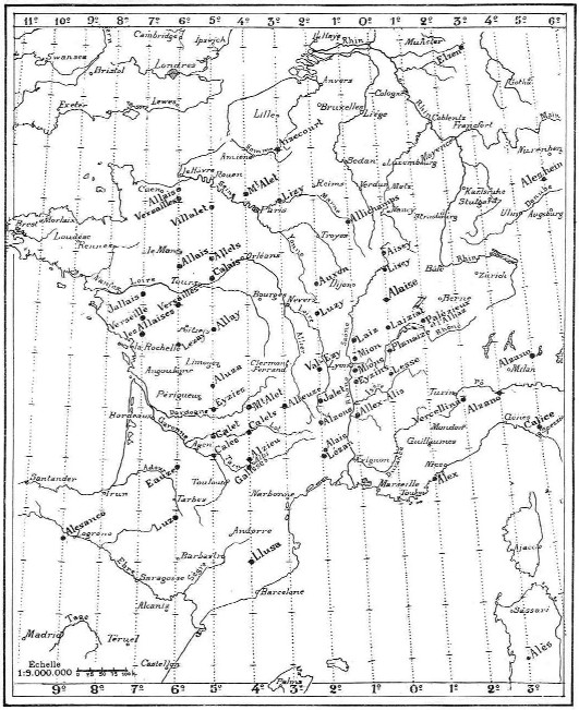
1911,
Xavier Guichard
- The French philologist started
researching the origins of ancient European place-names. He came to the
conclusion that there were three basic root names: Burgus, Antium
and
Alesia, of which the last was unique as never having been given to a
town or village founded in historic times. In its Greek form of
Eleusis, the word dated from the legendary pre-Homeric times; in its
Indo-European roots, Ales,
Alis or Alles meant a meeting point to which people travelled. His
research explored derivatives of the word 'Alesia' as far afield as
Egypt (Eleusis on the Nile Delta) and Poland (Kalisz), with the highest
concentration in France. Guichards' research into the people who first
used the word and its true origin and meaning consumed the next 25 years
of his life. He identified two invariably identifying features in
connection with associated sites: 'landscaped hills overlooking rivers,
and man-made wells of salt or mineral water' . He deduced that the name
was associated with 'travel stops' where one could be sure of receiving
these life-giving properties. His final results revealed over 400 sites
in France alone, which appear to have been placed in a geodetic system
extending across Europe, and centred on a remote ancient site called
Alaise, near Besancon in southern France. He suggested that Europe had
been divided into two 'roses-des-vents' (compass cards such as
those used by Greek geographers): one of 24 lines that divided the
horizon into equal segments; and one of four lines that marked the
meridian and the equinox, and the solstices. This implied, he said, a
knowledge of latitude and longitude, and the position of the North Pole
and the Equator. Moreover he was able to trace a common distance between
sites that suggested a common unit of measurement. Referring
to several old cities in his native France says, �These
cities were established in very ancient times according to their
immutable astronomical lines, determined first in the sky, then
transferred to the Earth at regular intervals, each equal to a 360th
part of the globe".
In 1936, and without any apparent knowledge of Alfred Watkins work on
'ley-lines', or his similar conclusions over associations with water and
salt, Xavier Guichard had a book printed at his own expense called
Eleusis Alesia (complete with 555 maps). Unfortunately, his home at
Abbeville was bombed during the second world war, killing him and
destroying almost all copies of his book. In
1911,
Xavier Guichard
- The French philologist started
researching the origins of ancient European place-names. He came to the
conclusion that there were three basic root names: Burgus, Antium
and
Alesia, of which the last was unique as never having been given to a
town or village founded in historic times. In its Greek form of
Eleusis, the word dated from the legendary pre-Homeric times; in its
Indo-European roots, Ales,
Alis or Alles meant a meeting point to which people travelled. His
research explored derivatives of the word 'Alesia' as far afield as
Egypt (Eleusis on the Nile Delta) and Poland (Kalisz), with the highest
concentration in France. Guichards' research into the people who first
used the word and its true origin and meaning consumed the next 25 years
of his life. He identified two invariably identifying features in
connection with associated sites: 'landscaped hills overlooking rivers,
and man-made wells of salt or mineral water' . He deduced that the name
was associated with 'travel stops' where one could be sure of receiving
these life-giving properties. His final results revealed over 400 sites
in France alone, which appear to have been placed in a geodetic system
extending across Europe, and centred on a remote ancient site called
Alaise, near Besancon in southern France. He suggested that Europe had
been divided into two 'roses-des-vents' (compass cards such as
those used by Greek geographers): one of 24 lines that divided the
horizon into equal segments; and one of four lines that marked the
meridian and the equinox, and the solstices. This implied, he said, a
knowledge of latitude and longitude, and the position of the North Pole
and the Equator. Moreover he was able to trace a common distance between
sites that suggested a common unit of measurement. Referring
to several old cities in his native France says, �These
cities were established in very ancient times according to their
immutable astronomical lines, determined first in the sky, then
transferred to the Earth at regular intervals, each equal to a 360th
part of the globe".
In 1936, and without any apparent knowledge of Alfred Watkins work on
'ley-lines', or his similar conclusions over associations with water and
salt, Xavier Guichard had a book printed at his own expense called
Eleusis Alesia (complete with 555 maps). Unfortunately, his home at
Abbeville was bombed during the second world war, killing him and
destroying almost all copies of his book.
(More about
Xavier Guichard)
In 1911,
W.Y.Evans-Wentz,
mentions the 'Fairy paths', along which invisible elemental spirits are believed
to travel across Ireland. In his book 'The fairy faith in Celtic countries', he
referred to them as the 'arteries' through which the Earth's magnetism
circulates.
After the 1914-18 world
war,
Major F.A. Menzies,
M.C., a distinguished British army engineer
and surveyor, decided to live in France where he chose to investigate the
energies of the earth. Major Menzies was very interested in the study of
radiesthesia and while in France he was tutored by M. Bovis and other leading
French exponents of radiesthesia. During this time Major Menzies became aware of
the importance of the Feng Shui system of geomancy which had been developed by
the ancient Chinese geomancers. He was able to see examples of the Chinese
geomancers compass in certain museums in Paris, which had been brought from
China by Jesuit missionaries. Major Menzies made drawings of one of these
amazing compasses and eventually constructed a modified version for his own use.
By learning how to use the Chinese geomancers compass in conjunction with his
British army compass, Major Menzies became very proficient in locating earth
energy alignments (ley-lines), and also sources of noxious energy which were
creating areas of geopathic stress and ill health. Eventually, Major Menzies
returned to England where, during the 1940's, he carried out research work,
using both his compasses, at the ancient megalithic site of
Stanton Drew, six
miles south of Bristol in the south west of England. Stanton Drew is comprised
of several megalithic stone circles which are said to possibly date back to
3,000 B.C. They show several astronomical alignments and are believed to have
been associated with solar (fire) worship in Pagan times. While investigating
these stone circles, Major Menzies had an extraordinary experience which he
subsequently related to a friend and fellow surveyor, George Sandwith. Major
Menzies said:
�Although the
weather was dull there was no sign of a storm. Just at a moment when I was
re-checking a bearing on one of the stones in that group, it was as if a
powerful flash of lightning hit the stone, so the whole group was flood-lit,
making them glow like molten gold in a furnace. Rooted to the spot - unable to
move - I became profoundly awestruck, as dazzling radiations from above, caused
the whole group of stones to pulsate with energy in a way that was terrifying.
Before my eyes, it seemed the stones were enveloped in a moving pillar of fire -
radiating light without heat - writhing upwards towards the heavens: on the
other hand it was descending in a vivid spiral effect of various shades of
colour - earthward. In fact the moving, flaring lights gyrating around the
stones had joined the heavens with the earth"
Major Menzies' experience
at Stanton Drew may have a direct bearing on the �fire-pillars� of ancient
Phoenician tradition and elsewhere. To re-quote Rev. J.A. Wylie: �Altein is a
name given to certain stones or rocks found in many districts of Scotland, and
which are remarkable for their great size, and the reverence in which they are
held by the populace, from the tradition that they played an important part in
the mysteries transacted in former days. Altein is a compound word -
al, a stone, and teine, fire, and so it signifies 'the stone of
fire'�.These 'stones of fire' form a connecting link between the early Caledonia
and the ancient Phoenicia�.The fire-pillars that blazed at the foot of Lebanon
burned in honour of the same gods as those that lighted up the straths of
Caledonia. Ezekiel speaks of the 'stones of fire' of Tyre, and his description
enables us to trace the same ceremonies at the Phoenician alteins as we
find enacted at the Scottish ones.� (History of the Scottish Nation,
1886, vol. I).
In 1919,
Bishop Brown,
studied the cup and ring markings of the 'recumbent' stones of Scotland. He
found that many of them were accurately arranged to form patterns of various
constellations, but in each case the image was reversed. Watkins believed that
the markings indicated the paths of leys. Perhaps the two are compatible.
 Alfred
Watkins
first became aware of the alignment of ancient British sites in
the early 1920's, in what he
described as:- '...a flood of ancestral memory...'. Alfred
Watkins
first became aware of the alignment of ancient British sites in
the early 1920's, in what he
described as:- '...a flood of ancestral memory...'.
He concluded that a feature of
the old alignments was that certain names appeared with a high frequency along
their routes. Names with Red, White and Black are common; so are Cold or
Cole, Dod, Merry and Ley.
(The last as we know, he used to name the lines, although it has been
noted that 'ley' is Saxony for 'fire'). He suggested that ancient travellers
navigated using a combination of natural and man-made markers. Certain lines
were known by those that most frequented them so that 'White' names were
used by the salt traders; 'Red' lines were used by potters, 'Black'
was linked to Iron, 'Knap' with flint chippings, and 'Tin' with
flint flakes. He also suggested that place names including the word 'Tot',
'Dod" or 'Toot' would have been acceptable sighting points so that the 'Dodman',
a country name for the snail, was a surveyor, the man who 'planned' the leys
with two measuring sticks similar to a snail's horns (or the 'Longman of
Willington')
(It is noted that the Germans have similar names such as 'Dood' or "Dud',
which mean 'Dead').
Watkins maintained that leys
ran between initial 'sighting posts'. Many of the 'mark stones', and 'ancient
tracks' he refers to have since disappeared, a situation which is considerably
unhelpful to serious research. Similarly to Guichard (above), Watkins believed
that the lines were associated with former 'Trade routes' for important
commodities such as water and salt. He found confirmation in this through
'name-associated' leys.
Even today the Bedouins of North Africa use the line system
marked out by standing stones and cairns to help them traverse the deserts.
A letter to the Observer (5 Jan 1930), notes similarities with Watkins theories
and the local natives of Ceylon, who had to travel long distances to the salt
pans. The tracks were always straight through the forest, were sighted on some
distant hill, (called 'salt-hill'), and that the way was marked at intervals by
large stones (called 'salt-stones'), similar to those in Britain.
It is
argued that if these leys were remnants of ancient tracks then
it should have once been possible to see one point from another. Also it is
noted that there are many ancient 'tracks' across Britain, such as the Ridgeway,
and none of them are dead straight.
(Lecture
by Watkins entitled: 'Early British Trackways'. 1921)
Alexander Thom
showed through vigorous research that the length of 2.72
ft was a common unit of measurement (The megalithic yard), in the geometry of
many megalithic monuments across Europe. He also found a smaller common unit of
measurement in the
spiral
carvings on certain megaliths. He concluded that the megalithic builders were
sophisticated astronomers engaged in a detailed study of the movements of
the heavenly bodies, incorporated into their structures over a long period of
observation.
( More
about the 'Megalithic Yard')
In
1929,
Joseph Heinsch,
a German Geographer,
discovered
geometric alignments
across Germany. (i.e. Xanten cathedral), Heinsch found that the mosaic
discovered in the floor was orientated towards and contained the pattern of the
layout of churches in the district. Available in English translation. (5).
In 1939.
Dr. Heinsch, read a paper to the international Congress at Amsterdam
entitled 'Principles of Prehistoric Cult-Geography'. He concluded in his
paper that the sites of the ancient 'holy centres' had been located on lines of
great geometrical figures which were themselves constructed in relation to the
positions of the heavenly bodies. Lines set at an angle of 6� north of due East
joined centres dedicated to the moon cult of the West with those of the Sun
in the East. The regular units of measurement used in this terrestrial geometry
were based on simple fractions of the Earth's proportions.
In 1929,
Wilhelm Teudt, a German evangelical
parson and contemporary of Alfred Watkins, published a book called 'Germanische
Heiligtumer', which gave details of ancient site connections called 'Helige
Linien' (Holy-Lines), that were similar to the 'leys' of Britain. His
work led to the discovery that vast areas of central Germany appear to have been
laid out so that the ancient sites are on straight lines hundreds of kilometres
long and these lines in turn form geometrical shapes. He also made a number of
associated archaeo-astronomical findings.
In 1939,
Major H. Tyler published a small
volume titled 'The Geometric arrangement of Ancient Sites' (As the
British museum copy was lost during the 'war' the book is virtually
unobtainable). J. Michell describes in 'The View over Atlantis' how Tyler
re-examined Watkins theory with the assistance of a professional surveyor. His
findings confirmed and supported Watkins original hypothesis. He also realized
that as more leys were plotted, it became evident that many of them shared a
common intersection. In some cases, concentric circles drawn from these sites
revealed other, equidistant sites. Elsewhere he found leys running parallel for
several miles (putting into question their origin as pathways). Tyler also
confirmed Watkins observation that a number of 'leys' were set to mark the
extreme positions of the Sun or Moon (referring to Dr. Heinsch paper of 1938).
An important conclusion from Tyler's research was that was that..
'...the ancient tracks did
conform to the alignments, but that they were there before the pathways were
established. The alignments were 'the remaining index of some great
geometrical arrangement of these sacred sites'.
Deveraux said of him:
....'It
seems to be getting clearer that all alignments are not connected with roads or
tracks. He felt that the only explanation of so many alignments was that they
were to do with a system of rectangular land division'.
(2)
 John
Michell. John
Michell.
Single-handedly re-awaked the spirit of
investigation
in the 1970's. He brought to the
public attention the existence on the famous English 'St
Michael's ley', and also revealed in
'City of revelation',
the existence of a large scale geometric
decagon across southern Britain, associating ley-lines with
both geometry and astronomy. He claimed that the ancient Celtic
'perpetual choirs' at Llantwit manor (This location is not
accurate),
Glastonbury
Abbey and
Stonehenge
were vertices of a regular decagon of majestic proportions. A
fourth vertex exists at Goring-on Thames where a major pagan
temple once stood at the junction of several important track
ways.....The
centre of the decagon is at the apparently insignificant hamlet
of
Whiteleaved Oak where the
former counties of Hereford, Gloucester and Worcester came
together. This decagon is
apparently
related by angle and distance to the
other geomantic centres of Britain. Michael Behrend supported
the concept but made two small changes to the original scheme.
Sadly, Michael left us on the 24th April, 2009.
( More
about the 'Decagon')
Livvio Stechinni
-
Stecchini believed that certain
ancient oracle centres had been intentionally separated by units of 1� of
latitude which he said was designed to create what he called an 'oracle
octave', along which the seven major centres were placed, each devoted to
one of the seven known planets, and symbolised by different sacred trees (for
more on this subject refer to the 'Tree alphabet' in R. Grave's books, 'The
White Goddess'), and it was this geometry, he believed, that formed the
basis of the 'Eleusian Mysteries'.
Note: 'Eleusis' - 'Alaise'
- 'ley' - (aisle, alley, valley)
Stecchini's theory was later included as a part of R. Temples book
'The Sirius mystery', in which he also suggested that the
distribution of oracle centres embodied an ancient knowledge
which had been stored in myth and tradition. Significantly, he
states that the pre-dynastic capital of Egypt, Behdet 'existed
before 3,200 BC', and was replaced by the city Canopus, (the
same name as the star that represents the 'rudder' of the
constellation Argo). He suggested that this was a connection
between the two mythological narratives of the �Ark� and
the �Argo�
of the Argonauts, which he said, revealed evidence of a
prehistoric system which included an understanding of astronomy
mathematics and geo-metry (as in the sense of measuring
the earth).
(More about the Eleusian Mysteries)
(More
about the World-Grid)
Paul Devereux and Nigel Pennick
- Found in
their book entitled 'Lines on the Landscape', that wherever the straight
landscape line occurred, and where it did not have any obvious function such as
a boundary or road, it appeared to have a religious significance. Their research
into ceremonies and traditions and pilgrimages associated with straight tracks
disclosed a key theme connecting them which was a belief in the dead
travelling along 'spirit/funerary paths', to the 'Otherworld'. Paul Devereux
headed the 'Dragon Project', which tried for 10 years to record and recognize
the energy that was claimed to exist at different ancient sites (specifically
the
Rollright stones), with results that
showed anomalous 'pulsing' of the outlying King Stone with ultrasonic equipment,
higher than normal Geiger readings within the circle than outside, and that the
magnetic field was significantly lower inside the circle that outside. The
Dragon project also discovered that certain stones at other circles were highly
magnetic (such as
Easter Aquorthies which has a magnetic patch
at head height). This led to research being directed to the effect of magnetic
and radioactive fields on the human brain. ('The results of the 'Dreamwork'
program were not available in 1999.
(3) It is recognised in respect of this
finding that other animal species are able to detect
magnetism
(pigeon migration). It is also recognised that the la-Venta 'Fat boy' (amongst
others), has a naturally magnetized navel and temple.
Michael Behrend
- Determined that the Stonehenge, Glastonbury Tor and Midsummer
Hill alignments form a 5:5:3 Isosceles triangle correct to 1 in 1000.
(2)
(More about Geometric
Alignments)
D. Chaundy
- Found that the White-Horse hill figures of Wessex fall into what appeared to
be ordered alignments and triangular configurations.
(2)
John Barnatt -
Undertook a survey of ancient sites of Derbyshire with a computer, and found 'Challenging
geomantic relationships' between them.
(2)
(Return to the top)
|
Examples of
European Ley-lines: |
Please
Contact-Us if you know of any interesting leylines that you think
should be on this page.
Belgian Ley-Lines:
The Weris Alignment -
Stretches over 5km across
the Belgian landscape. It includes at least 6 megaliths along its
route, and as yet no astronomical orientation has been determined.
(Quick-link)
French Ley-lines:
Mont St. Michel Ley
- The main church at Mont St. Michel is orientated at 26� north of true
east (The same as at Notre Dame). This orientation can be extended in
both directions to form an alignment with Mont Dol to the south-west,
and d'Avranches to the north-east. Mont
Dol
is the place where St. Michel is said to have fought Lucifer.
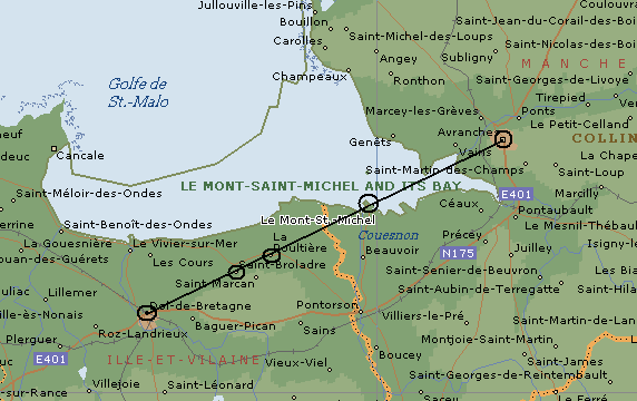
On the 8th of May (the
spring festival of St. Michael), the sun rises over d'Avranches towards
Mont St. Michel, then over Mont Dol and the huge
Dol-de-Breton.
Mont St. Michel is
also associated with a larger St. Michael's line, proposed to run
from Ireland to Jerusalem as the following map demonstrates.
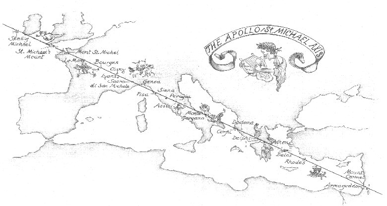
The alignment is said
to extend (on a Mercatorial map), from Mount Carmel in Israel through
Delos
(dedicated to Apollo),
Delphi,
Corfu (Island of Artemis, sister of Apollo), Le Monte Gargano in Italy
(primary European sanctuary of the Archangel, and place of several
apparitions), La Sacra di San Michele in Piemont (Benedictine monastery
at 1000m), Le
Mont St. Michel of Normandie, Saint
Mickael's mount, (a peaked island surmounted by a church off the coast
of Cornwall), and Skellig Michael, an island to the south-east of
Ireland. The angle of axis is orientated SE-NW corresponding to the
zodiacal axis of virgo-pisces (7).
(More about St. Michael)
Portuguese Ley-lines:

Three of the most
significant sites in Portugal are aligned in the direction of the spring
full-moon, along an azimuth of 110�. The alignment starts near
Evora, at the
Cromeleque dos Almendres, one
of Europe's oldest stone circles, which was constructed directly under
the moons maximum southerly latitude (Stonehenge was built under the
maximum northerly setting). Approximately 3 miles further along is the
Anta Grande do Zambujeiro passage mound,
the largest of its kind in all Iberia, and orientated along the same
azimuth of 110�. This beautiful example of an astronomical (lunar)
alignment terminates significantly at the original location of the
Cromeleque da Xarez, a stone quadrangle.
(More
about the Evora alignment)
Maltese Ley-lines:
The Island of Gozo is home
to the third-largest dome in the Christian world. (Which was built over a
huge dolmen) Also on Gozo, and apparently the only large megalithic
construction on the island, is the Ggantija temple complex, from which it is
just possible to see Malta through a notch in the hills. The sanctity of
this particular location is further emphasised by the presence of the Xagra
stone circle which was constructed over a 'Hypogeum' containing the remains
of several hundred bodies.
The 'Ta Cenc' Dolmen, the
Xewxra cathedral and the Ggantija/Xagra complex were all built in alignment
across the island. The Island has an interesting geomorphic quality about
it.
(More
about the Gozo alignment)
English Ley-lines: (Map
Ref: No's) below, refer to lines on the:
English Ley-line Map.
There
are too many proposed ley-lines in Britain to show them
all. The following few are some of the better known.
St. Michael's Ley
(Map Ref: 1) -
(Astronomical).
Runs across southern England from 'Land's End' to at least Bury St.
Edmonds'. Includes Glastonbury, Avebury, Walaud's Bank and The Hurlers.
(More
about St. Michael)
Stonehenge Ley (Map
Ref: 2)
- (Astronomical).
A 22 mile ley running from
'Castle Ditches' to a series of tumuli on 'Cow Down'. (Bearing 49� 15')
(2)
(More
about Stonehenge)
Old Sarum Ley
(Map Ref: 3) - 18� mile
alignment from just north of Stonehenge to the 'Frankenbury Camp'.
(Bearing 170� 45' - the same azimuth as the Glastonbury leyline.
(2)
(More
about Old Sarum)
Glastonbury Ley (Map
Ref: 4) -
21 mile alignment running from
Brockley to Butleigh. (Bearing 170� 40')
(2)
(More
about Glastonbury)
Rudstone Ley
(Map Ref: 5)
- 10 mile alignment from Willerby
to 'South side mount'. (Bearing 142�)
(2)
(More about Rudstone)
Uffington Ley (Map Ref:
6) -
9� mile alignment running from
Uffington past Dragon Hill to a round-barrow south of the M4. Crosses
the Ridgeway and the St. Michael's ley. (Bearing 4� 20')
(2)
(More
about Dragon Hill)
Devil's Arrows -
Thornborough Leys (Map Ref: 7, 8)
- Two alignments with a 'knee-bend'
at the Devil's arrows in Yorkshire.
The first ley (Map Ref: 7), starts
North at the Thornborough henges and ends at the Devil's arrows. The
three Thornborough henges are believed to have been erected around
1700-1400 BC (2), over the
pre-existing Thornborough Cursus. While the cursus (NE-SW), indicates a
Neolithic 'linear mentality', the ley alignment follows a different
azimuth, heading approximately NW-SE past the Nunwick henge towards the
Devil's arrows 11 miles away.
The second ley (Map Ref: 8) can be said to start
with two of the Devil's arrows, and continues another 5 miles SSE (150�
35'), past the Cana henge, on towards the Hutton moor henge. The Devil's
arrows (with at least one missing today) are known to have been
transported around 7 miles to their present location
(2).
(More
about the Devil's Arrows)
(Map
of English Ley-lines)
(Please
Contact-Us
if you know of any important leylines that
should be on this page)
(Geometric
Alignments) (British
Geodesy) (Geodesy
Homepage) (Egyptian
Geodesy)
(The
Nazca Lines, Peru)
(The
World Grid) |