|
Location:
Wiltshire, England.
(O/S - SU 100 685). |
Grid Reference: 51� 24� 50�� N,
1� 51' 24" W. |
 Silbury Hill:
(Conical Pyramid)
Silbury Hill:
(Conical Pyramid)
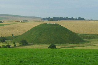 The largest artificial earth mound (pyramid)
in Europe. The largest artificial earth mound (pyramid)
in Europe.
Conical in shape, and rising to a height of 130 ft, with a
circular base more than 200 yards in diameter and a flattened top. Its total volume has been
estimated at 400,000 cubic feet. Excavations at the top and sides have
revealed no skeletal or funerary remains. There are indications that a large
pole may have once topped the hill.
(1)
The flattened top is 100ft in diameter, the same as the
exterior diameter of the Stonehenge
sarsen stones.
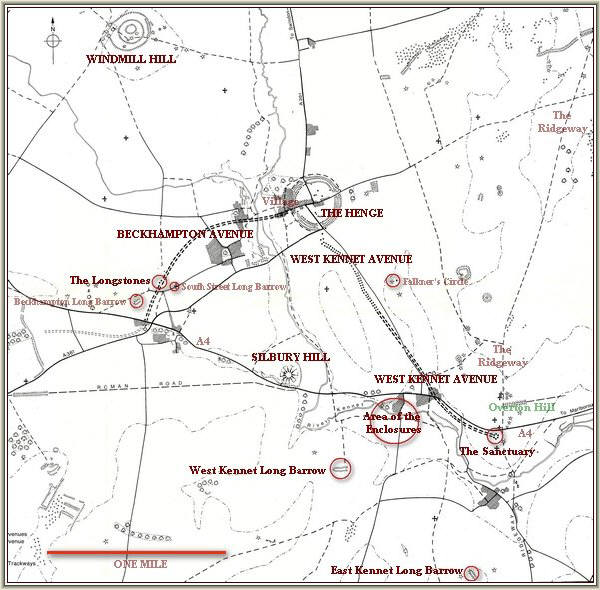
(Click here for Map of
site)
|
Physical Description of Silbury: |
Silbury Hill is a part of the complex
of Neolithic monuments around
Avebury in Wiltshire (which
also includes
the
West Kennet
long barrow and the
Sanctuary). It reveals an immense technical skill and
a prolonged control over labour and resources. Archaeologists calculate that
Silbury Hill took 18 million
man-hours to dump and shape 248,000 cubic metres (8.75 million cubic ft) of
earth on top of a natural hill.
The
base of the monument is 167m (550ft) in diameter and it is perfectly
round. Its summit is flat-topped and 30m (100ft) wide (The same as the
Sarsen circle at Stonehenge).
(More
about the Salisbury Complex)
The Silbury
'Moat':
The area
immediately surrounding the monument is lower than the level of the land
around it. The presence of natural springs offers the suggestion that in
the past the lowered area may have been filled in with water on occasion
creating a 'moat' effect similar to that
once surrounding Glastonbury Tor.
Extract From British Archaeology, Issue 70, 2003 -
'Archaeologists have come to see that ditches, even massive
ditches around henges or hillforts, need not always be just utilitarian
structures but may have had a metaphysical function too - for example, to
keep evil spirits at bay. The rectangular extension at Silbury, if
water-filled, would have served as a cistern or reservoir. Elsewhere in
the world, cisterns have often been the focus of ritual and ceremony. The
mirror-like quality of standing water may have had symbolic implications
too.
For just three days in early summer
2001, as the water-filled ditch dried out, a huge vegetation mark,
straight-edged and some 10m wide, appeared to extend across the ditch
floor for some 50m towards the mound. Its orientation, however, was
curious, running diagonally across the ditch extension towards a
position off-centre of the mound. The feature definitely seems
man-made. It may be that the hill's Neolithic builders dug a deeper
channel here to collect water from local springs and bring it to the
deep ditch encircling the mound.
It seems likely, then, that Silbury
Hill's ditches were intentionally filled with water. Furthermore, the
hill itself was built next to water, close to the River Kennet. The
siting of this monumental mound in a valley - so that its summit
barely attains the level of the surrounding hilltops - has often
raised comment. Why not build higher up? The answer must be that the
place itself was as important as the mound.' (4)
Being the largest
prehistoric mound of its kind in Europe, we can assume that the
construction of this hill was one of the most important
undertakings of its time but we are often reminded that there have
been no discoveries of funerary remains, chambers or any other
evidence that might explain its construction so how are we to
explain the presence of this monumental structure?
Geographically,
the mound sits in dip in the landscape, almost disguised by the
surrounding folds in the hills, yet its specific location must
have been an important consideration so it is likely for some
reason that this was a deliberate choice. At the same time, we are
reminded that the hill would have originally been white from the
chalk which would have made the hill shine like a beacon to those
who could see her. A White covering is also suspected on the three
henges at the Thornborough
Complex in Yorkshire suggestive of a ceremonial function.
Although there are several
other significant prehistoric structures in the area (including
the largest stone circle in the world at
Avebury), they sit in effective
isolation from each other. It is only from the top of the adjacent
Wodin hill that they can be viewed together, and a glimpse of the
larger ceremonial landscape can be imagined.
Silbury as the 'Primal
Mound':
The large conical
mounds found across UK have been suggested as representing the
'Primal Mound'. The concept of the primal mound is related to
creation myths concerning the origin of mankind itself. Several
other cultures such as Egyptian, Indian and Sumerian have references
to 'Primal mounds' which were all said to have emerged from the
watery chaos of the 'First time'. In the Egyptian mythology, Atum
was considered both the creator and the destroyer and the primal
mound itself, represented by the 'Ben-ben' and later through
Obelisks and Pyramids.
The most
significant 'Primal' mounds in Uk - such as Silbury, Glastonbury and
Maes Howe all share an association with water. It is now a common
belief that Silbury Hill was built deliberately so as to be
permanently surrounded by water. Similarly, Glastonbury was
surrounded by water when it was first in use during the Neolithic.
The Passage mound
of Maes Hill offers another interesting aspect of these purported
mounds which is that they are commonly associated with one or two
prominent nearby stone circles. Examples of this include
Newgrange (surrounded by a stone
circle), Gavr'inis in France (With
the twin circles of Er-Lannic
directly in front), and Ggantija on
the island of Gozo (Malta). Silbury Hill lies directly south of
Avebury, and less than a kilometre
away.
(More
about Primal Mounds and Stone circles)
Silbury as the
Earth-Mother:
The main advocate
of this theory is Michael Dames, who wrote in the 70's of his theory
that Silbury hill was constructed to represent the pregnant figure of the
Earth-mother itself. Dames became aware that the outline formed by
the moat surrounding Silbury resembled other prehistoric images of
the Earth-mother.
In order to support
his claim, Dames presented evidence of other examples of
Earth-mother profiles in ancient construction. In particular he
mentions both the Maltese temples and the dwellings on the Orkneys,
which have been noted for their anthropomorphic outlines. Perhaps
even more significant is that recent discoveries have revealed that
dwellings near Silbury were shaped anthropomorphically too.
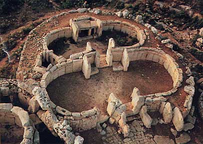
The Maltese Temples show a distinct similarity to
the outline of the Earth-Mother
(More
about the Earth-Mother-Earth)
Silbury as a Geodetic
Marker:
Silbury Hill was
built on a latitude with a geometric significance, as were
several other prominent prehistoric structures. In Egypt, it is
now realised that the temple complexes were located according to
'geodetic' principles, an it appears that the same can be said
of many of the European megalithic complexes. Both Karnak
(Thebes) and Giza/Heliopolis in Egypt were located on
latitudes which can be shown to have a geometric foundation. If
one divides the northern hemisphere into seven equal units (i.e.
90 �/7),
it can be seen that Karnak (Thebes), was placed on the second
division, Delphi on the third and Silbury Hill on the fourth.
In addition,
the same geometry can be seen in the exterior angles of the pyramids
of Giza. For example, the latitude of Silbury hill is mirrored in
the exterior angle of Menkaures pyramid, and it is perhaps no
coincidence that the exterior angle of Silbury hill is the same as
the latitude of Giza. At present, such information is brushed off by
most researchers as pure coincidence, but it is possible to see an
extension of this geometry in the other Giza pyramids, and at other
significant prehistoric locations.
(The
Salisbury Complex)
(More
about English Geodesy) (Geodesy
Homepage) (More
about Egyptian Geodesy)
Silbury as a Beacon Hill:
Silbury hill is
just one in a line of natural and artificial mounds along the St.
Michael's ley, which itself has a strong association with
astronomy.
Not only does the St. Michaels leyline pass both Glastonbury and
Silbury Hill, but it also passes other similar features along the
way such as the 'Barrow mump' and the 'Marlborough mound', both very
significant structures, and both suspected of having Neolithic
provenance.
The tradition of
burning beacons on hill tops to mark particular days is well
understood in England and there are numerous examples of 'Beacon
hills' and artificially flatten hill-tops reminding us that the
practice was important in connecting both the landscape and the
people together with solar and lunar cycles.
(More
about the St. Michael's Ley-line)
Although we are
left with no clear idea as to the original purpose of Silbury, we
do know that
it was built after other sites in the area such as Avebury
and West-Kennet which could mean that it was built simply to reinforce
the sanctity of the area so that while there is no questioning its
importance in the prehistoric landscape, the debate over its
actual function will have to remain academic until our
understanding of the Neolithic mind improves.
|
Chronology:
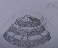
Silbury hill is estimated to have been constructed around 2,600 - 2,400
BC. It is now suggested
that the construction took two phases: soon after work was started, a
re-design was ordered, and the mound enlarged. It is constructed in steps,
each step being filled in with packed chalk, and then smoothed off.
Two small trenches cut
on the summit revealed a fragment of antler from a secure context, lying
against a chalk wall in a deposit of chalk rubble. This produced a
secure radiocarbon date of between 2490-2340 BC, placing the mound
firmly in the Late Neolithic (4).
|
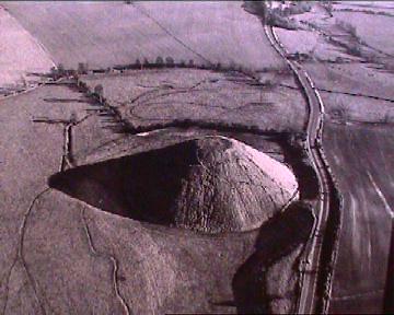
There have been three major excavations of the mound: the first when a team of
Cornish miners led by the Duke of Northumberland sunk a shaft from top to
bottom in 1776, another in 1849 when a tunnel was dug from the edge into the
centre, and a third in 1968-70 when professor Richard Atkinson had another
tunnel cut into the base. Nothing of any significance has ever been found on Silbury Hill: at
its core there is only clay, flints, turf, moss, topsoil, gravel, freshwater
shells, mistletoe, oak, hazel, sarsen stones, ox bones, and antler tines.
In 1969 Prof. Richard Atkinson attracted a great deal of interest as he
attempted to reveal the secrets of Silbury Hill near Marlborough. Such
was his enthusiasm, he even agreed to the BBC showing the dig on TV! The
BBC were present at Silbury for three seasons.
Atkinson and his team followed the line of an earlier
tunnel, dug in 1849 by Dean John Merewether but found nothing new about
the site.
|
Archaeological excavations (2007)...
Following the appearance of a hole in
the top in 2000, English Heritage began to organise an excavation to explore
and repair the Hill.
The cause of the hole
was determined to be a collapse from the unsatisfactory back-fill from
earlier excavations. It was decided to enter the tunnel dug by a team of
archaeologists in 1968 and back-fill it with chalk, also filling in the
voids created during the various excavations of the mound since the 1776
tomb-raiding exploits of the Duke of Northumberland.
A seismic survey was commissioned by National Heritage in
February 2002. it showed that the hill was stable, and unlikely to suffer
any further serious collapse. It also showed that before it was covered over
and smoothed, it had been built in the shape of a spiral, probably to assist
in the construction process. This same design has recently been determined
to have been used to construct the Great pyramid of Giza. (Ref: English
Heritage)
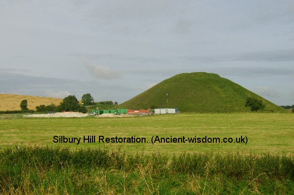
Porta-cabin compound at base of
Silbury hill (2007).
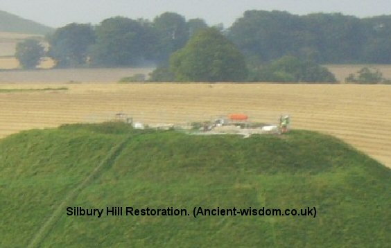
Work compound and light machinery on top of Silbury-Hill (2007).
'The most enigmatic find is sarsen stones, the same stone
as in nearby Avebury and Stonehenge, carefully incorporated in every stage,
some which would have taken two men to drag up to the very top of the mound'.
(3)
Atkinson's original research papers were investigated for
clues but it was found that the detailed plans of what Atkinson and Taylor
found when they reached the centre of the mound were missing from the
archive. (5)
|
|
Other Aspects of Silbury: |
Tradition and Myth:
According to legend, this is the last resting place of King Sil. Another legend states that the mound
holds a life-size solid gold statue of King Sil and yet a third, that the
Devil was carrying an apron of soil to drop on the citizens of
Marlborough, but he was stopped by the priests of nearby Avebury.
Astronomy:
Silbury hill sits on the St. Michaels ley-line which crosses
the longest stretch of England on the azimuth of the may-day sunrise or
'Beltane', a quarter-cross day marking the first day of summer and
the midway point between the spring equinox and the summer solstice.
The suggestion that a pole may have once topped the hill, is an
indication that the site could have served as a means of determining the
time of year (i.e. by the shadow cast), a similar theory to that proposed
for the
pyramids of Egypt by
Davidson (2).
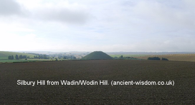
From the top of nearby Waden/Wodin hill, it is possible to
see how the setting may-day sun would have been viewed as it set below both
the horizon line and apparently into Silbury simultaneously.
Geometric Alignments:
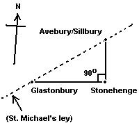
The Silbury/Avebury
complex together with
Stonehenge
and
Glastonbury,
combine to form a right angled triangle across the English landscape.
The Hypotenuse is formed by the St. Michael's ley-line, which crosses
England along the zenith of the May-day sun.
Avebury sits exactly 1/4 of a degree north of Stonehenge.
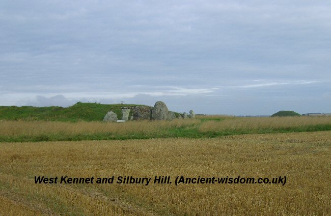
In this photo it is possible to see how the eastward
facing West Kennet long-barrow and the
top of Silbury Hill are on the same elevation (along with Wodin hill).
(Avebury) (West
Kennet Long Barrow) (The
Sanctuary)
(The Salisbury Complex)
(British Geodesy)
( Other Prehistoric English sites)
|